JACKSONVILLE, Fla. — The First Alert Weather Team said a First Alert Weather Day is in effect now through Sunday as Northeast Florida and Southeast Georgia will see strong storms throughout the weekend.
Watch CBS47 & FOX30 throughout the weekend for updates.

Here is the hour by hour forecast for Jacksonville. #FirstAlertWX https://t.co/ZDQFQdVHzv pic.twitter.com/25m0WRSQjS
— Garrett Bedenbaugh (@wxgarrett) February 14, 2021
UPDATE 5:15 p.m.
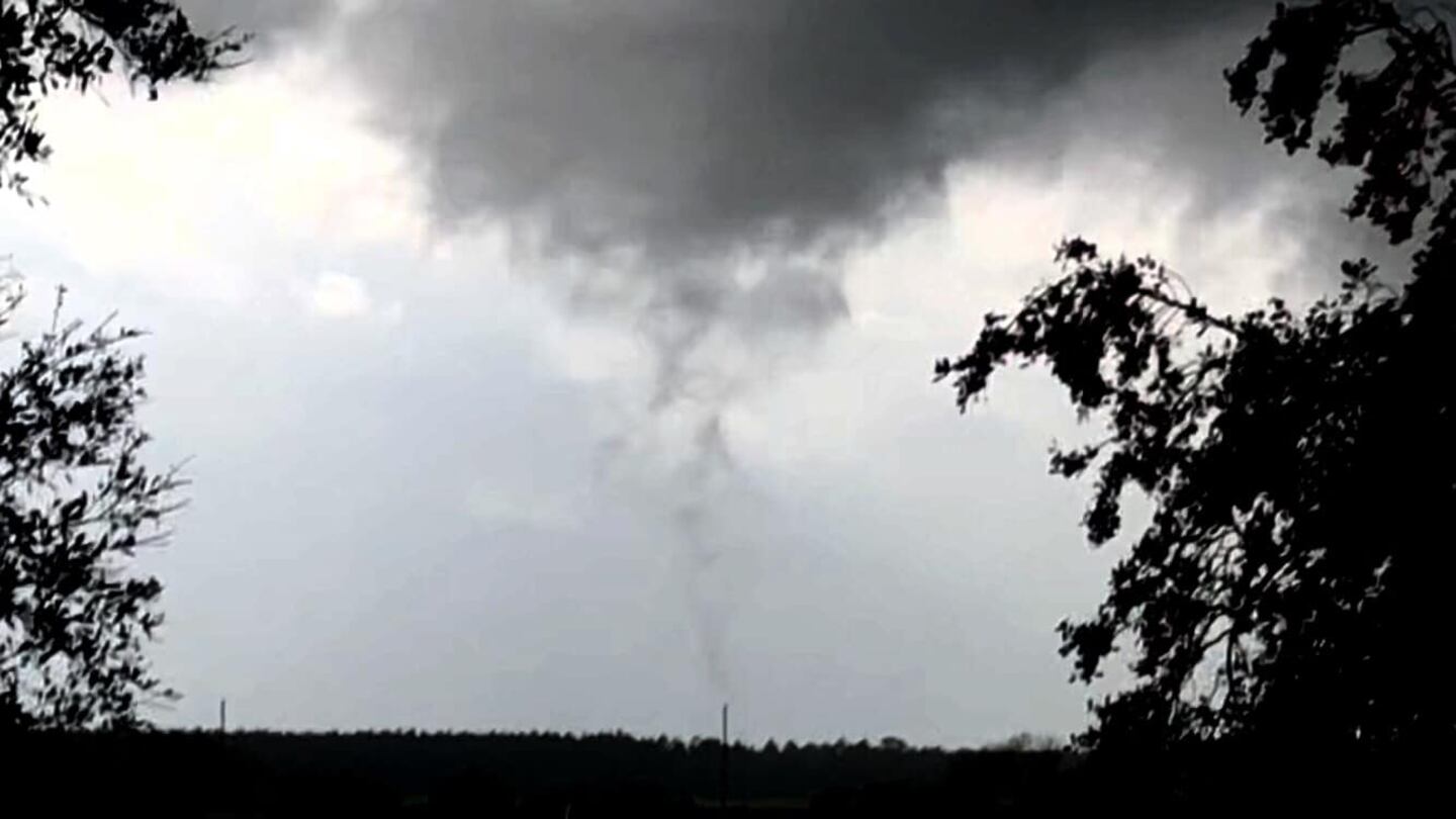
A brief tornado touched down in Baskerville near County Road 13A. It has been reported that tree limbs are scattered across the road near Molasses Junction.
Water pooling can also be seen near State Road 208.
Tracking the storms for ya in St. Johns County: Water pooling on CH Arnold off SR 208 here in Bakersville. pic.twitter.com/Hi4tikoIFd
— Stephanie Bennett (@StephanieANJax) February 14, 2021
UPDATE 2/14/2021 4:35 p.m.
Rain Reports: Heavy rain in the storms today is leading to higher rain reports today! 1+" already reported with another 3-4 hours left of rainfall.#FirstAlertWx pic.twitter.com/MFu5mnZPCY
— Alyssa Pejic (@AlyssaPejicWx) February 14, 2021
First Alert Weather Day continues through Monday.
The last line of “strong cells” are now offshore. The severe threat will continue to drop after sunset with cloudy skies and occasional showers.
Monday will be a cloudy, foggy and humid start with a few showers. Activity picks up from 6-11 p.m. as a squall line barrels through our area.
TONIGHT: Isolated shower, patchy fog. Low: 50
MON: Showers and storms. 77
- Main line of strong storms now offshore
- Severe weather threat will continue to diminish after sunset
- Lull in the action tonight with a few showers, cloudy skies and fog
- Monday also a First Alert Weather Day– area is under a slight risk
- Threats: damaging winds 40-60 mph, small hail, isolated tornadoes from 6-11 p.m.
Flood Warning until 5:15 pm for Clay, Putnam, & St. Johns Counties. Heavy rain from storms plus the 1-3" that have already fallen is causing flooding.#FirstAlertWx pic.twitter.com/NoU4urf75O
— Alyssa Pejic (@AlyssaPejicWx) February 14, 2021
Almost immediately upgraded to a TORNADO WARNING near Hollister west of Palatka #FirstAlertWX pic.twitter.com/cKuibgs3yL
— Corey Simma (@CSimmaWX) February 14, 2021
DOWNLOAD the First Alert Weather app to be notified of severe weather in your neighborhood
Sunday forecast:
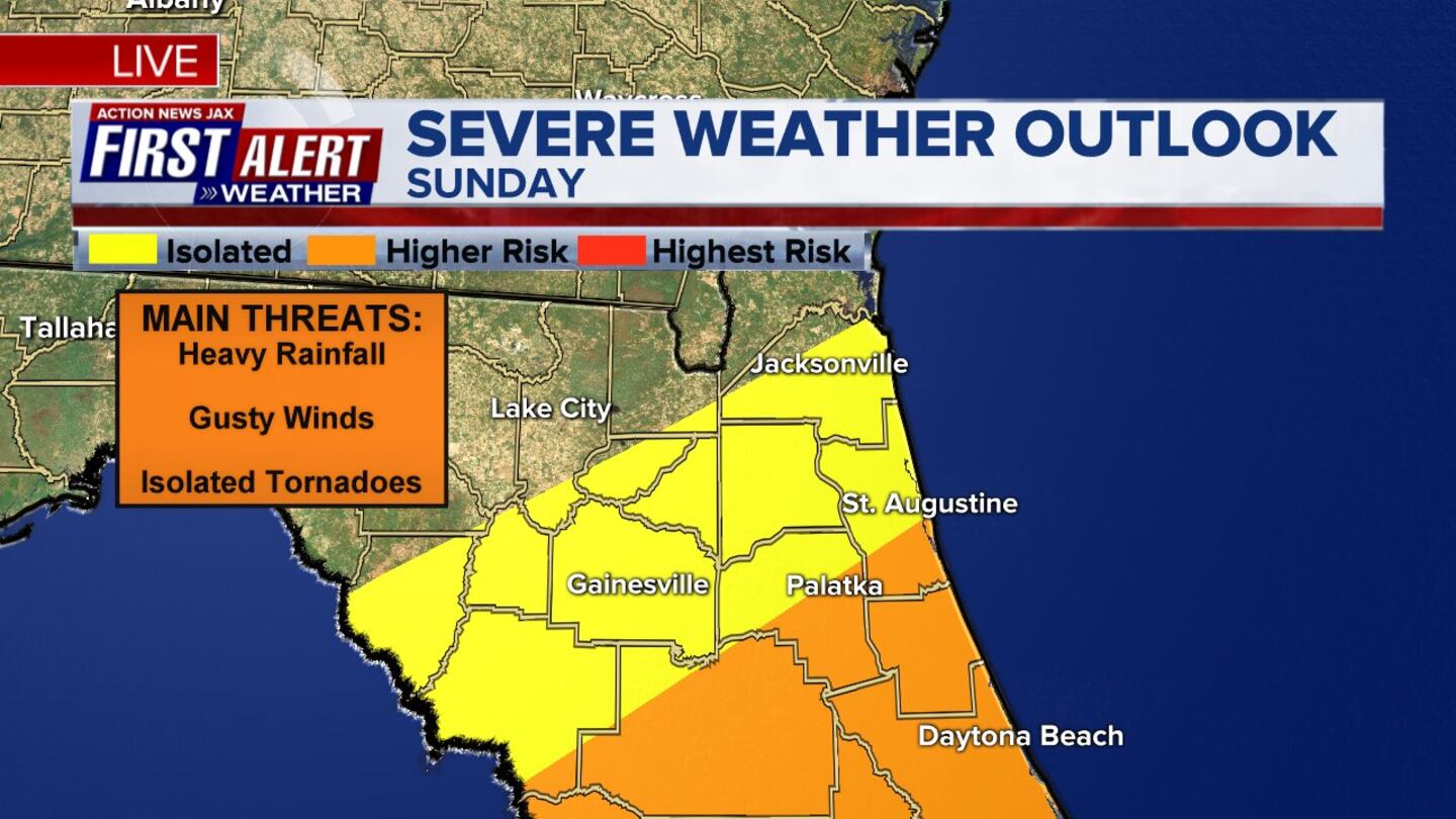
- Sunday there will be on and off rounds of showers with embedded storms producing heavy rain and damaging wind gusts
- There is an isolated tornado threat south of I-10 (under a marginal to slight risk)
- Localized flooding possible
Saturday evening forecast:
On Saturday evening activity will pick up as waves of heavy rain and isolated storms roll in off the Gulf. There is potential for a strong storm south of I-10 Saturday evening.
Overnight activity will be less but there will still be a few rounds of showers with fog. Main flooding threat shifts from the Florida panhandle and South Georgia Saturday to Northeast Florida and Southeast Georgia Sunday.
There is a threat for heavy rain and severe storms and an isolated tornado Sunday south of I-10.
SATURDAY NIGHT: Cloudy with a few showers, Fog. Low: 55
Saturday morning forecast:
Expect a few showers lifting up into Georgia Saturday morning while Northeast Florida is a touch cool and foggy. Some dry hours Saturday morning before the next big wave of rain tracks across the area early this afternoon.
There will be some lightning and thunder with Saturday’s afternoon activity. Rain extends into the evening and tonight as the next heavy bands of rain move in on Sunday.
Main flooding threat shifts from the Florida panhandle and South Georgia on Saturday to Northeast Florida and Southeast Georgia on Sunday.
SATURDAY MORNING: Scattered Showers and Thunderstorms. High: 70
Here’s what you can expect throughout the weekend:
- Scattered heavy showers and a few storms over the next few hours Friday afternoon/evening. Some neighborhoods will see a quick 1″ to 1.5″ of rain. An isolated strong/severe storm is possible.
- There will be a break from the heavier middle of the night before more showers, a thunderstorm develops late Friday night.
- Some areas will see dense fog Friday night.
- Expect showers and drizzle much of the day Saturday north of Interstate 10 into Southeast Georgia.
- Scattered showers and a few storms can be expected near/south of I-10; heavy rain at times – especially in the afternoon/evening & especially southern/western parts of the viewing area.
- Some risk for a strong storm for the southern parts of our viewing area Saturday.
- On and off waves/bands of heavy rain and storms Saturday night through Sunday. A strong/severe storm possible, but greatest concern looks to be heavy rain & possible flooding.
- Rainfall today through Sunday night will average 2″ to 4″ but more in some areas. This is on top of the heavy rain that’s saturated soils from last Saturday and Tuesday.
- Small stream/urban flooding possible at anytime but river flooding possible along the St. Johns, St. Marys, Black Creek, Santa Fe River & any tributaries connected to these river/streams/creeks.
INTERACTIVE RADAR: Keep track of the rain as it moves through your neighborhood
Cox Media Group


