:quality(70)/cloudfront-us-east-1.images.arcpublishing.com/cmg/WW5AJL3ARQUGDQMAQUNSFX4CLE.jpg)
Jacksonville, Fl. — The “Buresh Bottom Line”: Always be prepared!.....First Alert Hurricane Survival Guide... City of Jacksonville Preparedness Guide... Georgia Hurricane Guide.
STAY INFORMED: Get the * FREE * First Alert Weather app
FREE NEWS UPDATES, ALERTS: Action News Jax app for Apple | For Android
WATCH “Preparing for the Storm”
WATCH “The Ins & Outs of Hurricane Season”
READ the First Alert Hurricane Center “Survival Guide”
LISTEN & WATCH “Surviving the Storm” - WOKV Radio & Action News Jax
***** ALWAYS CHECK & RE-CHECK THE LATEST FORECAST & UPDATES! *****
REMEMBER WHEN A TROPICAL STORM OR HURRICANE IS APPROACHING: Taping windows is *NOT* helpful & will not keep glass from breaking.
Realize the forecast cone (”cone of uncertainty”) is the average forecast error over a given time - out to 5 days - & *does not* indicate the width of the storm &/or damage that might occur.

** No tropical systems will directly impact Jacksonville/NE Fl./SE Ga. through the weekend.... **
Atlantic Basin:
A lead tropical wave - ‘96-L’ was upgraded to tropical depression #7 Wed. morning then to tropical storm “Fiona” Wed. evening. Fiona has been battling a narrow but significant - 30-40 mph - band of westerly shear to its immediate west & northwest which is causing much/almost all of the shower & t’storm activity to stay over the eastern portions of the circulation but intense bursts of thunderstorms have been persistent allowing for intensification Wed. which has become mostly steady state. Forecast models generally show some development but maintain a *relatively* weak system (tropical storm) upon approach to the Northeast Caribbean by late Fri. into Saturday. The westerly shear + somewhat dry air nearby is most likely why models show only modest development. But it’s worth noting Fiona has so far managed to organize & strengthen despite less than ideal conditions. Heavy rain & gusty winds can be expected for Puerto Rico, the Virgin Islands, Hispaniola & nearby islands by Fri. into the weekend. Of concern, is the GFS forecast for Fiona to become a hurricane before reaching Puerto Rico. The model is an outlier for right now + the GFS has had a tendency to be too aggressive so far this hurricane season, but it’s something to watch carefully.
From the Greater Antille Islands, forecast models are trending northward next week with Fiona which seems reasonable though how sharply to the north is up for great debate. As for how fast Fiona moves, most of the models are now in decent agreement with a hurricane at Jacksonville’s latitude but far to the east (between 500 & 1,000 miles) by Thu./Fri. next week. So the European model is not as fast as past days while the GFS has maintained its slow movement. The European model continues to take a relatively weak Fiona just about due west over/near Puerto Rico then over Hispaniola before turning more north while intensifying once east of the Bahamas. The GFS model, on the other hand, takes a strengthening Fiona a little north of Puerto Rico then northward while intensifying quickly. Obviously - this is a major difference, especially for the Leeward Islands & possible impacts. Any interaction with the land masses of Puerto Rico & Hispaniola will have impact on the strength & structure of Fiona. On the current official forecast track, Fiona would stay just a little east of the highest mountain ranges of Haiti & the Dominican Republic. It’s this part of the forecast - Puerto Rico & Hispaniola - that right now is the most critical & is as well the biggest question mark. The two most major steering influences will be: (1) the Bermuda high (clockwise circulation) which remains well to the northeast over the Atlantic... & (2) the strength of Fiona - weaker is longer to the west, stronger is faster to make the turn more northwest then north.
Overall - once away from the Greater Antilles/Leeward Islands - it would appear overall conditions (water temps., shear & moisture) will favor strengthening next week. It *appears* Fiona will stay east of Florida & the U.S. east coast, but it’s still early on this part of the forecast, & we shouldn’t let our guard down on a track more west. In fact, a typhoon has moved inland on the coast of China while another typhoon over the W. Pacific will turn sharply to the north then northeast impacting Japan over the weekend. This typhoon teleconnection might correlate rather well with Fiona over the W. Atlantic next week & the rather sharp turn north & northeast. This correlation is possible because of the upper level pattern - troughs (dips) & ridges (upside down U’s) in the jet stream - that often (not always) mimics each basin (Pacific & Atlantic).
So to recap: Fiona is a storm that will have at least some impact on the Northern Leeward & Windward Islands of the Caribbean through the weekend... then eventually *perhaps* an impact to some of the Bahamas next week followed by a move north then northeast. It’s still early on a system that is not real well developed & that has plenty of question marks ahead.
Elsewhere... a pretty vigorous tropical wave has come off the coast of Africa & is moving westward with some potential for slow development.
Some weak low pressure may also develop this weekend/early next week over the Western Atlantic to the east of the Carolina’s in response to an upper level trough. Initially the low may not move much, & it’s an area to monitor.


Mountainous terrain over especially the Central & Western portions of Hispaniola:
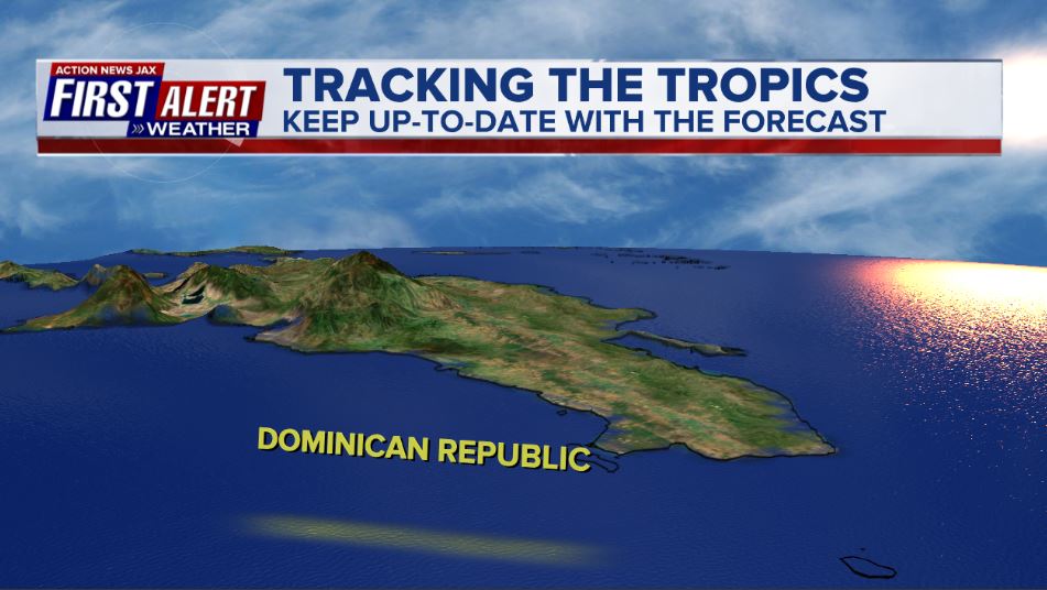
Image Courtesy: NASA/JPL/SRTMImage

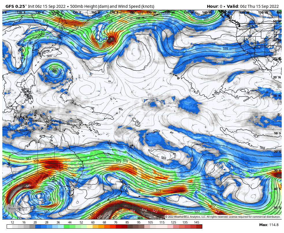
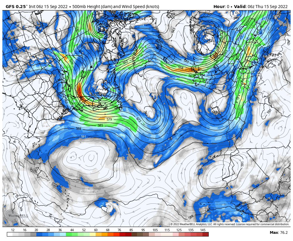
Possible upper level (about 30,000 feet) teleconnection with troughs & ridges between the Atlantic (steering Fiona) & the Pacific (steering W. Pacific typhoons):


Water vapor loop shows some dry air near wave ‘96-L’, but it’s more moist than past days:


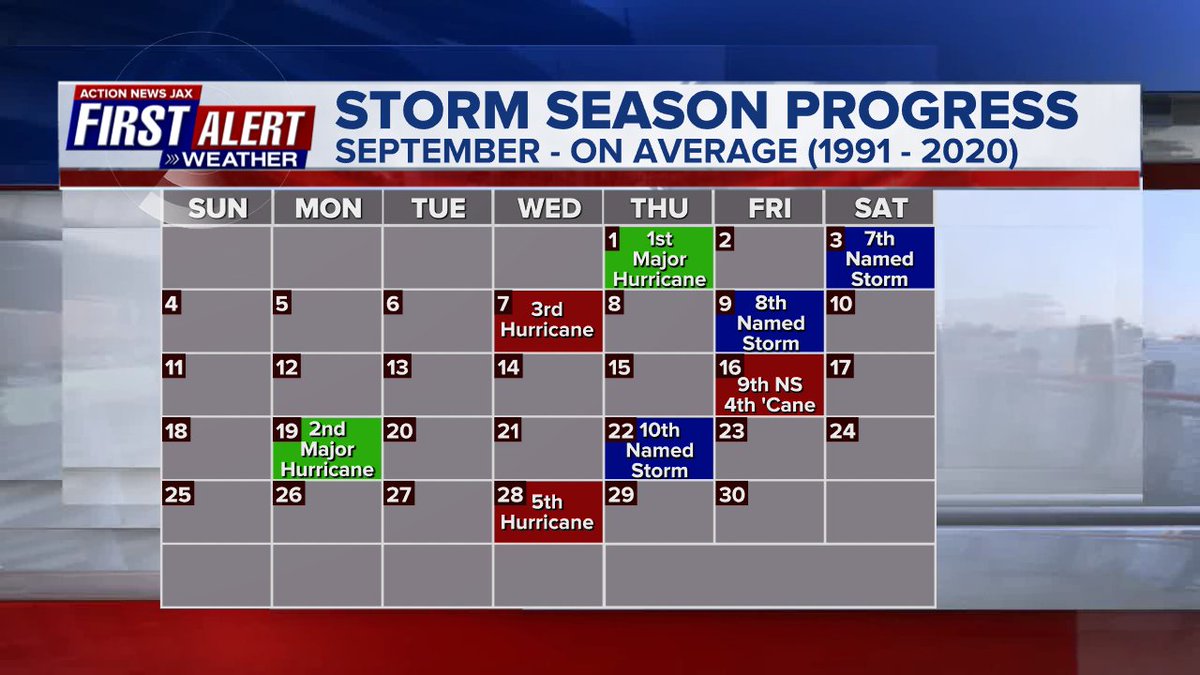
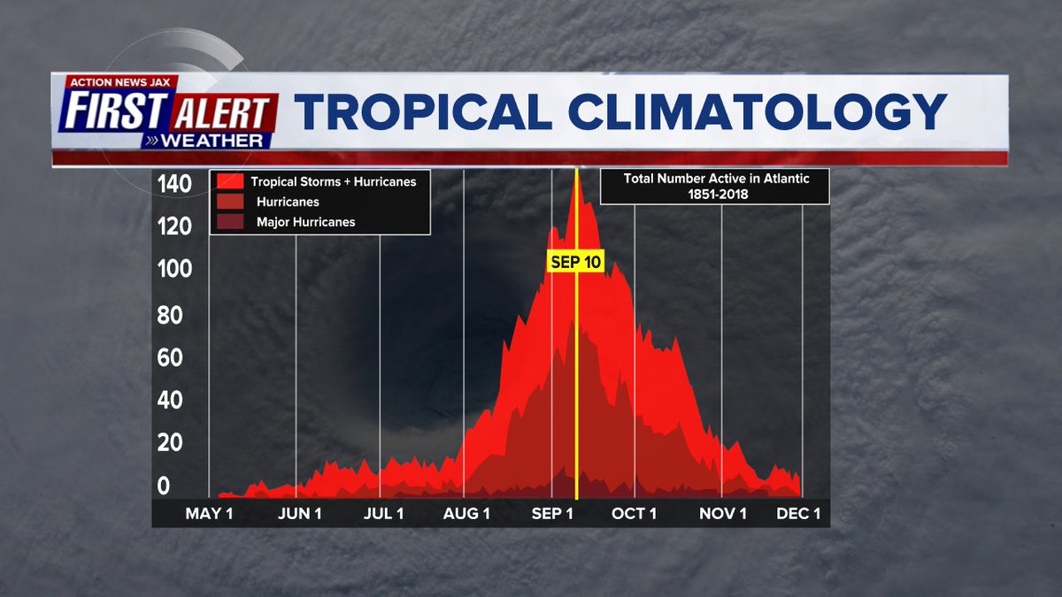
September origins:
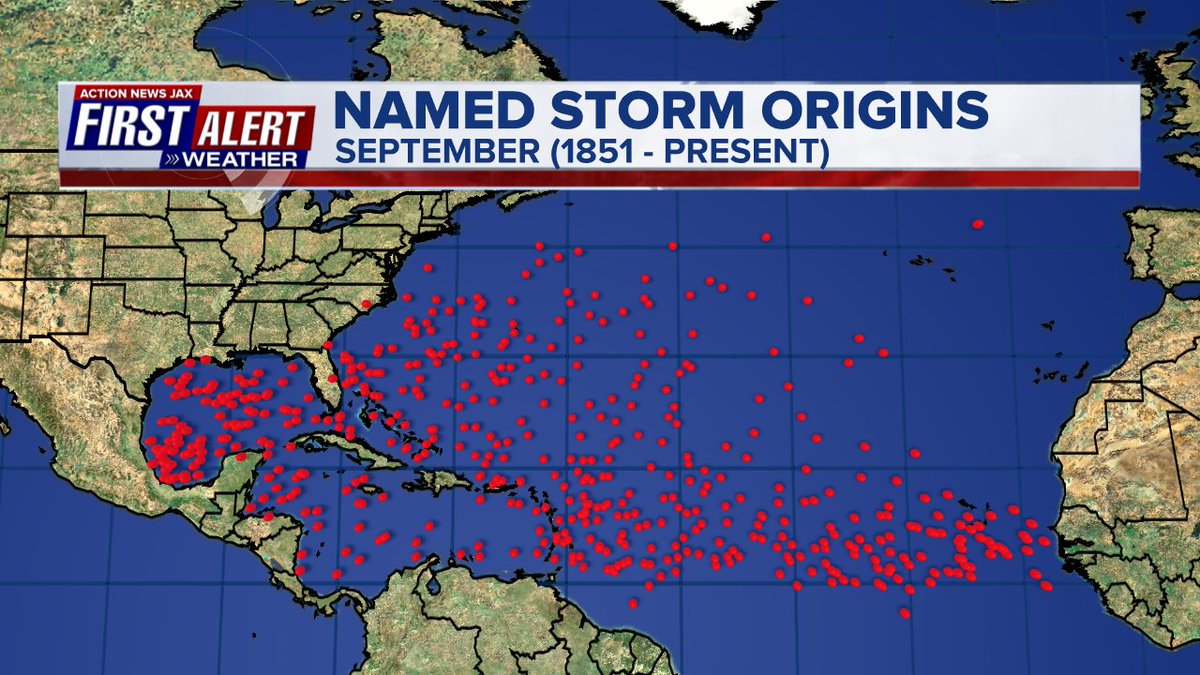
Averages below based on climatology for the Atlantic Basin through September. This season so far is well below avg.:
Wind shear:


Saharan dust spreads west each year from Africa by the prevailing winds (from east to west over the Atlantic). Dry air - yellow/orange/red/pink. Widespread dust is indicative of dry air that can impede the development of tropical cyclones. However, sometimes “wanna’ be” waves will just wait until they get to the other side of - or away from - the plume then try to develop if other conditions are favorable. In my personal opinion, way too much is made about the presence of Saharan dust & how it relates to tropical cyclones. In any case, we’ve had several large dust plumes spread west to the Caribbean & Gulf with the peak of Saharan dust typically in June & July.

2022 names..... “Gaston” is the next name on the Atlantic list (names are picked at random by the World Meteorological Organization... repeat every 6 years). Historic storms are retired [Florence & Michael in ’18... Dorian in ’19 & Laura, Eta & Iota in ‘20 & Ida in ‘21]). In fact, this year’s list of names is rather infamous with “Charley”, “Frances”, “Jeanne” & “Ivan” retired from the ‘04 list (all hit Fl.) & “Matthew” was retired in 2016. The WMO decided - beginning last year - that the Greek alphabet will be no longer used & instead there will be a supplemental list of names if the first list is exhausted (has only happened three times - 2005, 2020 & 2021). The naming of tropical cyclones began on a consistent basis in 1953. More on the history of naming tropical cyclones * here *.


East Atlantic:


Mid & upper level wind shear (enemy of tropical cyclones) analysis (CIMMS). The red lines indicate strong shear:

Water vapor imagery (dark blue indicates dry air):

Deep oceanic heat content over the Gulf, Caribbean & deep tropical Atlantic:

Sea surface temp. anomalies:


SE U.S. surface map:

Surface analysis centered on the tropical Atlantic:

Surface analysis of the Gulf:

Caribbean:

GFS wave forecast at 48 & 72 hours (2 & 3 days):


Atlantic Basin wave period forecast for 24, 48 & 72 hours respectively:


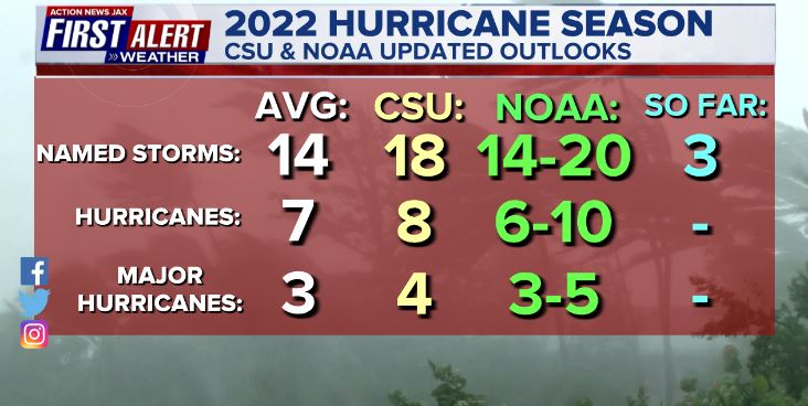
Updated Atlantic seasonal forecast from early Aug. - NOAA & CSU:
The East Pacific:


West Pacific:

Global tropical activity:


“Muifa” is inland over China & weakening:

“Merbok” is forecast to stay over the open water of the W. Pacific moving northeast well to the east of mainland Japan:

Strengthening typhoon “Nanmadol” is over the W. Pacific & is forecast to impact the Southern Japanese islands through Fri. & much of Japan (main island) late in the weekend into early next week:

Cox Media Group
:quality(70)/cloudfront-us-east-1.images.arcpublishing.com/cmg/LW2VP2Y6PJDZPLDJCDBZRFVCAI.png)
:quality(70)/d1hfln2sfez66z.cloudfront.net/04-19-2024/t_744a0fe392b04fa194c322a11f1cea0c_name_file_960x540_1200_v3_1_.jpg)
:quality(70)/cloudfront-us-east-1.images.arcpublishing.com/cmg/N7YMXJTJYJEFBCXSUI6KPLO7OM.png)

:quality(70)/cloudfront-us-east-1.images.arcpublishing.com/cmg/V5TWF6CJAZFXBLDTZXOE47OMN4.jpg)