
Jacksonville, Fl. — The “Buresh Bottom Line”: Always be prepared!.....First Alert Hurricane Survival Guide... City of Jacksonville Preparedness Guide... Georgia Hurricane Guide.
STAY INFORMED: Get the * FREE * First Alert Weather app
FREE NEWS UPDATES, ALERTS: Action News Jax app for Apple | For Android
WATCH “The Ins & Outs of Hurricane Season”
WATCH “Preparing for the Storm”
READ the First Alert Hurricane Center “Survival Guide”
***** ALWAYS CHECK & RE-CHECK THE LATEST FORECAST & UPDATES! *****
REMEMBER WHEN A TROPICAL STORM OR HURRICANE IS APPROACHING: Taping windows is *NOT* helpful & will not keep glass from breaking... & realize the cone is the average forecast error over a given time - out to 5 days - & *does not* indicate the width of the storm &/or damage therefore do not become fixated on the center of a tropical system.

Ida:
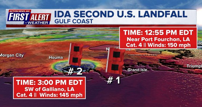
Landfall: NOAA Doppler radar imagery indicates that the eye of Ida made landfall along the southeastern coast of Louisiana near Port Fourchon - about 100 miles south of New Orleans - around 1155 AM CDT (1655 UTC)/12:55pm EDT. Data from an Air Force Reserve reconnaissance aircraft and Doppler radar data indicate that Ida’s maximum sustained winds at landfall were estimated to be 150 mph (240 km/h). The minimum central pressure estimated from reconnaissance aircraft data was 930 mb (27.46 in). A second landfall - with winds still near 145 mph/Cat. 4 - occurred near 3:00pm EDT just SW of Galliano, La.
Ida was slow to lose “steam” Sunday afternoon & night despite landfall. Known as the “brown ocean effect”, Ida’s proximity to the very warm Gulf with the eye still very near the ocean & over inlets, bogs & estuaries likely helped “feed” Ida for some time. Coupled with nearly ideal upper level conditions - venting [or diffluence] aloft - Ida was still a hurricane past midnight Sunday before finally being downgraded to a tropical storm Monday morning then a tropical depression late Mon. afternoon.
SUMMARY:
As feared since last Wed. (”TTTWM, Aug. 25 *here*), Ida will be a major/historical hurricane hit on the Central Gulf Coast with particular focus on Louisiana/Mississippi. The approach from the southeast nearly 100 miles south of New Orleans spared the Crescent City the highest winds but there were still major impacts on the city including A LOT of water - both fresh (rain) & salt (surge) & a 100% power outage.
Ida was a tropical wave that originated off of Africa & has been steadily marching west waiting for a more favorable environment (less dust, more moist atmosphere & less shear). The system found that more favorable area & was upgraded to t.d. #9 Thu. morning then t.s. “Ida” late Thu.... & a hurricane early Fri. afternoon followed by a landfall on the Island of Youth then Western Cuba Fri. evening becoming a “major” hurricane overnight Saturday with a third & fourth landfall - & the first U.S. landfall early Sun. afternoon. Moving inland with increased friction, drier mid & upper level air + increasing shear will result in pretty fast weakening Mon., but it was too little too late to spare Louisiana & New Orleans & Mississippi one of the most severe hurricane hits on record for the local area.
A warm “eddy” over the Gulf of Mexico - similar to 2005 [Katrina & Rita] - did indeed seem to help Ida intensify Sat. night/early Sunday during a classic rapid intensification cycle (RIC). Despite fairly rapid movement - by tropical standards - Ida deepened fast within a moist atmosphere, low shear, strong upper level ventilation & warm water to develop into a major hurricane appearing to fall just short of Cat. 5 intensity (to be truly determined in post storm surveys & research). Ida was reminiscent of some of the most infamous U.S. landfalling hurricanes on record strengthening over a short period of time while approaching land: Laura, Michael, Andrew, Camille & the 1935 Labor Day hurricane to name just a few.
Ida continues the string of “bad luck” for Louisiana after 3 hurricanes & 1 tropical storm landfall last year in addition to tropical storm Claudette this year.
Double digit storm surge occurred just to the east of the eye where waves were measured at more than 40 feet! Dangerous storm surge occurred all the way east to Mobile, Al. with notable storm surge as far east as Pensacola, Fl. Much of New Orleans is essentially a bowl, so water would have been very slow to recede *but* much of the levee system - rebuilt after Katrina - held up to its biggest test since the reconstruction since 2005.
Rainfall of 1-2 feet on top of saturated ground is adding to the water/flooding woes.
Once inland, very heavy rain, flooding & a few tornadoes will extend far to the north & northeast including parts of the Tennessee Valley, Lower Ohio Valley & Mid-Atlantic states through Thursday. Anyone near & along the future path of what’s left of Ida should not let their guard down as severe flooding may occur from the Tennessee & Kentucky & the Western Carolina’s north through Virginia, W. Virginia, Pennsylvania & parts of the Northeast.
Finally.... ‘I’ is rather notorious over the years & is the most retired letter of the Atlantic seasonal alphabet. Since 1955, there have been 11 ‘I’ names retired including Iris, Isidore, Isabel & Ivan in consecutive years from 2001-’04. Most recently Irma was retired in 2017 & Iota in 2020. Tied for second in retired letters is ‘C’ & ‘F’ with nine each.


South Florida Water Management District radar imagery as the tail end of tropical moisture form Ida moves north & east:

Meanwhile... Julian & tropical storm Kate: tropical depression #10 formed early Sat. becoming tropical storm “Kate” Mon. morning. Tropical depression #11 became tropical storm “Julian” Sunday morning but was already post-tropical Sun. night. Neither of these systems will make much progress west even staying well southeast & east of Bermuda so no threats to any land areas.

Yet another strong tropical wave has moved off the coast of Africa. While this one is likely to become a strong hurricane, it also appears that this one will turn northward relatively early which would keep the system well east of the U.S. & well northeast of the Caribbean. By the weekend into next week, there may be an easterly swell reaching U.S. east coast beaches.
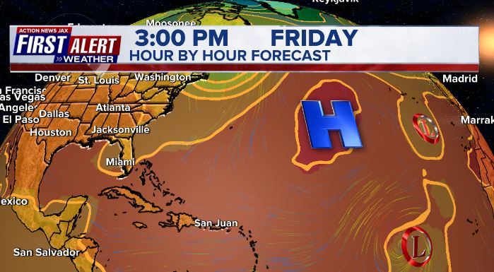
So some good news!: For right now, the Bermuda High across the Atlantic is displaced to the east & northeast (see the 500mb forecast for Fri. below) - & generally weaker - into at least early Sept. - important for any potential long track tropical systems coming out of the deep tropics. If the Bermuda High stays weaker, it will be difficult for a long track tropical cyclone to make it all the way across the Atlantic... at least over the next couple of weeks or so.

However..... there are some hints of possible gradual tropical development over the Western Caribbean &/or Western Gulf over the next week or so evolving from an area of disorganized storminess over the Southern Caribbean (IR sat image below). This will be something to keep a close eye on with potential impacts - it would appear - for Mexico or *possibly* South Texas.


We’re now less than 2 weeks from the peak of the hurricane season (Sept. 10), so just from a climatological point, we should see an uptick in Atlantic activity. But there are also other indications to track including the MJO, seasonally warm sea surface temps. & rather impressive deep oceanic heat content.
Sea surface temps. across the Atlantic are now near to above avg. across much of the basin (2nd image below) & - even more importantly - deep oceanic heat content (which helped “feed” Ida) is impressive & the “equivalent oceanic heat content” - namely depth averaged temperature in the upper 300 m (~984 feet) - is even more impressive all the way from Africa to the Gulf of Mexico. Such an ocean water temp. pattern is conducive to long track deep tropical Atlantic tropical cyclones & can lead to a more favored regime for rapid intensification cycles. From an AMS research paper in ‘08 Mainelli, DeMaria, Shay, Goni: “Results show that for a large sample of Atlantic storms, the OHC variations have a small but positive impact on the intensity forecasts. However, for intense storms, the effect of the OHC is much more significant, suggestive of its importance on rapid intensification. The OHC input improved the average intensity errors of the SHIPS forecasts by up to 5% for all cases from the category 5 storms, and up to 20% for individual storms, with the maximum improvement for the 72–96-h forecasts. The statistical results obtained indicate that the OHC only becomes important when it has values much larger than that required to support a tropical cyclone.” More recent research continues to indicate similar correlations.


Saharan dust. Dry air - yellow/orange/red/pink. Widespread dust is indicative of dry air that can impede the development of tropical cyclones. However, sometimes “wanna’ be” waves will just wait until they get to the other side of the plume then try to develop if everything else happens to be favorable. In my personal opinion, way too much is made about the presence of Saharan dust & how it relates to tropical cyclones.

2021 names..... “Larry” is the next name on the Atlantic list (names are picked at random by the World Meteorological Organization... repeat every 6 years... historic storms are retired (Florence & Michael in ’18... Dorian in ’19 & Laura, Eta & Iota in ‘20). Last year - 2020 - had a record 30 named storms. The WMO decided beginning in 2021 that the Greek alphabet will be no longer used & instead there will be a supplemental list of names if the first list is exhausted (has only happened twice - 2005 & 2020). More on the history of naming tropical cyclones * here *.


East Atlantic:


Mid & upper level wind shear (enemy of tropical cyclones) analysis (CIMMS). The red lines indicate strong shear:

Water vapor imagery (dark blue indicates dry air):

Deep oceanic heat content continues to increase across the Gulf, Caribbean & deep tropical Atlantic & has become pretty impressive from the Central/NW Caribbean into the Gulf of Mexico:

Sea surface temp. anomalies:

SE U.S. surface map:

Surface analysis centered on the tropical Atlantic:

Surface analysis of the Gulf:

Caribbean:

Atlantic Basin wave forecast for 24, 48 & 72 hours respectively:


The East Pacific:
Nora has dissipated while hugging the coast of Mexico & moving inland enough to rob the storm of the needed warm ocean “fuel”. This was an excellent forecast by the GFS model which has been a “stud” so far this season. But tropical moisture remains with the moisture streaming northward bringing possible flooding to Arizona & New Mexico perhaps as far north as parts of the Rocky Mountain states:


West Pacific IR satellite:

Global tropical activity:


Cox Media Group


