
4:34 PM: #Naples Municipal Airport recorded a wind gust of 142 mph (WeatherBug mesonet NPLMP). #Irma
— NWS Miami (@NWSMiami) September 10, 2017
Sept. 11, 2017 — WATCH LIVE 24/7: Hurricane Irma updates for Jacksonville and vicinity
HURRICANE IRMA: Latest updates, shelter info, evacuation info
STAY INFORMED: First Alert Weather app (latest track, radar, warnings)
Irma is moving away from Jacksonville & all of Florida.
Jacksonville N.W.S. Doppler radar:

Hurricane Irma made the turn to the northwest & now north after ravaging the Keys. Ft. Myers & much of Florida. this is the first "major" Fl. hurricane landfall since Cat. 3 "Wilma" in Oct., 2005 (Twitter did not yet exist!)...
The "Buresh Bottom Line" is: stay tuned!... Always be prepared!..... City of Jacksonville Preparedness Guide... Georgia Hurricane Guide.
Local Impacts:
- rough seas & surf will gradually subiside through Tue.
- While storm surge caused by hurricane Irma was - overall - less than with Matthew last year, there were exceptions. The surge height for downtown Jacksonville was a record & beat "Dora" from 1964. Peak wind gusts ranged from 70-85 mph at the beaches to 50-70 mph inland. Rainfall average 6-12" but when combined with rain leading up to Irma exceeded 15" in places. High tide departures will only slowly subside for the rest of the week.
"Irma" finally made the northwest then northward turn Sat. night pounding the Keys as a Cat. 4 hurricane with the eye moving just east of Key West.
The weak upper level trough/ "alleyway" in the upper levels of the atmosphere has finally pulled stubborn Irma north. A strong surface high will build into the Northeast U.S. which will block Irma from getting too far north while an upper level ridge builds underneath the departing trough. So Irma's remnants will get trapped over the Tennessee Valley before dissipating which will mean heavy rain for parts of N. Ga., N. Alabama & Tennessee.
SUNRISE: ~7:10 AM .... SUNSET: ~7:35 PM


"Irma" model plots:


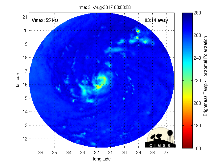
Fascinating imagery(!) from CIMMS, University of Wisconsin, Madison - Microwave radar-simulated imagery showing Irma wrapping up... click here for full definition.....

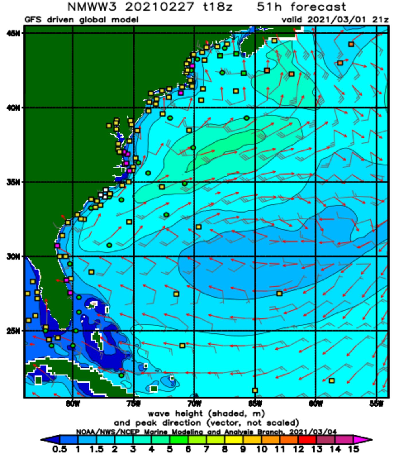
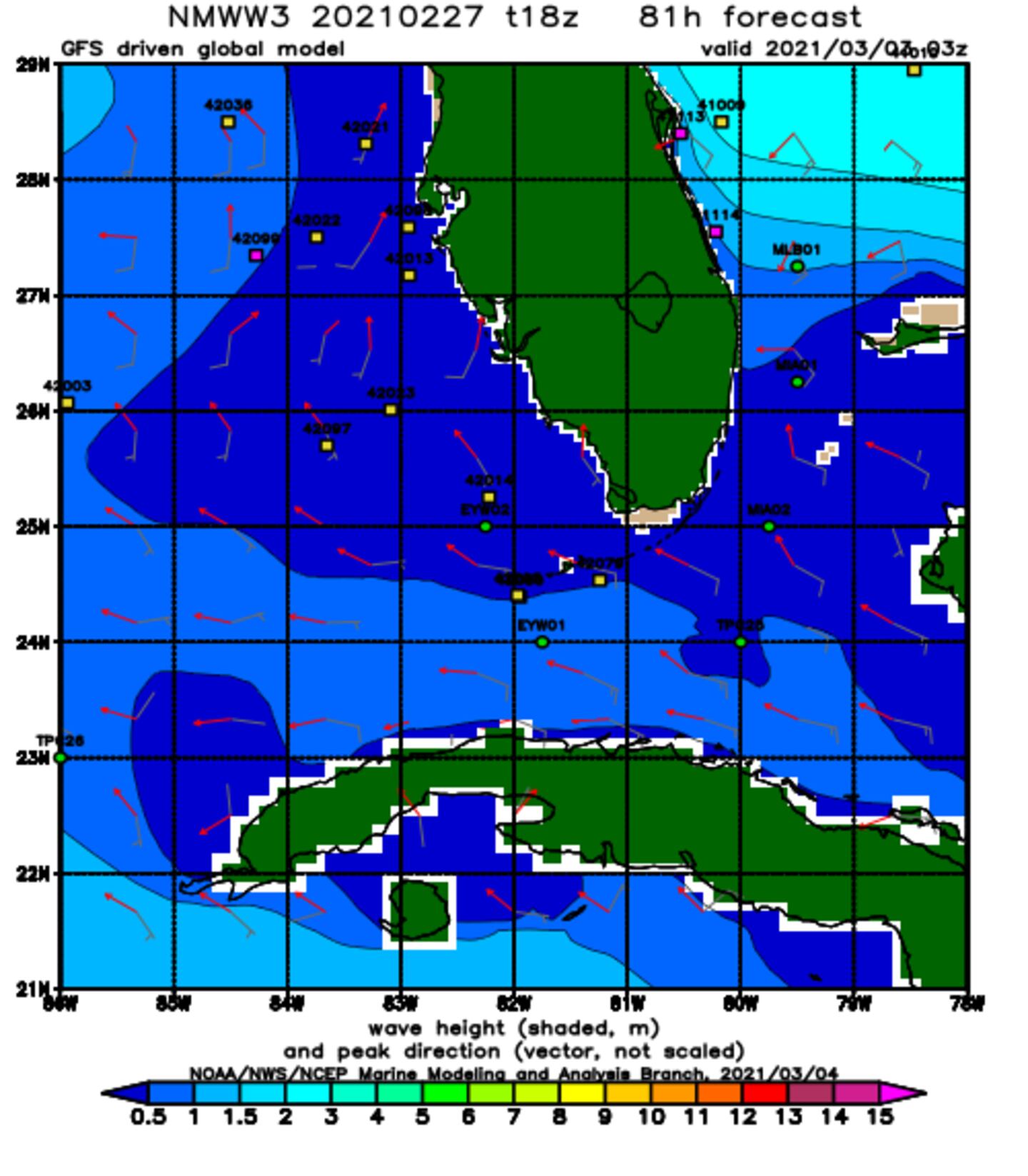
Wave forecast:.
NOAA WaveWatch III below predicated on GFS model - will change & update - hit refresh for latest + loop:
Hurricane "Jose" to the east/southeast of "Irma"....
0
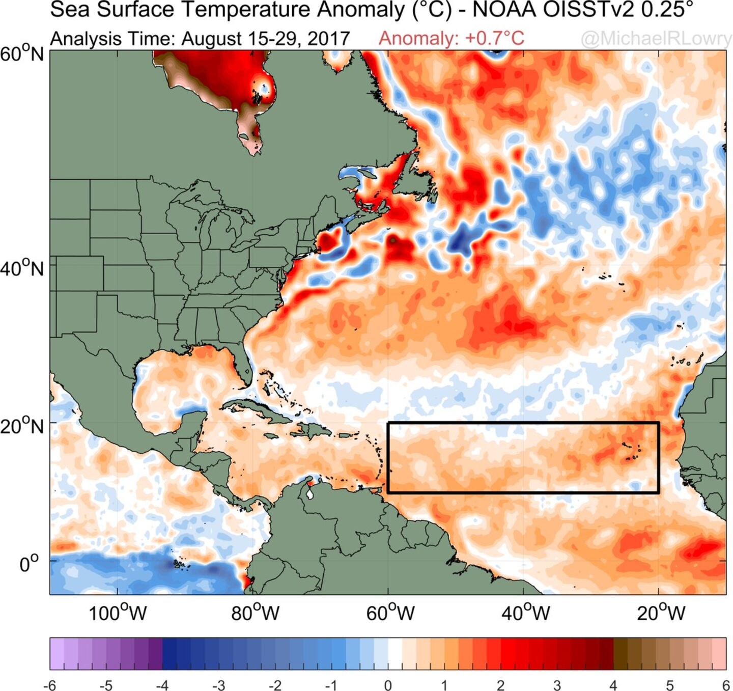
Very warm ocean water ahead for Irma:
1
Even more telling - the oceanic heat content showing a wealth of deep warm water over the SW Atlantic/Caribbean & Gulf of Mexico:

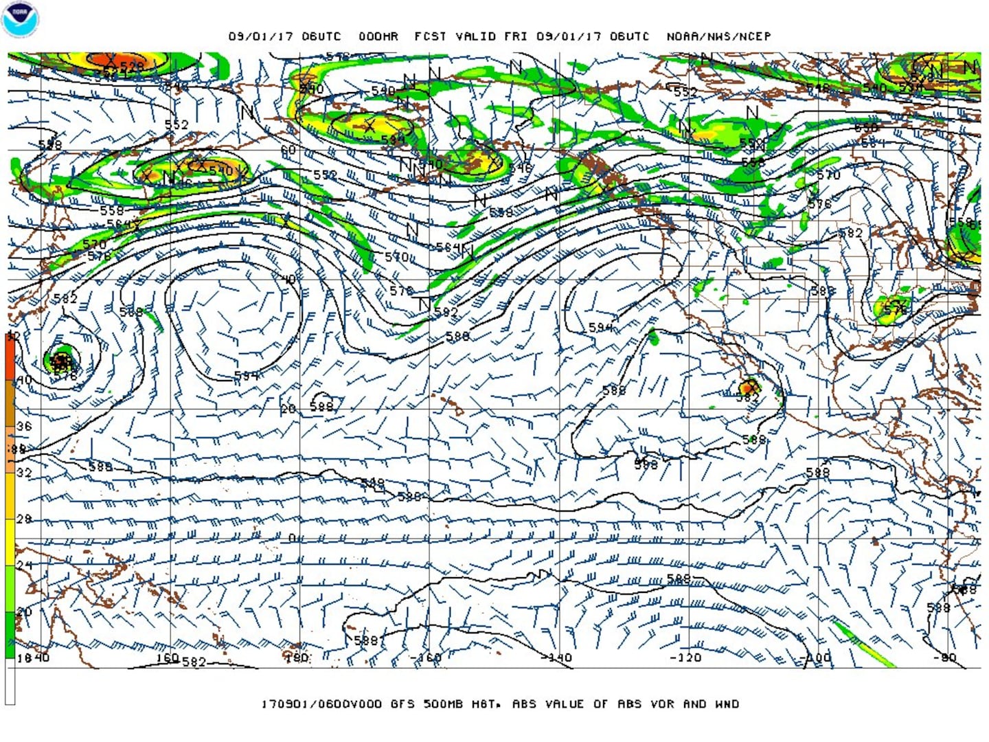
The Pacific typhoon teleconnection worked pretty well for forecasting "Irma" - it's lined up nicely so as to draw some parallels. The 500mb chart below from the GFS for the N. Pacific to the Northern U.S. shows trough, ridge, trough, ridge, trough - the last trough being over or near the Eastern U.S. (it's what's picking up the "Harvey" remnants). The W. Pacific trough is picking up typhoon "Sanvu" keeping the tropical cyclone very near or to the immediate east of Japan. This MIGHT be - & so far has been - an early clue that at least some semblance of troughing or alleyway will remain in place over or near the Eastern U.S. which ultimately draws Irma northward over the S.E. U.S. coast.
Satellite imagery below shows a band of clouds over the Eastern U.S./W. Atlantic - a weakening front that will be reinforced over the next couple days & is part of the weakness in the upper level flow that gradually pulls Irma northward....

Jose:
.... became a "major" hurricane but is feeling the effects of southwesterly shear... & will languish in the "backwash" of Irma for many days & brushed the Northern Lesser Antilles over the weekend including some of the same islands hit by Irma! I'm still not certain this simply stays out to sea so bears watching in the long run - 5-8 days - for a possible loop then turn more to the west. Indications are that "Jose" will turn northward about 300-500 east of Florida missing the Southeast U.S. coast but the upper east coast is not necessarily out of the woods yet.


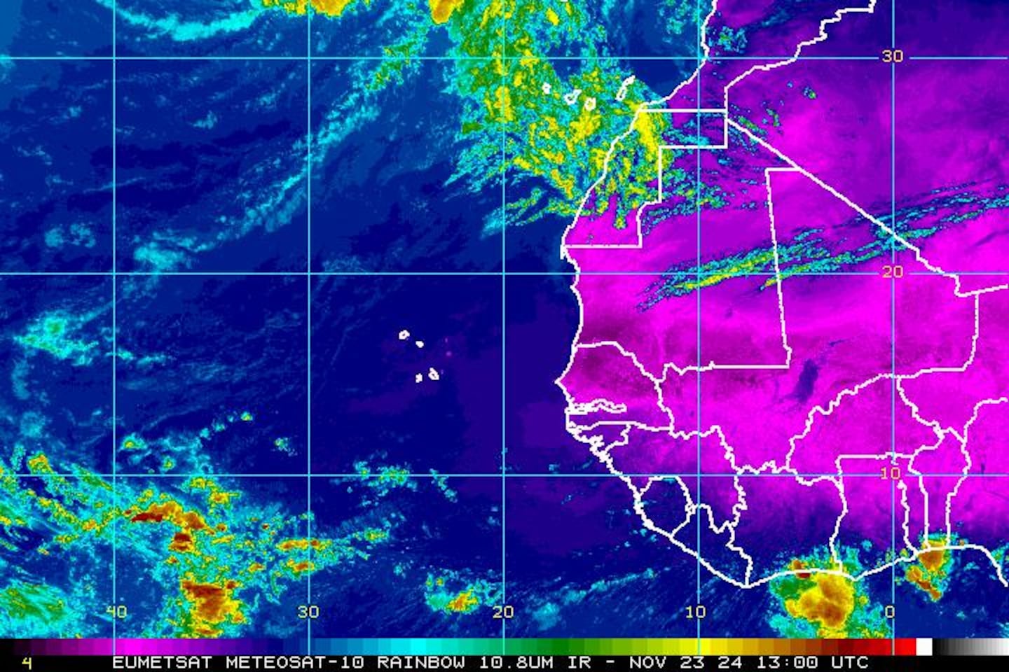
East Atlantic IR satellite shows another strong tropical wave which has a good chance to become a named storm(!):
Mid & upper level wind shear (enemy of tropical cyclones) analysis (CIMMS) - note how strong the shear is across the N. Gulf of Mexico, the north two-thirds of Fl. into the W. Atlantic which eventually will help shred Irma:

The main development region (MDR) remains above avg. temps. - in fact - only 2005 & 2010 were warmer. The deep warm ocean water can "energize" tropical cyclones:
SE U.S. surface map - cold front is part of the equation for where Irma goes....


Surface analysis centered on the tropical Atlantic:

Surface analysis of the Gulf:

Caribbean:

Cox Media Group


