JACKSONVILLE, Fla. — This morning we are tracking a dry morning commute with mild temperatures in the 60s and 70s.
- We will soar to the mid 90s once again this afternoon.
- Record: 94 - 1977
- Some wildfire smoke from Lafayette County, FL will blow into Lake City today and perhaps even produce smoky skies in Jacksonville this afternoon.
- Tracking showers and storms moving into SE Georgia late this morning and into the afternoon.
- A few storms may be strong, producing gusty winds. An isolated tornado cannot be ruled out.
- The bulk of the day will be dry in Jacksonville.
- A few late day showers or storms may sink south to just near or north of the I-10 corridor between 4 and 6 pm.
- Rain amounts near a half inch (+) will be common across south Georgia Thursday, with lower amounts for north Florida.
- The front will slow down and linger across our area this weekend, keeping a chance for showers and thunderstorms in the forecast through Monday until another front dries us out by Tuesday.
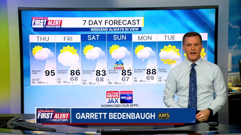
TODAY: Partly cloudy, breezy, and hot with afternoon/evening showers/storms. HIGH: 95 (Record: 94 - 1977)
TONIGHT: Mostly cloudy with a lingering shower early. Low: 68
FRIDAY: Partly cloudy, isolated afternoon shower/storm. 68/86
SATURDAY: Mostly cloudy, scattered afternoon storms. 68/83
MOTHER’S DAY: Mostly cloudy, a few afternoon storms. 67/85
MONDAY: Mostly cloudy, scattered showers/ storms. 69/88
TUESDAY: Partly to mostly sunny. 65/81
WEDNESDAY: Mostly sunny. 61/85
WATCH THE FORECAST | DOWNLOAD THE APPS
Follow Action News Jax Meteorologists on Twitter for updates:
Mike Buresh | Garrett Bedenbaugh | Corey Simma | Trevor Gibbs
ALLERGY TRACKER: See what the pollen counts look like in our area
LISTEN: Mike Buresh ‘All the Weather, All the Time’ Podcast
INTERACTIVE RADAR: Keep track of the rain as it moves through your neighborhood
SHARE WITH US: Send us photos of the weather you’re seeing in your area ⬇️


