Here’s what the First Alert Weather Team said you can expect for the First Alert Weather forecast:
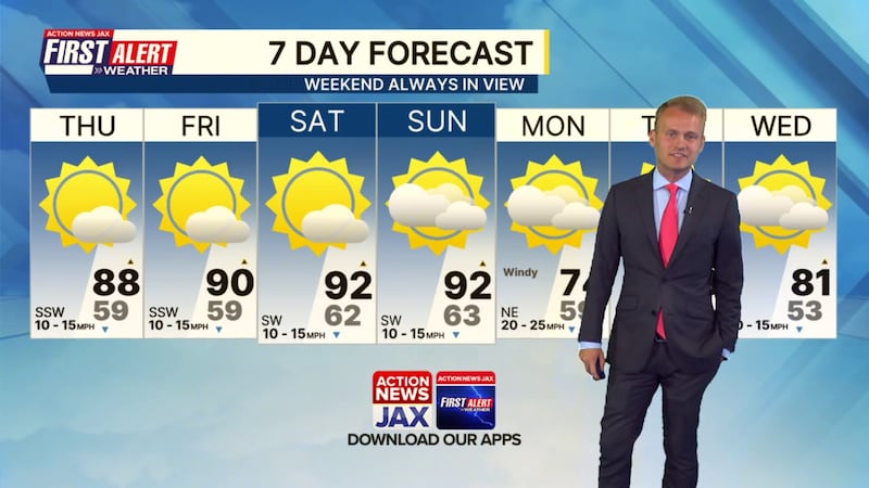
- A high risk of wildfires through the weekend but otherwise very nice weather, albeit quite warm. At least the humidity will be pleasantly low.
- Highs in the upper 80s to low 90s through Sunday will be near record highs.
- A cold front Sunday night may trigger a brief sprinkle or light shower, but no appreciable rainfall.
- Temperatures will be cooler to start the new workweek Monday with highs in the 70s and gusty wind out of the northeast.
WATCH THE FORECAST | DOWNLOAD THE APPS
TONIGHT: Clear. Low: 59
THURSDAY: Mostly sunny. High: 88 (record=90/1972)
THURSDAY NIGHT: Clear. Low: 59
FRIDAY: Mostly sunny. High: 90 (record=93/1967)
SATURDAY: Mostly sunny. 62/92 (record=94/1967))
SUNDAY: Partly sunny. 63/92 (record=92/1995). Sprinkle or light shower possible at night.
MONDAY: Partly cloudy, windy & cooler. 59/74
TUESDAY: Partly sunny. 53/78. Low 70s near the coast.
WEDNESDAY: Partly sunny. 53/81
Follow Action News Jax Meteorologists on Twitter for updates:
Mike Buresh | Garrett Bedenbaugh | Corey Simma | Trevor Gibbs
ALLERGY TRACKER: See what the pollen counts look like in our area
LISTEN: Mike Buresh ‘All the Weather, All the Time’ Podcast
INTERACTIVE RADAR: Keep track of the rain as it moves through your neighborhood
SHARE WITH US: Send us photos of the weather you’re seeing in your area ⬇️


