
Jacksonville, FL — “Talking the Tropics With Mike” - updated everyday during the hurricane season (through Nov. 30th)
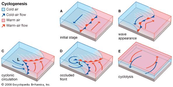
We’ve heard a lot about the “Bomb Cyclone” recently & especially the past week thanks to an intense ocean storm over the NE Pacific & a Nor’easter just off the New England coast (the week of Oct. 25th). Bombogenesis or explosive cyclogenesis as it is sometimes called is - quite simply - an intense midlatitude cyclone - or low pressure area. It’s not a new phenomenon &, in fact, has been occurring around the globe for as long as the Earth’s atmosphere has existed such as it does. It seems the term was first coined in about the 1940s and ‘50s becoming a more common term in the 1980s (yes - I studied this type of low pressure in college!).... & now during the times of social media, hype & hysteria - including the way over-used cliche “extreme weather”, it seems “Bomb Cyclone” has become the new “end of the world” when it comes to weather. And many news outlets love to use the term - with reckless abandon & without any context - for a headline, click bait or what’s called in the t.v. biz - a “tease”. Ugh. I’d like to think bomb cyclone is not being used to push an agenda or to try to substantiate a narrative, but I’m not so sure.
In any case, the definition of Bombogensis: a midlatitude cyclone that intensifies at least 24 mb / 0.71″ in 24 hours or less. Such a fast-to-intensify storm is most common over the world’s oceans & sometimes along coastlines but will occasionally occur over land including the Great Lakes region & even the land-locked Midwest (2010). Heavy rain, high winds, severe storms & heavy snow often result though the most recent New England Nor’easter was milder (was cut-off from the polar jet stream) &, therefore, was all rain. And bombogenesis should not be confused with the rapid intensification cycle (RIC) of tropical cyclones (tropical storms & hurricanes) - a completely different beast intensifying for very different reasons (most notable difference - no thermal change vs. a midlatitude cyclone with fronts, change in temps., strong upper level “energy”).
2010 NOAA satellite of bombogenesis near & west of the Great Lakes:
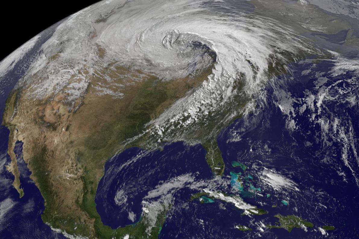
NASA satellite image of Nor’easter just off the coast of New England:

Rapid cyclogenisis satellite image from NASA - N. Pacific:

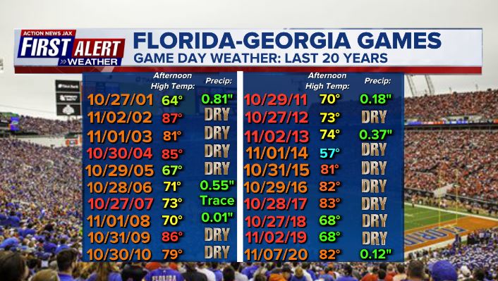
The “World’s Largest Outdoor Great Cocktail Party” is upon us with a return of the large crowds we’re so used to. The weather looks nice & even fall-like for Sat., 10/30. Going back to 2001, the avg. high temp. on game day has been 75 degrees but as cool as just 57 in 2014 & as warm as 87 degrees in 2002. There has been measurable rain on only 6 days of the big game in the last 20 years. On the chart below, orange colored dates = Gators win, red colored dates = Bulldogs ‘W’.
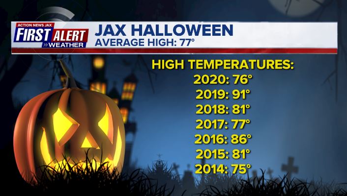
The day after Fl./Ga. is Halloween. Recent years have been quite warm with an avg. high of 81 degrees since 2014 including the hottest Halloween on record (& latest 90 degree day in Jax) - 91 degrees - in 2019. Much more comfortable this year!
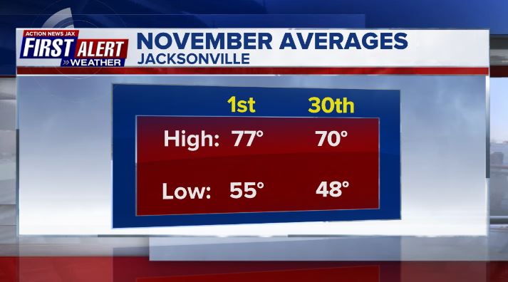
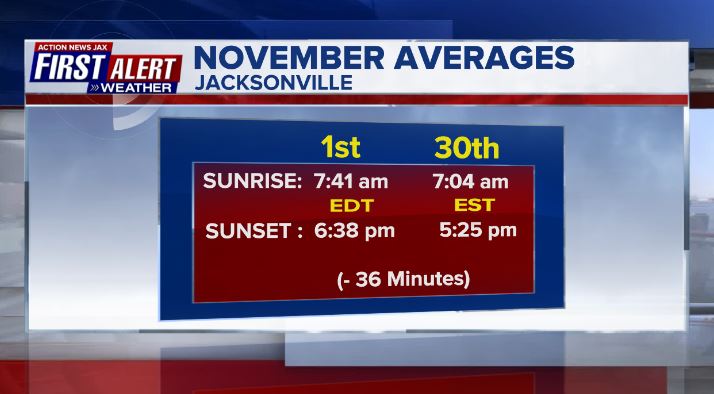
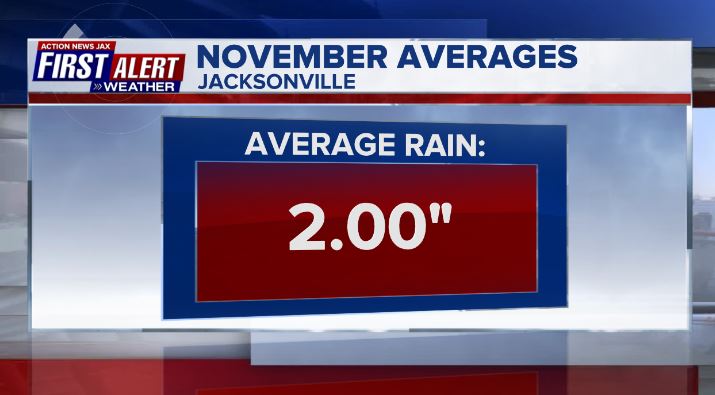
And - lastly - we turn the calendars to November. We usually start to see our first true, longer-lasting cool spells - that about once every 5-10 years - can include our first freeze... as well as one of the driest months of the year. The averages at JIA:
©2021 Cox Media Group


