
Oct. 14, 2018 — Post storm photos & video ** here ** ............ video courtesy "Tornado Trackers" ** here **... & from Tyndall Air Force Base ** here ** ..... summary from the Tallahassee N.W.S. ** here **... "Buresh Blog", Podcast - a visit to Ground Zero nearly 4 months later.
It's not hyperbole to say Michael will "go down in history". The hurricane is a once in a generation landfall for where the storm took aim, the most powerful hurricane to ever hit the Florida Panhandle. There will be storms as strong - or even stronger within the next 100 years - but not likely to hit the exact same area.
So here's my personal recollection of Michael - forecasting the monster, it's devastation & some personal observations. Some of this will be based on fact, some on opinion.
Wed., Oct. 10th:
IR satellite view of move to the Panhandle:
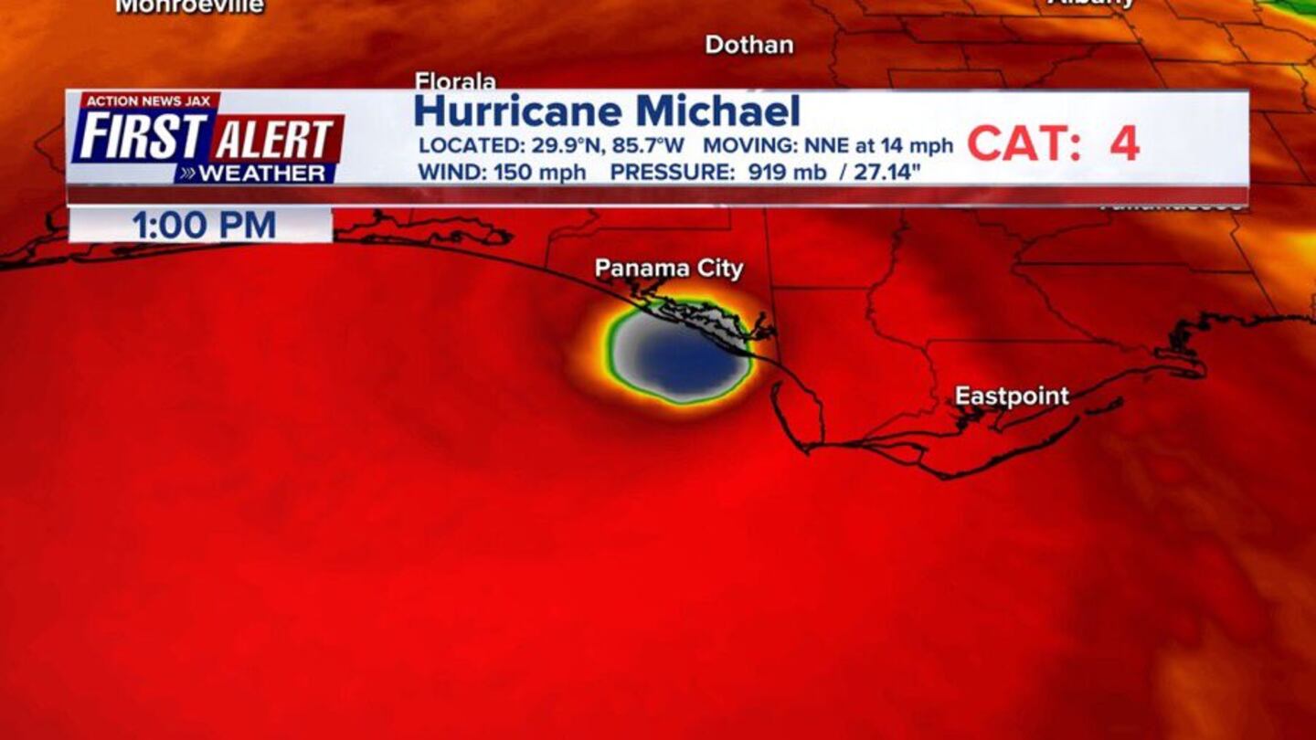
Visible satellite view of landfall:
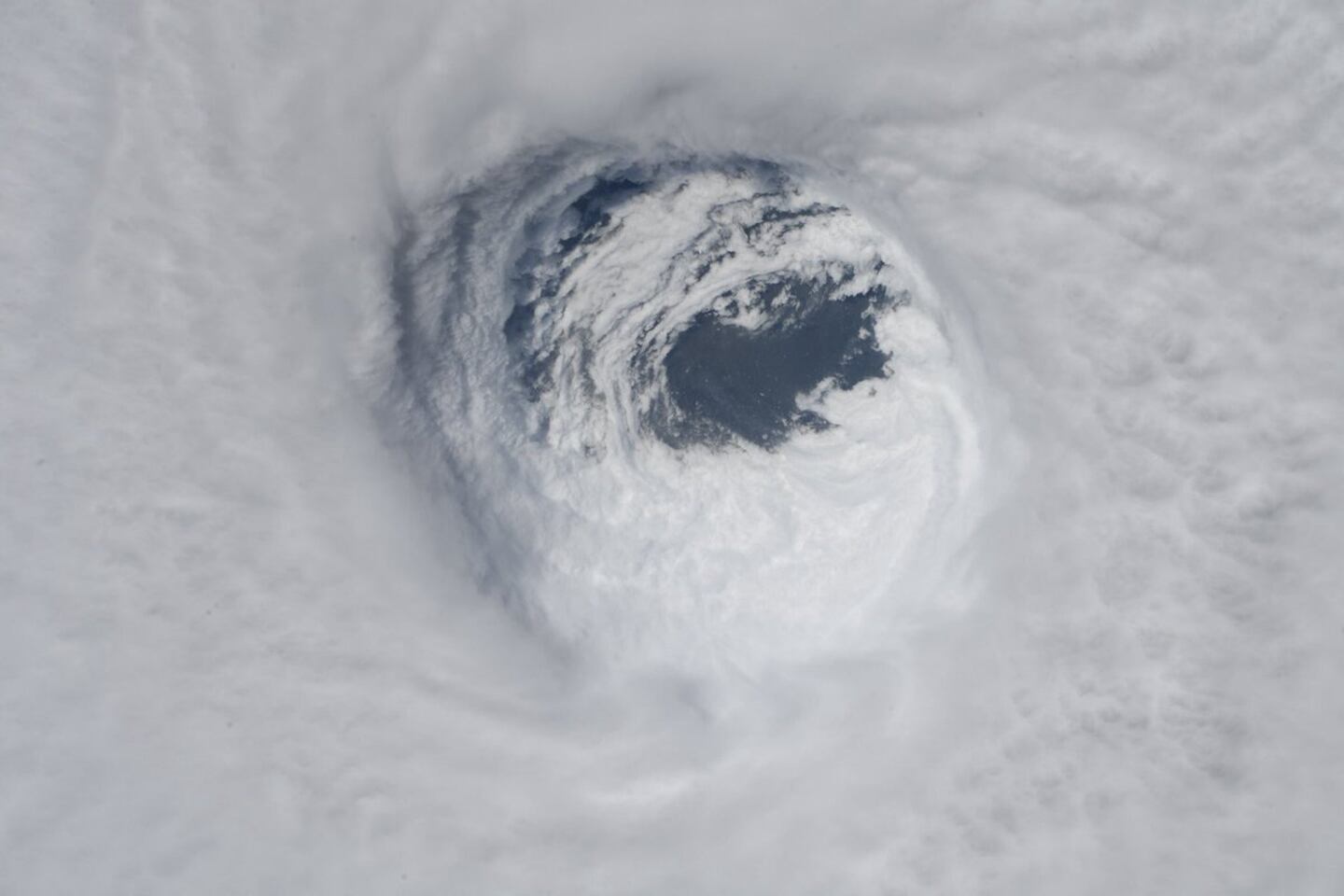
Zoomed in image of Michael's eye from GOES-16 visible satellite:
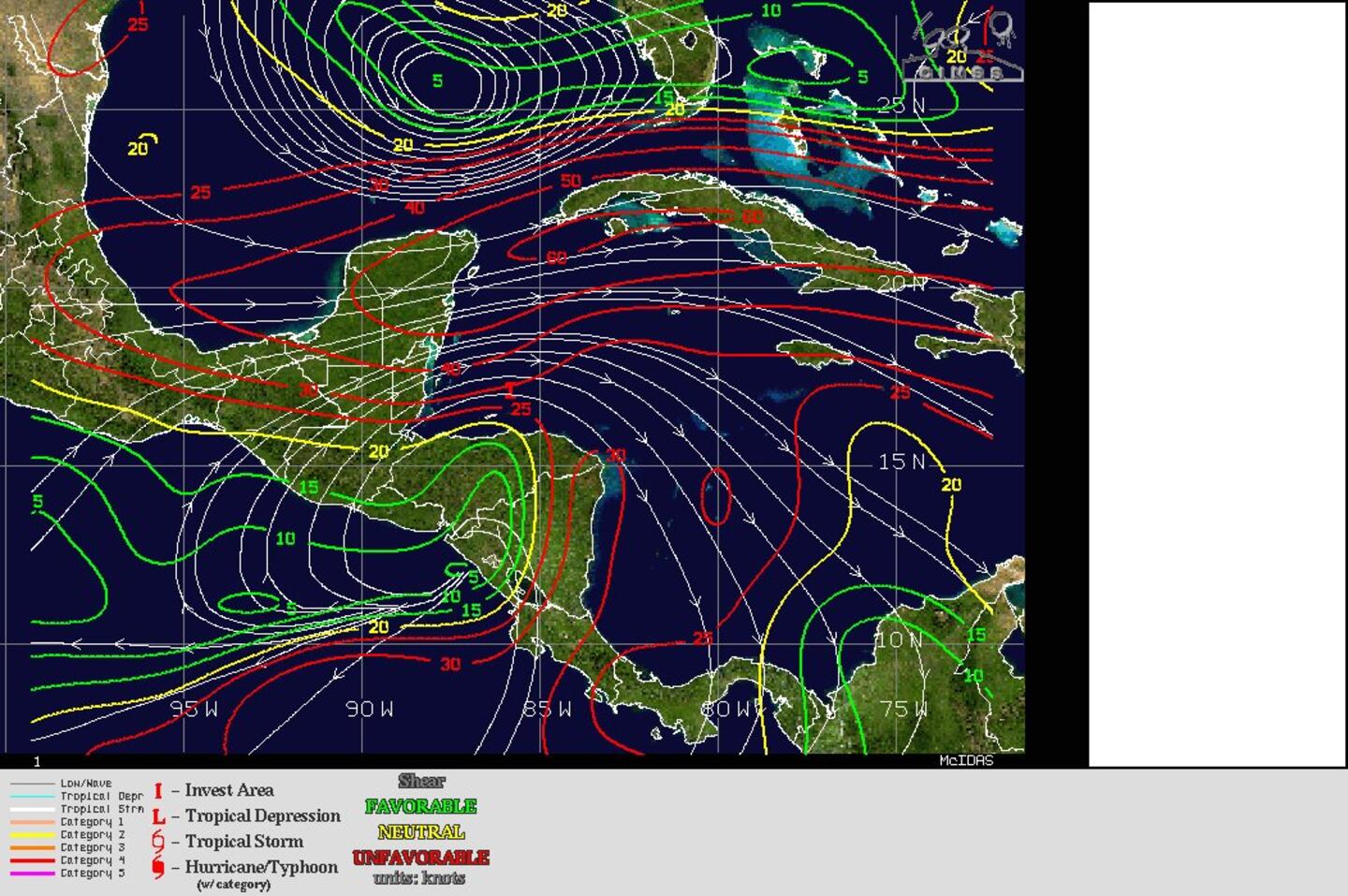
From CIMMS (Integrated Microwave Imagery shows the incredible intensification):

The first sign of tropical trouble over or near the Caribbean began to rear its ugly head as early as mid to late Sept. (keep in mind that landfall was on Oct. 10th). A combination of large scale + a few small scale atmospheric & oceanic conditions gave us a heads-up that the tropics would probably "come alive" the first two weeks or so of Oct. This combination included: a large ridge of high pressure at higher latitudes extending east/west from across the N. Atlantic... generally lower pressures at more southern latitudes including the tropics & subtropics. a MJO (Madden-Julian Oscillation) pulse that would result in general upward motion which is often more favorable for tropical development very warm ocean water... the delayed development of a possible El Nino over the equatorial Pacific.
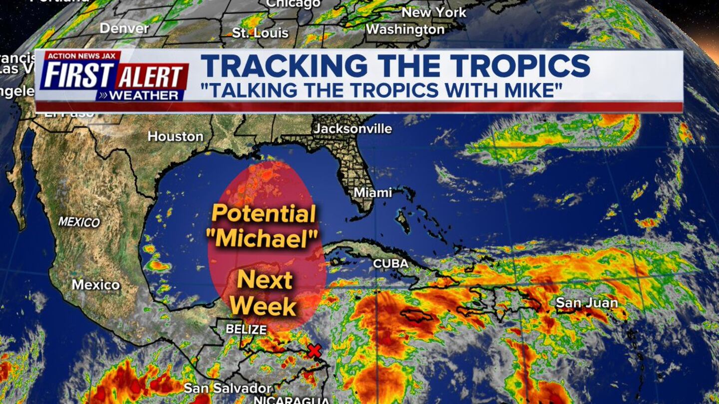
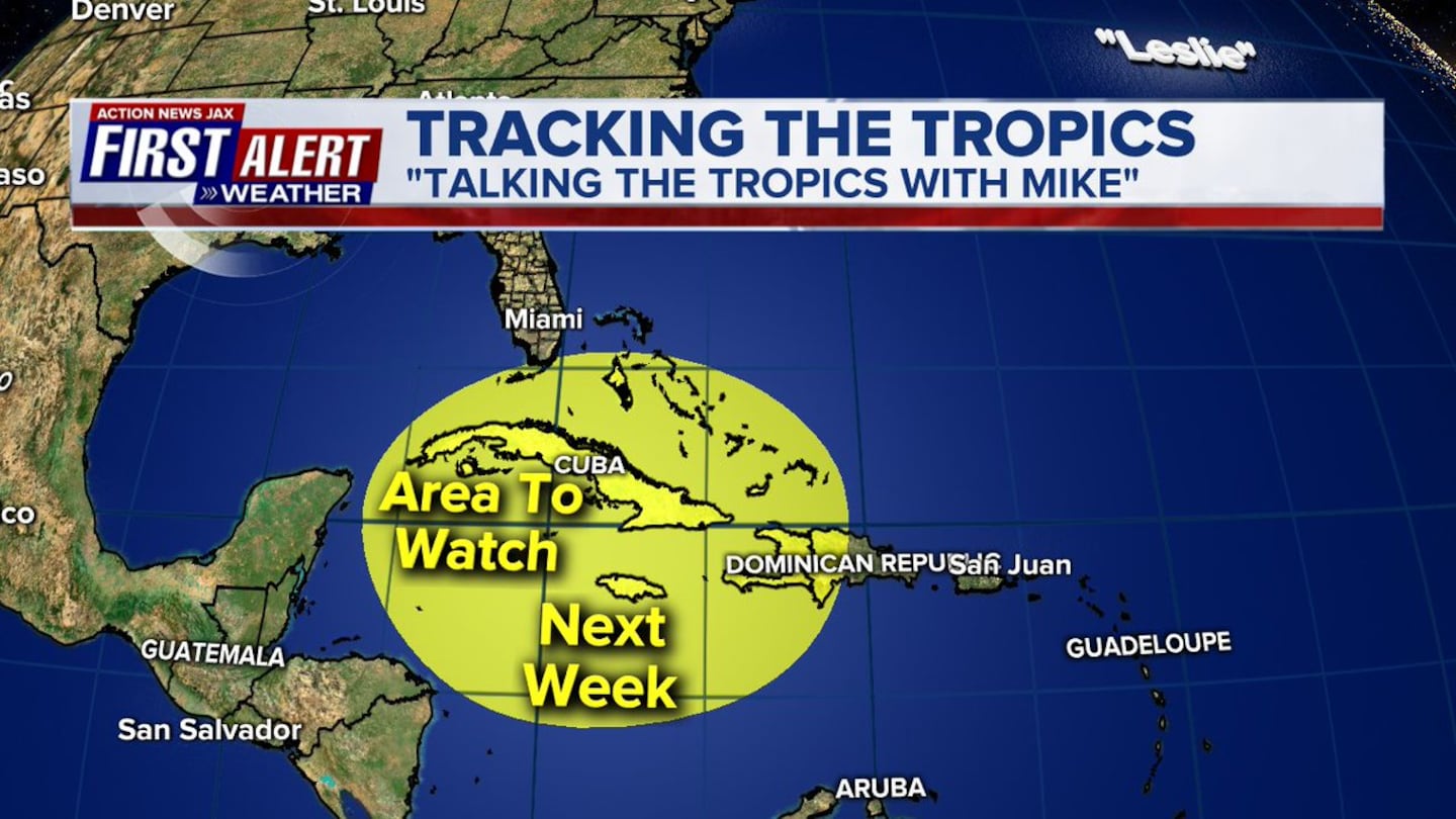
From my "Talking the Tropics With Mike" (TTTWM) entry on Sept. 18th - 22 days before Michael's landfall - as hurricane Florence made landfall in N. Carolina: "Another area to watch in the long term - late month - may be over the Caribbean &/or Gulf of Mexico."
10 days later on Sept. 28th: "While tropical development could occur just about anywhere, it would appear we especially need to be vigilant of the Western Caribbean &/or Gulf of Mexico from approximately Oct. 5 through the 15th."
Then 1 week - 7 days - before landfall on Oct. 3rd: "Clusters of strong convection persist over the Caribbean. Broad low pressure has developed, but the t'storms lack organization & there is a fair amount of mid & upper level shear at the moment. Tropical development over/near the Gulf, Caribbean &/or SW Atlantic appears probable next week but the end result is still - as one would expect at this early juncture - far from certain. Long range global forecast models have at times "lost" this system. I would expect models to become more consistent in developing this potential tropical cyclone in the coming days."
THE BIRTH & MATURATION OF MICHAEL:
On Mon., Oct. 1st - a day that I was not working on air - First Alert Broadcast Certified Meteorologist Garrett Bedenbaugh wanted to go to air with a graphic highlighting the tropical area of concern. We discussed the pattern & agreed to shade an area of the Caribbean/SW Atlantic & Southeast Gulf of Mexico.
0
About 24 hours later on Tue., Oct. 2nd - as seen above - the National Hurricane Center delineated essentially the same area - a little smaller & a focused a little farther west. The % for development at the time was less than 20%. I don’t “do” %’s for this very reason - it can be misleading. I was confident of development & - to me - saying “this will develop” is more valuable & memorable for the consumer than a low percentage. Now - don’t get me wrong - I understand why the best hurricane forecasters in the world - at NHC - use & believe in probability forecasts. But my own personal experience tells me differently. People are more likely to pay attention - & hopefully PREPARE - if they are told something is going to happen vs. a 10 or 20% chance of something happening. For example: if there’s a 20% chance of rain, you probably feel like you won’t need an umbrella.... but if you’re told “it’s going to rain”, you will most likely grab your umbrella.
In any case.... by late week - on Oct. 5th - it was very obvious that a tropical cyclone was going to develop. I sent an email to our station managers Fri. evening alerting them to the potential. But at this time, there was still "only" a 60% chance of development according to the NHC. By Sunday morning, the 7th, it was just a matter of time before there would be tropical development. NHC had deemed the low pressure area just off the coast of Central America as tropical depression #14. In my "Talking the Tropics With Mike" blog midday Sunday: "Michael looks to be a fairly swift moving tropical cyclone which means dangerous impacts could extend well inland. Everyone from Florida to New Orleans should "hurricane prepare"..... & depending on where landfall is.... flooding & tornadoes could occur far inland over parts of Alabama, Ga., Fl. & the Carolina's (potentially bad news for Florence - wary Carolina residents)".
By 1pm (the 7th) the depression was upgraded to tropical storm "Michael". And despite battling a good deal of west to east shear - as high as 30-40+ mph(!) - Michael slowly but steadily organized & strengthened. This organization - including pulses of very strong convection (t'storms) during which the center "jumped" around attempting to set up camp underneath the strongest, most persistent convection - continued rather methodically through Monday. I pointed this out Sat., the 6th in "TTTWM": "Shear relaxes for a time over the Central Gulf - & when combined with better upper level ventilation - there is concern for fairly rapid strengthening once at a more northern latitude over the Gulf".
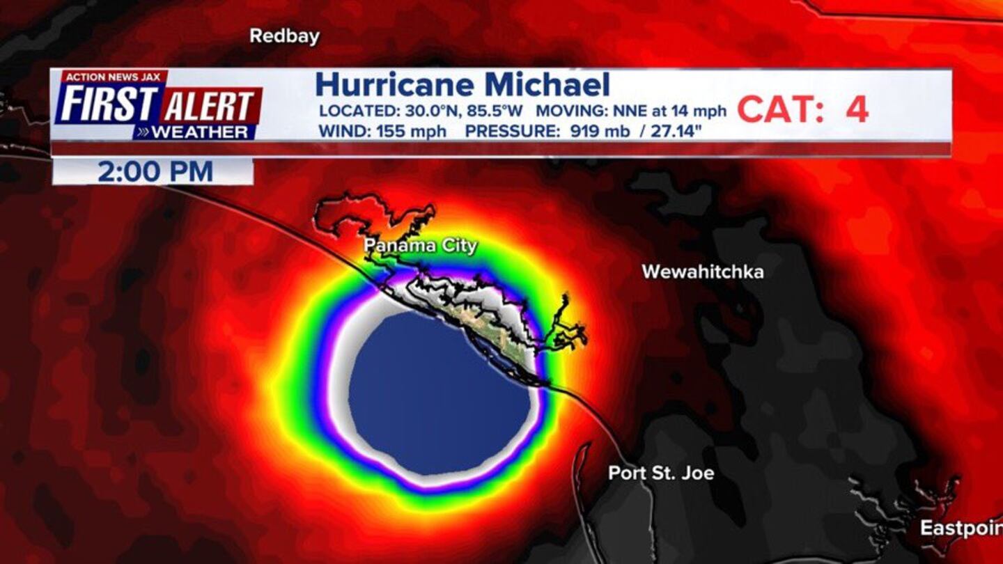
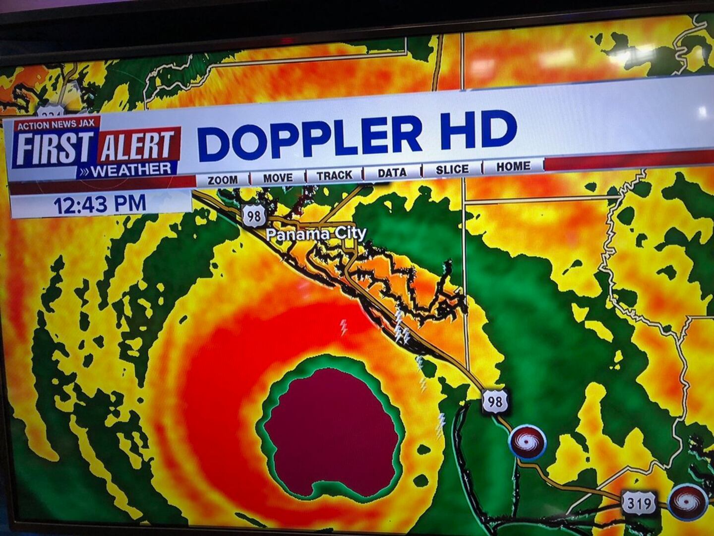
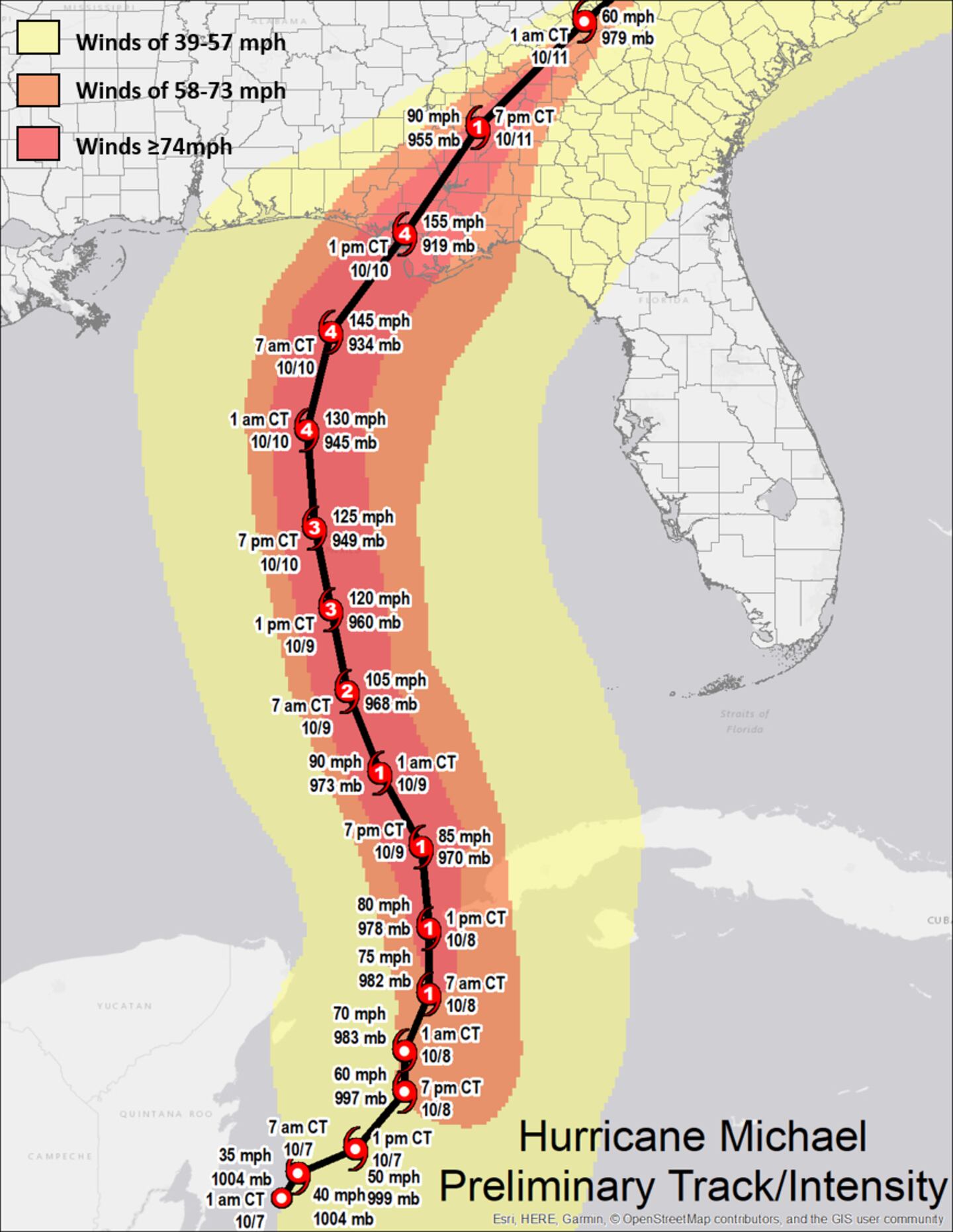
By Mon. night (the 8th), a central core had become well established & Michael became a hurricane though was still somewhat disorganized. Through Tue. & Tue. evening, explosive t’storm development around the center continued virtually unabated & by midnight Tue./early Wed. morning, Michael was undergoing a rapid intensification cycle (RIC). This cycle continued right up through landfall at 1:55pm EDT Wed., Oct. 10th helped out by a mix of a nearly ideal environment consisting of:
* very warm ocean water to a deep depth...
* weakening shear offset by the general heading of Michael to the north...
* & excellent upper level ventilation helped out by strong high pressure to the northeast combined with a strong trough of low pressure approaching from the west.
1
Oct. 6th shear analysis shows less shear over the Northern Gulf:
European forecast model (500 mb) from Oct. 5th for Oct. 9th shows the two big "players" involving Michael's movement - upper level ridge W. Atlantic & strong upper level trough Western U.S.:
The 53rd Weather Reconnaissance Squadron flew hurricane Michael from Oct. 7, 2018 right up to landfall on the 10th. This photo is from Wed. morning’s (10th) reconnaissance mission. (U.S. Air Force photo by 1st Lt. Garrett Black, 53rd WRS):
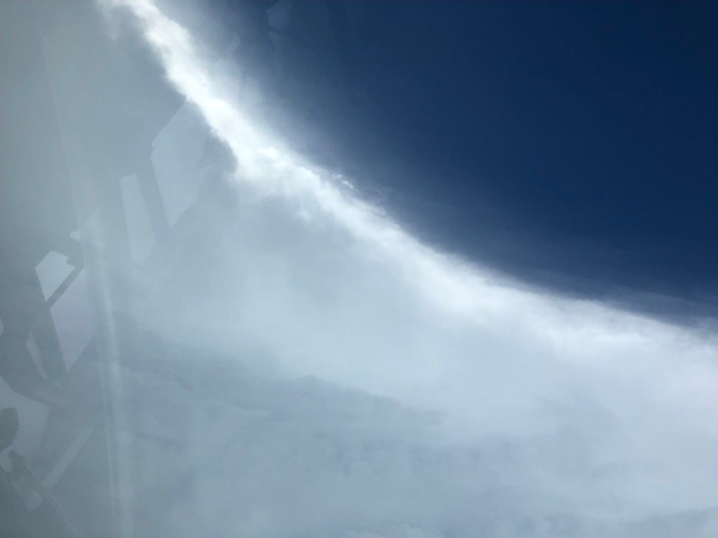
Fascinating photo below from "Basehunters Chasing": "Oct 10, 2018 - Tyndall AFB, FL - 14 mm wide angle shot standing in the eye of Hurricane Michael with full sunshine. We heard thunder a couple times in the eyewall and could hear the roar of the wind around us at times. Very surreal experience."

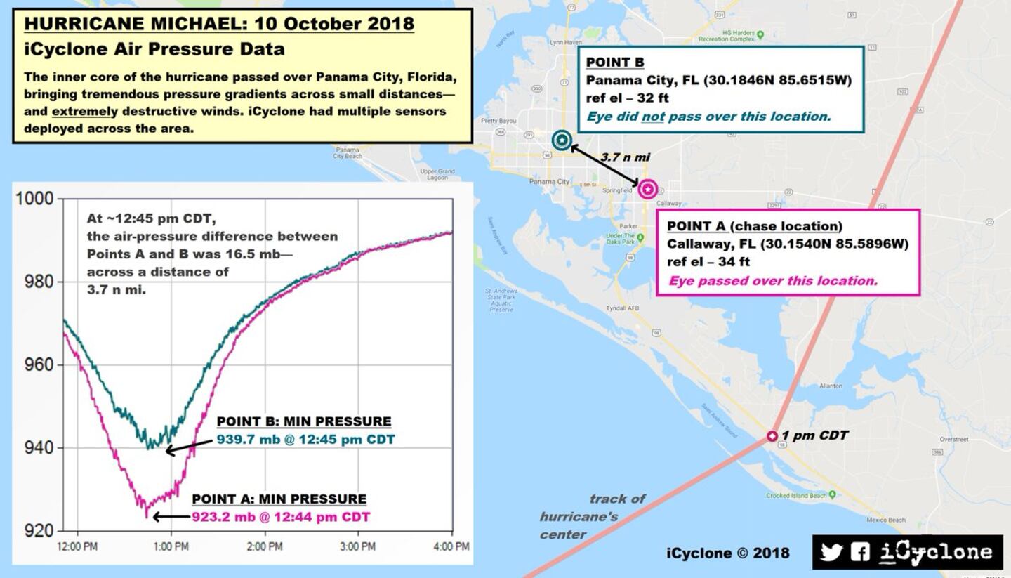
Graphic below posted by Josh Morgerman, iCyclone:
"
"
FORECAST MODELS:
Forecast modeling was really good in spots & really bad at times - about what one would expect because - after all - they are just forecast models(!) of a very chaotic atmosphere. The American model GFS did a fine job of sniffing out possible development well in advance of true formation. However, there was about a 3-4 day period where the GFS “lost” any kind of storm at all. And, of course, there was a big range in where any storm might go. But the model eventually did begin to catch on to a system developing & getting pulled north by a deep upper level trough which is a typical pattern with mid to late season tropical cyclones. By Fri., Oct. 5th the GFS was consistently back “on board” with development showing pretty fast movement northward anywhere from Pascagoula to the Fl. Panhandle. The GFS ended up being excellent on speed & pretty darn good on location rather far in advance - at least during the weekend before the big landfall. The European model had some problems of its own. The model did not catch on right away that tropical development would occur but did start to consistently show such by about Wed., Oct. 5th. There were a few model runs that pulled the storm east of Fl. but the ensemble - all of the models averaged together - showed either a Fl. or Gulf coast storm. This model was one of the more intense solutions but was also quite consistently too far east & much too slow generally showing any landfall to be late Thu. if not Fri. - a full 24+ hours behind the GFS & what turned out to be reality. The UKMET model is often my “go to” solution as a good compromise between the GFS & European model. The UKMET also showed consistent tropical development by Fri., Oct. 5th - was very strong... about Wed. night/early Thu.... but quite a bit farther east than most of the other modeling - in fact, as far east near Tampa. So when all was said & done.... you can see that a combination - or average (consensus) - of these 3 models would have yielded a pretty close forecast on what actually happened: a near Cat. 5 landfall Wed. afternoon on the Fl. Panhandle.
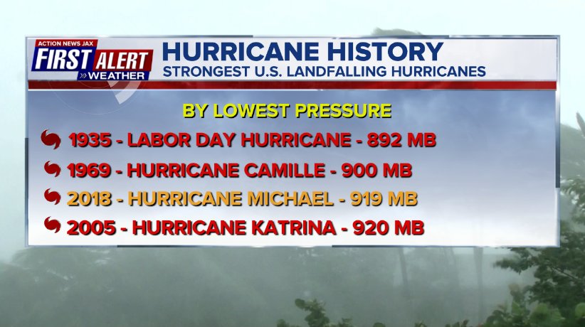
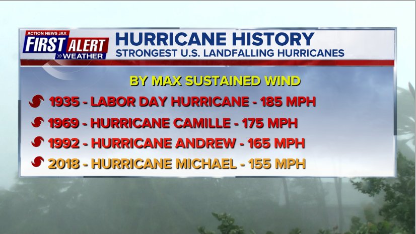
HISTORICAL NOTE:
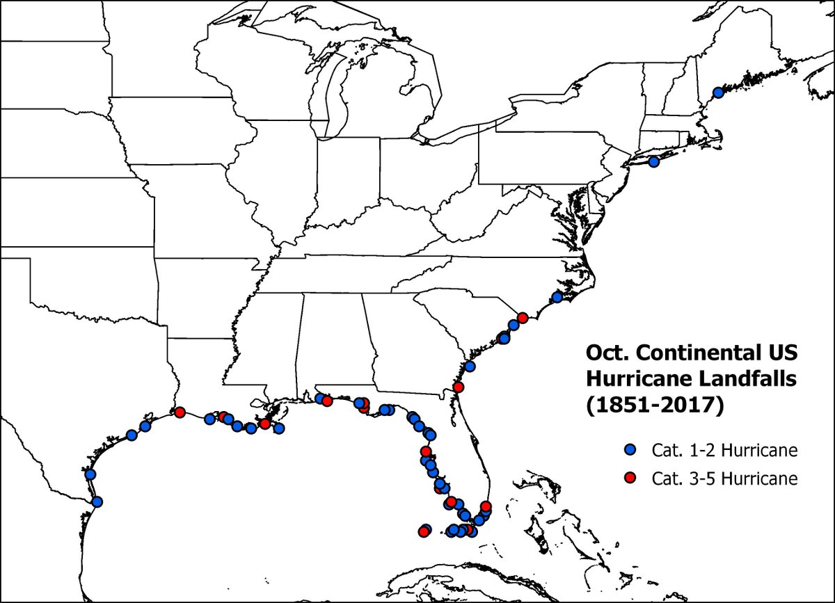
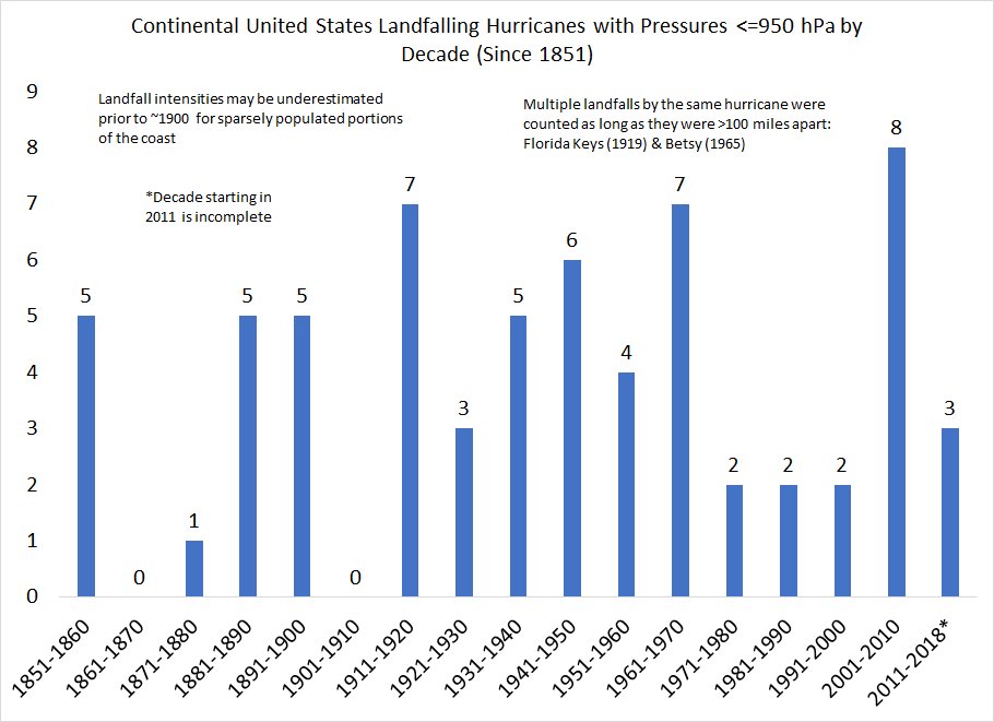
Climatology alerted us to beware of Michael & possible serious mischief. In the "Buresh Blog" posted Wed., Oct. 5th, I pointed out Matthew in 2016, Joaquin in 2015, Sandy in 2012, Wilma in 2005, Mitch in 1998 & Opal in 1995. It turned out Michael would be more intense than any of these Oct. predecessors. The map below courtesy Dr. Phil Klotzbach shows Oct. U.S.hurricane landfalls going back to 1851.
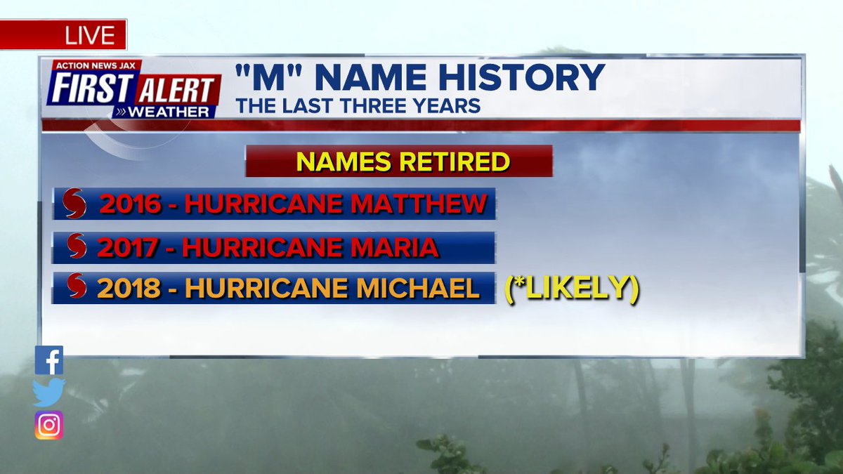
Recent 'M' names have been nasty to say the least:
MY FORECAST:
The forecast was not perfect, but I think - in fact, strongly believe - it was helpful & effective. There certainly was lead time for people to prepare & evacuate - in absolutely no way, shape or form did "Michael come out of nowhere". I wrote "hurricane prepare" Sun., the 7th & as late as sunrise Wed. morning - the day that will live in hurricane & Panhandle infamy - I said & wrote "if you have friends or loved ones that live in the Central Panhandle - tell them to get out". While time was running out by early Wed., a simple get in your car & drive north 20-30 miles or more if possible was still very do-able & would have been life saving. I had forecast an east jog or move upon approach to land. This did turn out to be the case though there still were occasional "spurts" north & even east from time to time right up to - & beyond - landfall. These typical track wobbles - in the end - helped pound Panama City with the western eyewall but helped to somewhat spare Tallahassee. My expectation for some in-close eastward movement was based on friction from land... the approach of the strong upper level trough.... & the very warm ocean water of the NE Gulf. I had seen - & taken note - of a similar path & behavior by Cat. 3 hurricane Ivan which hit the Panhandle in Sept., 2004.
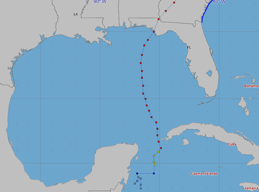
So I did generally - but very carefully - downplay impacts for Jacksonville/NE Fl./SE Ga. though always emphasizing (& realizing deep down) the potential danger of so-called fringe effects including isolated tornadoes & gusty winds not to mention the pitfalls of a blown forecast which - I'm pleased to say - did not happen. Never did I expect water to be a problem whether storm surge or fresh water (heavy rain) despite strong southerly flow right up (north) the St. Johns River which did cause some minor flooding for downtown Jacksonville but nothing like Irma last year.
IMPACTS:
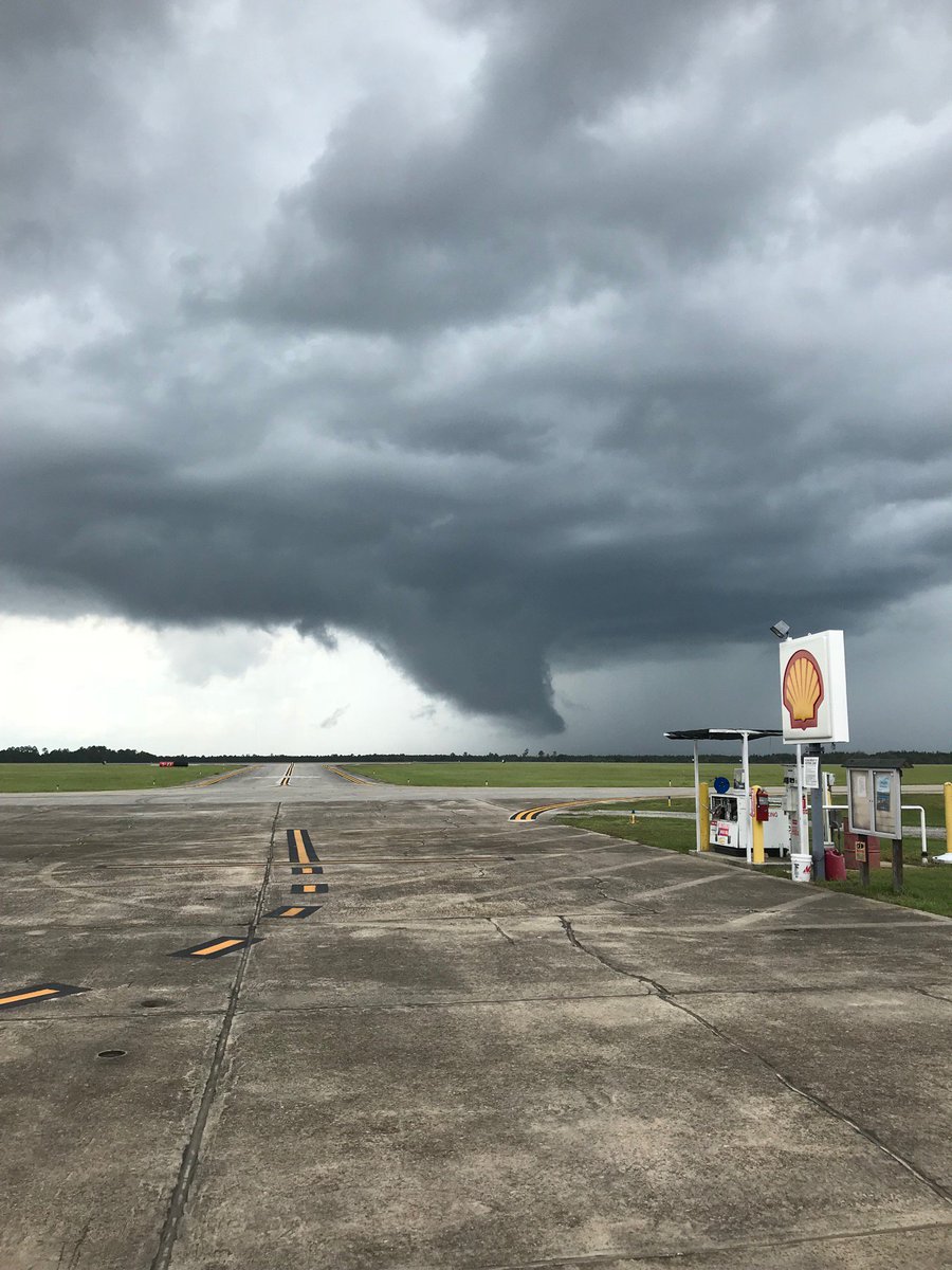
Jacksonville & surrounding areas did indeed only feel the fringe effects of Michael in the form of gusty winds, isolated tornadoes & heavy but brief rain. At least one tornado touched down in Western Clay Co. with a number of photos/videos. The same northward moving storm produced a long-lasting funnel cloud over Western Duval Co. that crossed I-10 as video taped by one of our Action News videographer/reporter duos. Wind gusts with several of the t’storm clusters/bands reached at least 50 mph. Gradient winds from Michael itself Wed. night into early Thu. were sustained at 25-35 mph over SE Ga. closer to the center with guts of 40-55 mph vs. 10-20 mph over NE Fl. with gusts of 30-40 mph. The southern - or bottom - portion of a landfalling tropical cyclone has a tendency to decay the fastest because dry continental air is easily wrapped into the storm from the north &/or west. Michael was no exception so SE Ga. & NE Fl. benefited from this dry air as early as mid evening Wed. which cutoff any additional rain or storms.
Clay County tornado east of Highway 301 north of Keystone Heights:
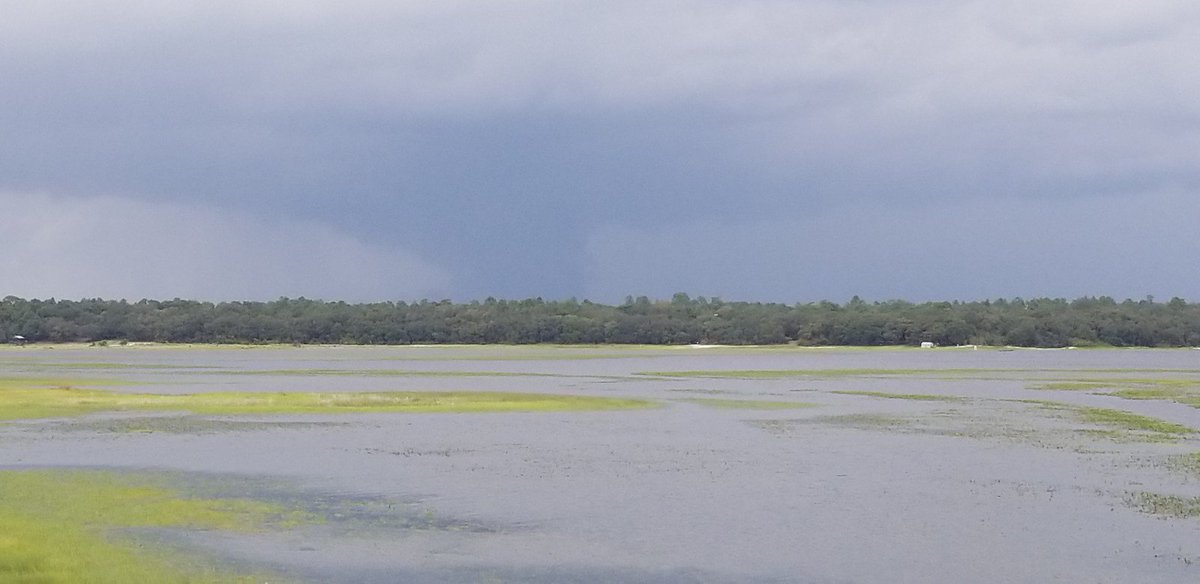
Funnel cloud over Clay County looking north from Keystone Heights:
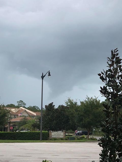
Funnel cloud near Palm Coast, Flagler Co.:
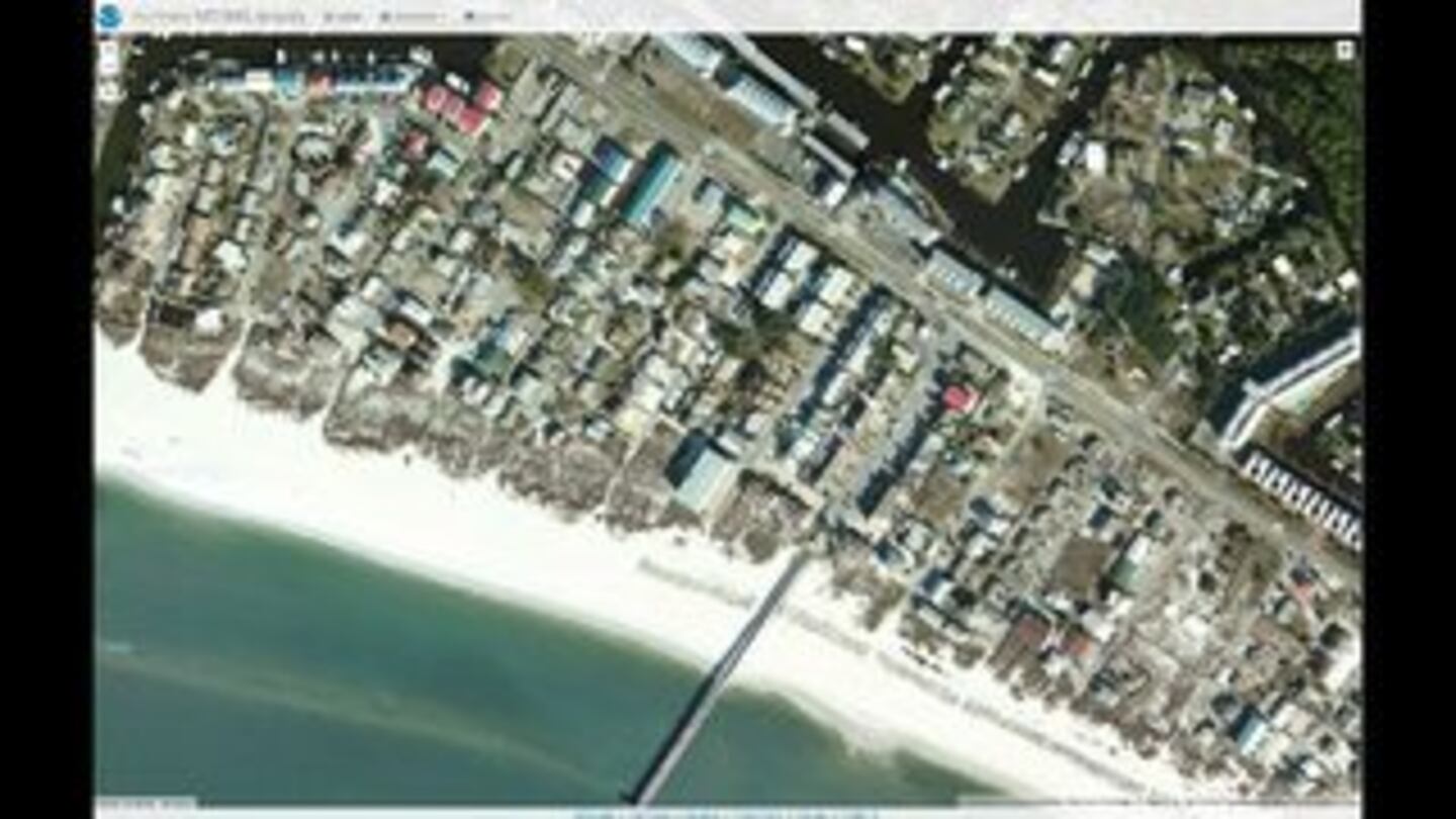
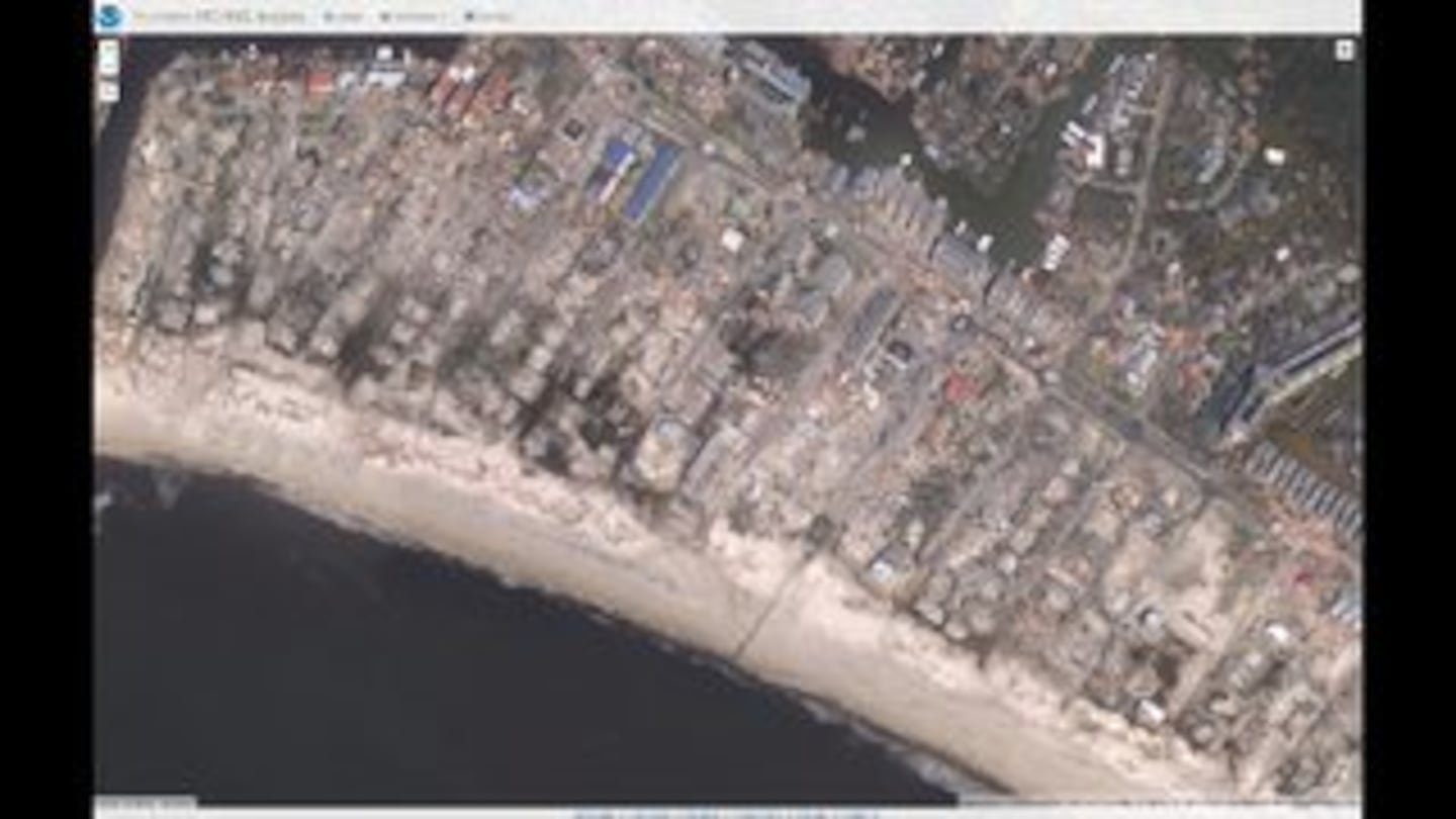
Michael's wave action & storm surge cut right through the St. Joseph Peninsula in the Panhandle (satellite image courtesy Tallahassee N.W.S.):

Image below from the Florida Department of Agriculture & Consumer Services shows the tremendous tree damage:
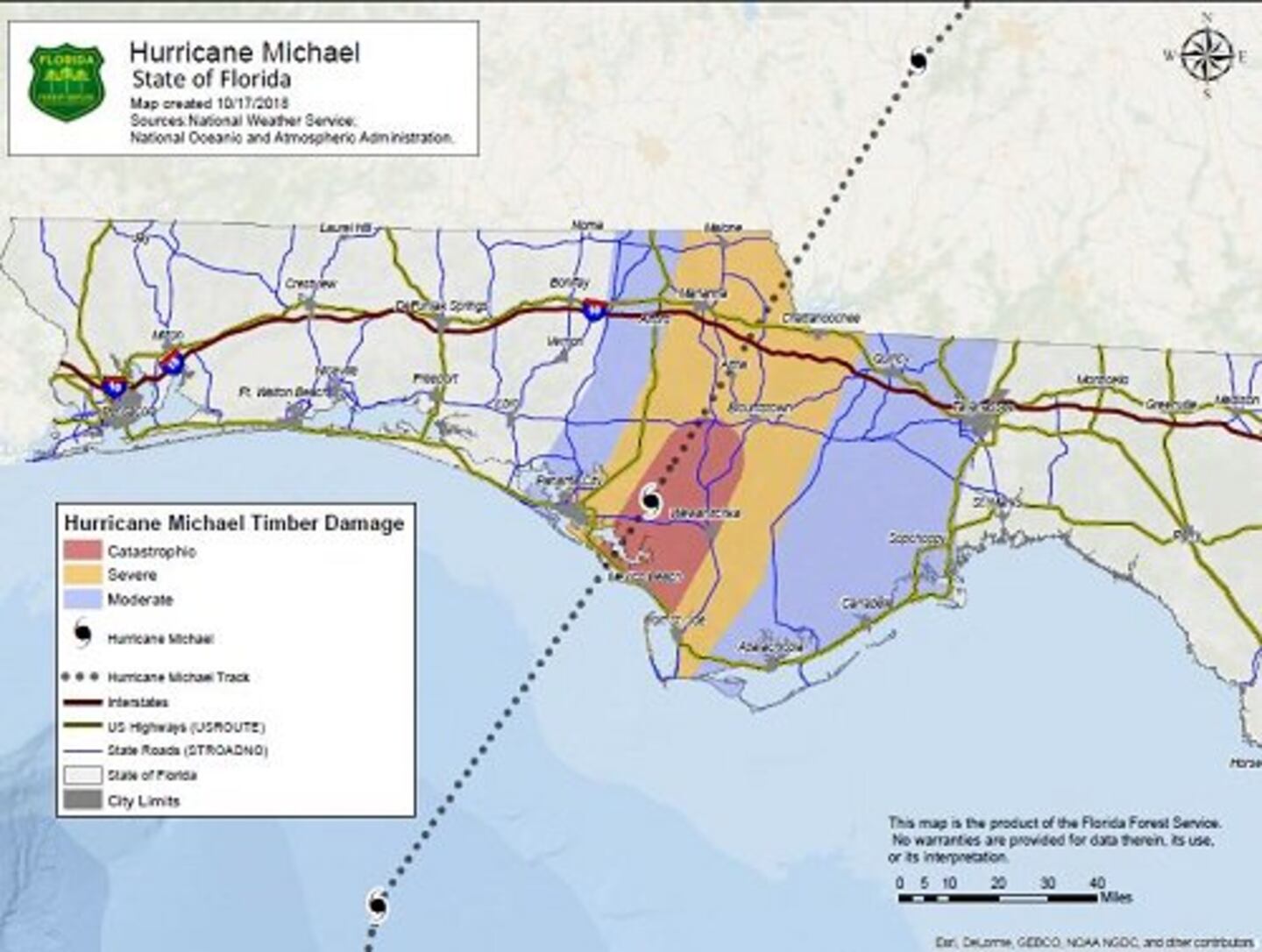
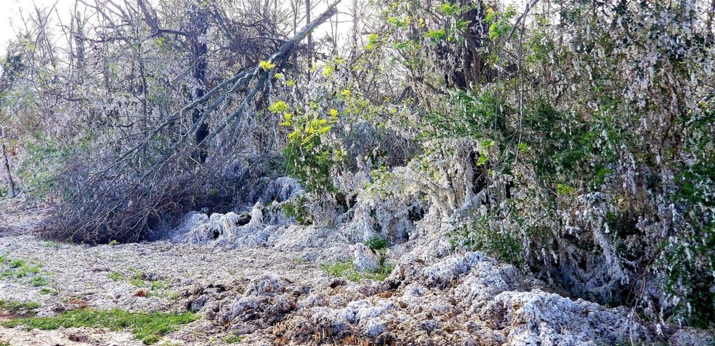
Photo below from Pete Miller - cotton field damage resulted in a landscape that looked like the ground was covered with snow:
CLIMATE CHANGE:
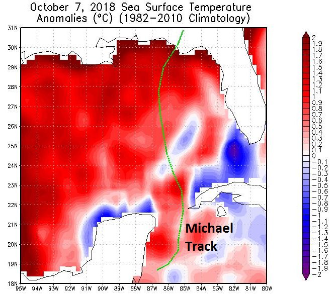
Let me get this out there right away(!): the earth IS WARMING. Now let me emphatically say this: Michael developed within an environment ripe for formation in which several seasonal factors came together to produce a powerful hurricane. Without as few as one of the key ingredients, Michael is most likely not the monster it became. The monster Michael was as likely to occur in ... say.... the 15th Century as the 21st Century ... or somewhere in-between.... pre-industrial as well as post-industrial. Michael was a product of unique but certainly not unheard of ingredients coming together at the right - or shall we say wrong - time to produce a massive hurricane. Ocean water was warmer than avg. by about 1 - 1.8 degrees F. Somewhat significant but not remarkable. More importantly the water was warm to a deep depth. Mid & upper level shear was seasonably strong initially but relaxed with time. An approaching upper level trough helped push the jet stream farther south - something that’s very common in Oct. when the N. Hemisphere starts to transition from summer to autumn. Oct., after all, often produces a secondary peak in the hurricane season as well as a mini severe convective period at mid latitudes. The approaching upper level trough acted to “ventilate” Michael - divergence aloft - which aided the t’storm updrafts. This recipe cooked up a powerful hurricane that lead to the worst possible outcome: an intensifying severe hurricane that was accelerating upon approach to land. Image below from Dr. Phil Klotzbach showing Gulf sea surface temp. anomalies:
Dr. Phil Klotzbach U.S. landfalling intense hurricanes since 1851 - arguably no significant statistical trend over the last century & a half:
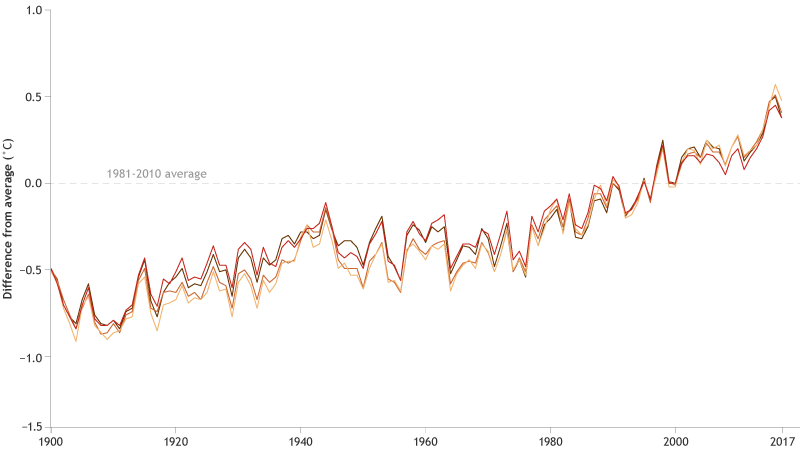
From Climate.gov - upward trend very apparent since 1980:
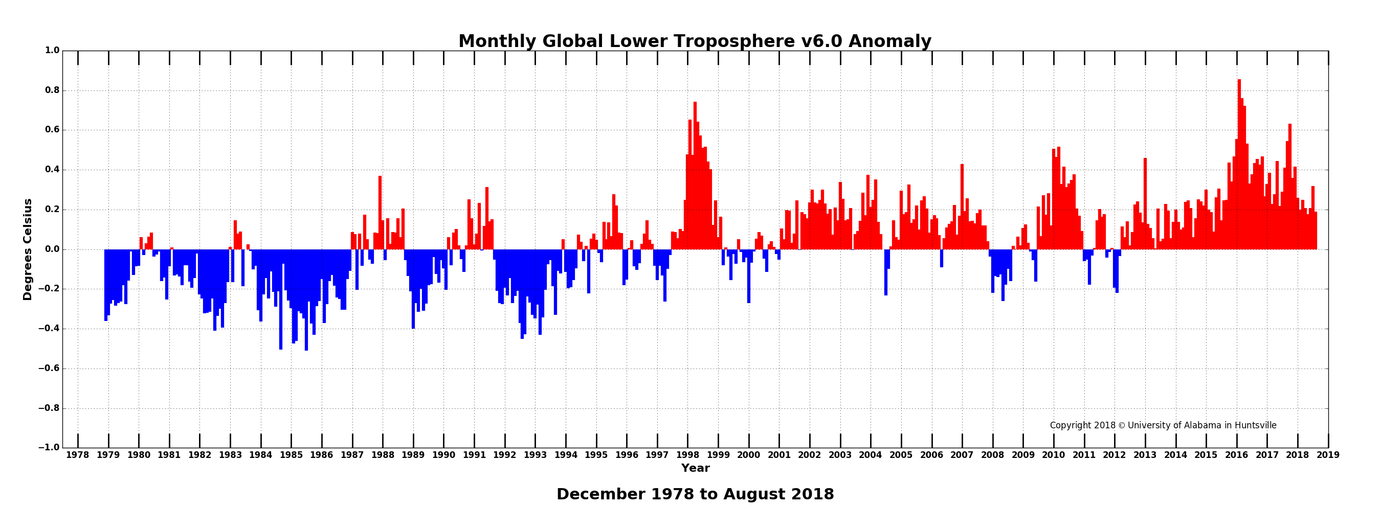
University of Alabama, Huntsville global temp. report:
FIRST ALERT WEATHER TEAM:
A whole lot of sleepless hours & more blood, sweat & tears than you probably realize go into trying to accurately predict a disaster like Michael & then the many graphics & hours in trying to clearly & calmly communicate the forecast, the message & how the local area will - or will NOT - be impacted. My own personal hours during such a situation are typically from about 6:30am until at least 2:30am the next day.
A big shoutout to the First Alert Weather team - the dedication, the many extra hours that included vacations cut short, organization, the camaraderie, the ability to “pivot” if/when necessary and their overall acumen. I am thankful.

Cox Media Group


