President Donald Trump says the safety of the American people is his "absolute highest priority" as Hurricane Florence takes aim at portions of the East Coast.
FREE DOWNLOAD: Our feature-packed weather app works anywhere
Trump was being briefed by the head of the Federal Emergency Management Agency in the Oval Office on Tuesday.
Hurricane Florence will make landfall as at least a Category 3 hurricane in the Carolinas. The highest impacts will be felt from from Myrtle Beach northward to the Outer Banks of North Carolina, with dangerous currents and surf.
CHIEF METEOROLOGIST MIKE BURESH says Hurricane Florence is currently, as of 10 p.m. Tuesday, 840 miles Southeast of Jacksonville. Around 5 p.m. Wednesday Florence will be due East of Jacksonville, but 500 miles away from the coast.
PHOTO GALLERY: Millions prepare for Hurricane Florence
Based on the most recent track, the Carolina coast will see hurricane-force winds, major storm surge, and widespread flooding from Hurricane Florence.
North Carolina Gov. Roy Cooper has issued a mandatory state evacuation for the barrier islands of North Carolina ahead of Hurricane Florence.
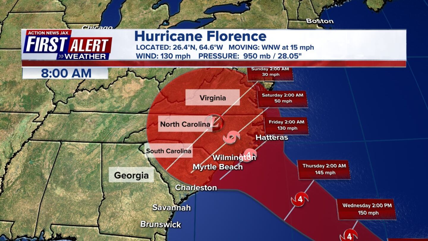
On Tuesday morning, hurricane watches were issued along the coast from Charleston to the Outer Banks. Landfall looks to be late Thursday afternoon, between Morehead City, N.C., and Wilmington, N.C.
CHARLOTTE: Action News Jax sister station WSOC-TV has live updates
The highest impact areas will be from Myrtle Beach northward to the Outer Banks, with dangerous currents and surf. The Charlotte area will see tropical storm-force winds, bands of very heavy rain, and heavy flooding threats -- especially for our eastern counties.
Tropical storm-force winds can be felt in Charlotte as early as Wednesday night, and depending on the path, we could feel winds in excess of 75 mph. The earliest reasonable time that tropical-storm-force winds could arrive in the United States from late Wednesday, and the most likely time is Thursday morning, the National Hurricane Center said.
Wednesday should be the last full day to prepare, so plan accordingly.
11 A.M. UPDATE: Florence is still a Category 4 hurricane but is forecasted to weaken to a Category 3 by landfall on Friday morning. Forward speed is expected to drop once it moves over land -- enhancing a serious flooding threat for the Carolinas.
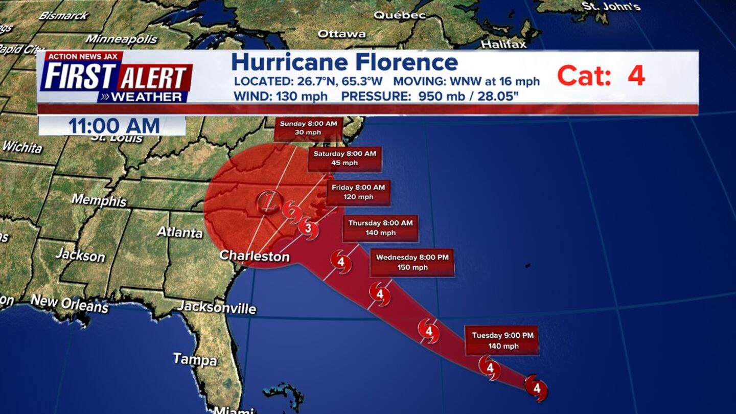
The hurricane still has a maximum sustained winds of 130 mph.
A Storm Surge Watch is in effect currently for Edisto Beach, South Carolina to the North Carolina-Virginia border, Albemarle and Pamlico Sounds, including the Neuse and Pamlico Rivers.
A Hurricane Watch is in effect for Edisto Beach South Carolina to the North Carolina-Virginia border and Albemarle and Pamlico Sounds.
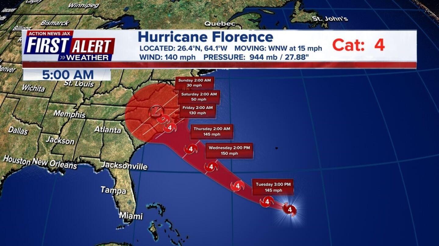
8 A.M. UPDATE: Hurricane Florence has weakened slightly but is expected to restrengthen later today. The Category 4 hurricane's maximum sustained winds have decreased to 130 mph.
The National Hurricane Center says a new report from an Air Force Reserve Unit hurricane hunter aircraft indicates that Hurricane Florence's top sustained winds have decreased slightly to 130 mph, with higher gusts.
Florence is still a Category 4 hurricane and is expected to regain its top wind strength in the next day or so. It remains an extremely dangerous major hurricane through Thursday night.
8 AM update: #Florence a bit weaker with winds down to 130 mph. Movement WNW at 15 mph. Eyewall replacement still occuring - strengthening expected later today #FirstAlertWX pic.twitter.com/fxCaXCDW85
— Corey Simma (@CSimmaWX) September 11, 2018
5 A.M. UPDATE: According to the 5 a.m. update, Hurricane Florence is still a Category 4. It has sustained winds at 140 mph. Florence is moving WNW at 15 mph and is currently about 660 miles south of Bermuda.
Hurricane Watches have been issued all along the coast of North and South Carolina.
Cox Media Group


