:quality(70)/cloudfront-us-east-1.images.arcpublishing.com/cmg/WW5AJL3ARQUGDQMAQUNSFX4CLE.jpg)
Jacksonville, Fl. — The “Buresh Bottom Line”: Always be prepared!.....First Alert Hurricane Survival Guide... City of Jacksonville Preparedness Guide... Georgia Hurricane Guide.
STAY INFORMED: Get the * FREE * First Alert Weather app
FREE NEWS UPDATES, ALERTS: Action News Jax app for Apple | For Android
WATCH “Talking & Tracking the Tropics: The Science Behind the Season”
WATCH “Preparing for the Storm”
READ the First Alert Hurricane Center “Survival Guide”
***** ALWAYS CHECK & RE-CHECK THE LATEST FORECAST & UPDATES! *****
The last advisory on “Isaias” was issued early Wed., Aug. 5th after becoming absorbed by a large nontropical system over SE Canada.
Low pressure/tropical wave ’92-L’/‘Potential Cyclone Nine’ was upgraded to tropical storm Isaias Wed. evening while over the Eastern Caribbean.... moved over Eastern Dominican Republic Thu. afternoon then offshore & quickly reorganized becoming the 2nd hurricane of the Atlantic season a little before midnight. Isaias quite literally fell apart Sat. afternoon while crossing Andros Island of the Bahamas & the mid & low level centers have pretty much been disjointed ever since. But at the last minute, Isaias strengthened into a hurricane Mon. evening, Aug. 3rd before coming ashore about 11:15pm EDT near Ocean Isle Beach, NC with max sustained winds near 85 mph & min central pressure of 988mb/29.18″. It’s the fifth season in a row with 2 or more U.S. landfalls & the earliest on record to have 5 named storms hit the U.S. breaking the record of 5 Aug. 18, 1916. Isaias was the 5th July named storm over the Atlantic which ties the record for the month set in 2005. And it marks the fastest to ‘I’ beating the previous record set by “Irene” in - when else - 2005.
Isaias raced north/slightly northeast after making landfall Mon. evening, Aug. 3rd on the SW coast of N. Carolina then moved across New York & Western New England. Flooding rain & a few tornadoes along with strong & gusty winds accompanied the system all the way north into Canada.


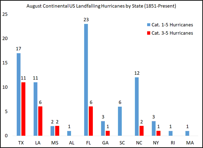
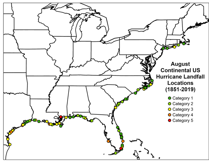
The graph & map below - the next 2 images - courtesy Dr. Phil Klotzbach showing Aug. landfalling hurricanes:
Meanwhile... a tropical wave has limited potential to develop some over the Central Atlantic while holding nearly stationary or drifting some to the west. Significant development does not appear likely.
One area to keep an eye on in the long run might be the NW Caribbean &/or Southern/SW Gulf of Mexico. Tropical waves are marching west at fairly low level latitudes driven by the strong Bermuda high, & we might see “late bloomer” by mid month.


And t.d. #10 formed just off the coast of Africa Fri. over the far E. Atlantic but has dissipated.


:quality(70)/cloudfront-us-east-1.images.arcpublishing.com/cmg/OP4L4IUHEIWRTTX257DKOM4IMU.jpg)
:quality(70)/cloudfront-us-east-1.images.arcpublishing.com/cmg/GUKNEPXKO4TU3TGUXRFOFQBQLY.jpg)
:quality(70)/cloudfront-us-east-1.images.arcpublishing.com/cmg/SATRLH535RE6HIJIPS5ZLZB4XI.jpg)
:quality(70)/cloudfront-us-east-1.images.arcpublishing.com/cmg/M7DQOP5FJNTRMVP5QYWYEBACAI.jpg)
:quality(70)/cloudfront-us-east-1.images.arcpublishing.com/cmg/YFVQFPSEYFGUJNN5FIL45PWXNM.jpg)