:quality(70)/cloudfront-us-east-1.images.arcpublishing.com/cmg/WW5AJL3ARQUGDQMAQUNSFX4CLE.jpg)
Jacksonville, Fl. — The “Buresh Bottom Line”: Always be prepared!.....First Alert Hurricane Survival Guide... City of Jacksonville Preparedness Guide... Georgia Hurricane Guide.
STAY INFORMED: Get the * FREE * First Alert Weather app
FREE NEWS UPDATES, ALERTS: Action News Jax app for Apple | For Android
WATCH “Talking & Tracking the Tropics: The Science Behind the Season”
WATCH “Preparing for the Storm”
READ the First Alert Hurricane Center “Survival Guide”
***** ALWAYS CHECK & RE-CHECK THE LATEST FORECAST & UPDATES! *****
LOCAL - JAX/NE FL./SE GA. impacts from current tropical activity: ** None directly ** ... but folks traveling or who live anywhere along the Gulf Coast from Florida’s Western Panhandle to Texas - need to stay up to date on future forecasts regarding the tropics as fast changes/development will be possible this week.
**NO ** local impacts from Laura for Jacksonville/NE Fl./SE Ga. as Marco dissipates & Laura strengthens. Technically - we will have 2 named storms over the Gulf at the same time but not for long.
LAURA:
Laura will be the big story coming out of the Gulf as the storm will have plenty of warm water to cross under favorable (atmospheric) conditions to strengthen through midweek before reaching the Western Gulf Coast Wed. night-Thu. Models have been pretty stable with a landfall pretty close to where Rita came ashore in 2005, but the expanding Bermuda High still keeps Texas as a spot for a potential landfall. This is a very close call for Houston & Galveston. A track over or near oil wells & the petroleum facilities could mean a “bump at the pump” over the next week or two.
There will be plenty of significant impacts for Louisiana too & - at least to some degree - for coastal Mississippi & Alabama as well.
Strong tropical wave ’98-L’ was upgraded to tropical depression #13 Wed. then to tropical storm “Laura” Fri. while steadily moving west & across or near Puerto Rico, Hispaniola & Cuba. This is the fastest to the 12th storm breaking the record of “Luis” on Aug. 29, 1995. As the Bermuda High to the north expands & strengthens, Laura should continue a steady track west before a slow bend to the northwest & forecast models are in excellent agreement on such. This takes Laura away from Cuba followed by a 2-day track across the Gulf of Mexico. There remains a reasonable chance - as has been the case for days now - for a track farther west as the Bermuda High flexes its muscles (helping to protect Jacksonville/NE Fl./SE Ga). Despite land interaction & moderate shear out of the north, satellite & radar data still show a relatively well organized cyclone with upper level outflow evident over the top of the storm. Given the strengthening already underway Mon. night & the presence of good upper level outflow combined with less shear, Laura may fairly quickly strengthen once over the Gulf of Mexico Tue.-Wed. with a period of rapid intensification possible. As has been the case since its inception last week, I’ve been concerned about a “late bloomer” on this one.
As Marco dissipates near the Gulf Coast, it looks like the alleyway to the Gulf opened up by a departing/weakening upper level trough will pretty quickly close as an extension of the sprawling Atlantic Bermuda High builds to the west. This turn of events is likely why forecast models have trended west in what could be a major hurricane threatening Texas &/or Louisiana mid to late week. The models are locked in on timing for the most part - later Wed. into early Thu. for a landfall... & pretty much all of the models show some form of strengthening. The GFS is not as intense & a little more east.... the UKMET is off the charts with a major hurricane (& a little more west which would up the ante for Texas)... & the European is in-between.
MARCO:
Tropical wave ’97-L’ has turned rather sharply to the north after entering the Caribbean Mon. night & has been upgraded - as of Thu. morning - to tropical depression #14 & then to tropical storm “Marco” Fri. evening & briefly to a hurricane Sunday afternoon before being downgraded again to a tropical storm then - late Mon. evening - to a tropical depression. Landfall was on the SE tip of Louisiana at the mouth of the Mississippi Mon. evening about 7pm EDT. Marco - always a compact tropical cyclone - has been slowing some & turning more north & now west becoming steered by the low level flow as the system falls apart. Marco missed most of the potential land interaction with the Yucatan Peninsula which allowed for short term strengthening but shear out of the SW is strong (25+ mph) & continue to pound & consequently weaken Marco. The cyclone was effectively “decapitated” Sun. night as the low level center churned southeast of New Orleans while a mid level center was to the northeast with all the heavy rain & gusty winds. Virtually all of the heavy rain & wind remains in the north & east quadrant due to the persistent shear with flooding & isolated waterspouts/tornadoes being the primary threats from the Fl. Panhandle to near & especially east of New Orleans but becoming more scattered through Tue.
There has been quite a bit of scuttlebutt regarding a possible “Fujiwhara effect” between Marco & Laura. I still see the two systems remaining their own separate entities, so I’m not going there. It continues to look more likely that Marco will not still be a “thing” as Laura starts to dominate the Gulf (tropical cyclone Fujiwhara effects have happened in the past, by the way). In any case... no need for a lot of hype(!) or concern on this possibility as is obvious now(!).
Overall conditions across the Atlantic Basin appear “ready to go” as we head into late Aug. & early Sept. (see velocity potential anomalies map below). I’m also tracking a potential long track tropical disturbance soon to move westward across the Atlantic that could threaten some part of the U.S. between ~Sept. 1 & Sept. 9th.


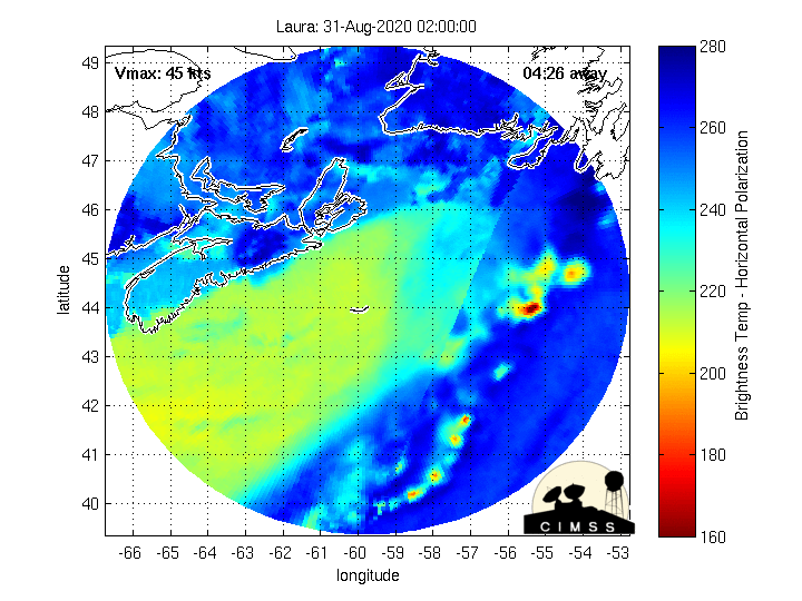
CIMMS Integrated Microwave Imagery:


Lots of spaghetti(!):


Lots of rain along & near the Gulf Coast this week due to a combination of tropical activity & an upper level trough with extreme rainfall possible from the upper Texas coast to the Central Fl. Panhandle:
A change of phase of the MJO (Madden-Julian oscillation) should help lead to an uptick in Atlantic tropical cyclones late this month into September. The upper level “velocity potential anomalies” map below shows “upward motion” - green lines - spreading east from the already active E. Pacific. Such a pattern often correlates to an increase in tropical systems that would eventually include the Atlantic Basin.


A strong tropical wave over the far Eastern Atlantic is marching west....


:quality(70)/cloudfront-us-east-1.images.arcpublishing.com/cmg/2A2742EUVFCDRJBTDWWG5EQ36E.jpeg)
:quality(70)/cloudfront-us-east-1.images.arcpublishing.com/cmg/YNYHQR4LBVFI3OJGCFF32OEDVM.png)
:quality(70)/d1hfln2sfez66z.cloudfront.net/04-29-2024/t_fe679c4495024c2399a845060113ad20_name_file_960x540_1200_v3_1_.jpg)
:quality(70)/cloudfront-us-east-1.images.arcpublishing.com/cmg/OOUFYBT7MBHC5C2CK7SMG6D35I.jpg)
:quality(70)/cloudfront-us-east-1.images.arcpublishing.com/cmg/F2HDNUPNINBJVMOJF6EVE2VRMI.png)