:quality(70)/cloudfront-us-east-1.images.arcpublishing.com/cmg/WW5AJL3ARQUGDQMAQUNSFX4CLE.jpg)
Jacksonville, Fl. — The “Buresh Bottom Line”: Always be prepared!.....First Alert Hurricane Survival Guide... City of Jacksonville Preparedness Guide... Georgia Hurricane Guide.
STAY INFORMED: Get the * FREE * First Alert Weather app
FREE NEWS UPDATES, ALERTS: Action News Jax app for Apple | For Android
WATCH “Talking & Tracking the Tropics: The Science Behind the Season”
WATCH “Preparing for the Storm”
READ the First Alert Hurricane Center “Survival Guide”
***** ALWAYS CHECK & RE-CHECK THE LATEST FORECAST & UPDATES! *****
LOCAL - JAX/NE FL./SE GA. impacts from Laura: ** None ** ... but one of the strongest landfalling hurricanes in Louisiana’s history &, in fact, for any of the Gulf Coast. The swift northward movement of Laura will translate into a threat well inland with wind, tornadoes & very heavy rain/flash flooding. Travel along I-10 from Central Louisiana to at least the Texas border will be nearly impossible & - at the very least - extremely dangerous through midday Thu.
LAURA ** A catastrophic landfall for the Central & SW Louisiana Coast **:
The 4th Atlantic hurricane of the 2020 season - only 7 other seasons have had as many hurricanes by Aug. 25th - 1886, 1893, 1916, 1966, 1995,1996 & 2005 - Laura is - as expected - the big story coming out of the Gulf as the storm crossed warm water under favorable (atmospheric) conditions to allow for steady & then rapid strengthening through Wednesday evening before reaching the Western Gulf Coast in the wee hours of the morning Thu. Landfall was east of the Sabine River about 30 miles south of Lake Charles at Cameron, LA about 1:50am EDT sparing the major metropolitan areas of Houston & New Orleans. A track over or near oil wells & the petroleum facilities could mean a “bump at the pump” over the next week or two.
This is the first “major” (Cat. 3+) hurricane over the Gulf since Michael in Oct., 2018 (Fl. Panhandle) & the first in *August* since Harvey in 2017 (Texas coast & almost 3 years to the day). Laura will be the 7th named storm to hit U.S. soil this season so far - a record for the number of hits before the end of Aug. (1886 & 1916 had 6 U.S. landfalls)
There will be plenty of severe impacts for the far upper Texas coast & especially Louisiana & - at least to some degree - for coastal Mississippi & Alabama as well. The relatively fast movement will mean Laura will likely maintain tropical characteristics & some intensity well inland with with a wind, tornado & flooding threat north into Arkansas then bending east across parts of Tennessee & Kentucky.
Strong tropical wave ’98-L’ was upgraded to tropical depression #13 Wed. then to tropical storm “Laura” Fri. while steadily moving west & across or near Puerto Rico, Hispaniola & Cuba... reaching hurricane strength Tue. morning over the Southern Gulf of Mexico the a “major” Cat. 3 hurricane Wed. morning & a Cat. 4 Wed. afternoon - an increase in winds of 75 mph in less than 24 hours & appears to be the fastest intensifying in the Gulf on record! This is also the fastest to the 12th storm breaking the record of “Luis” on Aug. 29, 1995. With the strong Bermuda High to the east, Laura will turn more northward through Thu. My concerns about a “late bloomer” on this one - unfortunately - come to fruition. There was an increase in shear &, of course, friction upon approach to land but the size, organization (steady state), intensity & speed of Laura offset most of the negative effects keeping Laura severe/”steady state” - a high end Cat. 4 - upon the hit on the SW Louisiana coast.
Of increasing interest (& concern) is what happens once Laura is inland. The tropical cyclone will move quite quickly N/NE before bending rather sharply to the right. The GFS model is faster to merge the storm with an upper level trough & secondary mid-latitude surface low near & to the south of the Great Lakes. The European & UKMET models, on the other hand, keep Laura as its own rather strong entity while rolling east across Kentucky & Tennessee then offshore of N. Carolina/Chesapeake Bay by late in the weekend. Such a track would imply severe weather - wind/rain/tornadoes - all along the track from Arkansas to the east coast with possible redevelopment of a tropical cyclone once offshore of the Mid Atlantic states over the Western Atlantic while moving away from the U.S. over the NW Atlantic. This possibility is too significant to ignore given the potential for property damage all the way from Arkansas & Missouri through parts of the Ohio & Tennessee Valley’s to the coasts of Virginia & N. Carolina. The jet stream is rather strong for this time of year across the mid & northern latitudes of the U.S. so if Laura gets caught up by the steering of the jet stream & its dynamics (can draw some of the upper level strong winds down to the surface)... combined with swift forward momentum (speeding east), it would all add up to a serious & unique weather situation for many states & populated areas far from the initial intense landfall. There is a precedent for such - Ike in September, 2008 came ashore in Texas & brought damaging winds as far away as Cincinnati, Ohio.
On a sidenote: overall conditions across the Atlantic Basin appear to continue to be “ready to go” as we move into early Sept. (see velocity potential anomalies map below). I’m also tracking at least one potential long track tropical disturbance soon to move westward across the Atlantic that could be near some part of the U.S. between ~Sept. 3 & Sept. 9th as well as a wave/disturbance that could be over the SW Atlantic as early as next week.

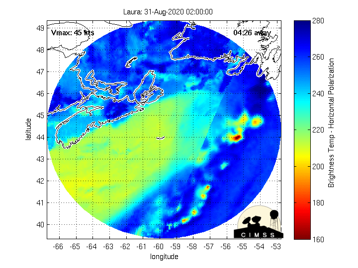
Fascinating microwave imagery courtesy CIMMS (Cooperative Institute for Meteorological Satellite Studies) shows the rapid intensification of Laura:


Keep in mind that storm surge forecasts do *not* include wave action. It’s anticipated that storm surge near & to the immediate east of the eye could extend as far as 30 miles inland!


Spaghetti plots:


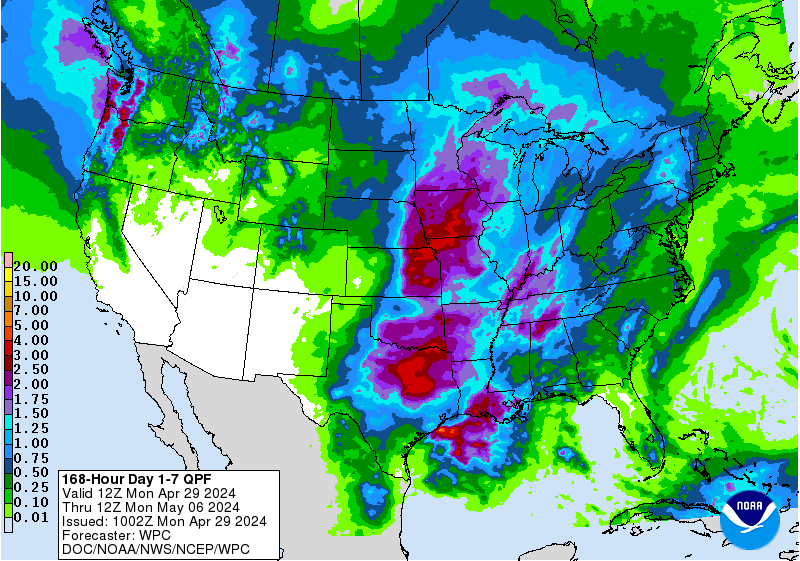
Rainfall forecast.... with very heavy rain extending well inland due to the swift movement of Laura not to mention a tornado threat:
August hurricane landfalls since 1851 courtesy Dr. Phil Klotzbach:

A change of phase of the MJO (Madden-Julian oscillation) should help lead to an uptick in Atlantic tropical cyclones late this month into September. The upper level “velocity potential anomalies” map below shows “upward motion” - green lines - spreading east from the already active E. Pacific. Such a pattern often correlates to an increase in tropical systems that would eventually include the Atlantic Basin.


A strong tropical wave over the far Eastern Atlantic is marching west....


:quality(70)/d1hfln2sfez66z.cloudfront.net/04-24-2024/t_d73855398dca4bf5a6e1eca4fedb0fdd_name_file_960x540_1200_v3_1_.jpg)
:quality(70)/d1hfln2sfez66z.cloudfront.net/04-25-2024/t_24132b8d08134f65ab5ac0a3ac2f17e7_name_file_960x540_1200_v3_1_.jpg)
:quality(70)/cloudfront-us-east-1.images.arcpublishing.com/cmg/NGMKLAKH5NF27JQOAGV7JN25OU.jpg)
:quality(70)/cloudfront-us-east-1.images.arcpublishing.com/cmg/I4KFDXPDYFEBDEPUHDMGX3IWK4.jpg)
:quality(70)/d1hfln2sfez66z.cloudfront.net/04-23-2024/t_8846f6a1613746e2863363cea1df0c34_name_file_960x540_1200_v3_1_.jpg)