
Jacksonville, Fl. — The “Buresh Bottom Line”: Always be prepared!.....First Alert Hurricane Survival Guide... City of Jacksonville Preparedness Guide... Georgia Hurricane Guide.
STAY INFORMED: Get the * FREE * First Alert Weather app
FREE NEWS UPDATES, ALERTS: Action News Jax app for Apple | For Android
WATCH “Talking & Tracking the Tropics: The Science Behind the Season”
WATCH “Preparing for the Storm”
READ the First Alert Hurricane Center “Survival Guide”
***** ALWAYS CHECK & RE-CHECK THE LATEST FORECAST & UPDATES! *****
The Caribbean/Gulf of Mexico & SW Atlantic will remain the areas to keep an eye on into November (climatologically favored too).
*** NO impacts from Zeta on Jacksonville/NE Fl./SE Ga. Areas along the Gulf Coast between from the Texas/Louisiana border to the Fl. Panhandle should stay up to date on the latest forecasts as Zeta moves over the Gulf of Mexico through midweek.....
Tracking:
(1) EPSILON: The last NHC advisory was issued Sun. evening. low pressure over the Central Atlantic evolved from an upper low, became t.d. #27 Mon. morning & then to tropical storm Epsilon within a few hours - the fastest to the 27th storm breaking the record set in - of course - 2005.... & became a hurricane Tue. strengthening into a Cat. 3 Wed. before leveling off again as a Cat. 2 & then steady state as a Cat. 1. The core of the hurricane moved to the east of Bermuda Thu. Epsilon transitioned to post-tropical Sunday evening & is now a large ocean storm over the N. Atlantic.

(2) ZETA: Low pressure over the NW Caribbean near & south of the Cayman Islands was upgraded to tropical depression #28 Sat. afternoon then to tropical storm Zeta early Sunday - the fastest to the 27th tropical cyclone easily breaking the record of Nov. 29, 2005 & one away from tying the all-time Atlantic record for the most storms in a season. Forecast models seem to have finally(!) caught on to Zeta & its track. The center “jumped around” much of Sunday as convection fired & the system organized. But a core has become established & Zeta has started its west/northwest move as an upper level ridge builds across/near Fl./the Eastern Gulf - the Fl. peninsula “protector” this season. Zeta should be steered more northwest then north through midweek. It’s worth noting that most models this season have initially been too far east with the ultimate outcome (track).
It is clear that overall conditions - sea surface temps., deep oceanic heat content & low shear - are just about ideal through Monday, & it’s possible there could be fairly fast if not rapid intensification for a time. Conditions are, however, quite the opposite across the Northern Gulf of Mexico which should cause weakening upon approach to a late Wed. landfall along the Gulf Coast.
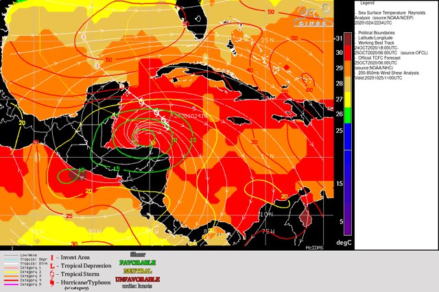
Water vapor imagery below shows a vast area of dry mid & upper level air over virtually all of the Gulf of Mexico. There should be some moistening in the days ahead but Zeta will still have to battle this dry air once the storm enters the Gulf (late Mon. night/Tue.).

Models:
The European has been the farthest west & slowest (true all season) - but is now much faster & trending east with a landfall Wed. night west of New Orleans... the GFS model remains faster & the farthest east - a little east of New Orleans Wed. afternoon... the UKMET is New Orleans or slightly west by late Wed. Overall, there is much better agreement among the models.
As for intensity... increasing shear & drier air + a little lower sea surface temps. (but still 80F +) should result in Zeta hitting the Gulf Coast off its peak. Of note, however, upper level “ventilation” increases thanks to an approaching strong upper level trough that will help steer Zeta more north then northeast while accelerating by midweek. I would not be surprised if the system “goes hurricane” rather quickly then levels off &/or weakens while moving north/northeast over the Central/Northern Gulf. It looks like there will be some land interaction with the Yucatan Peninsula Mon. night - for about 5-8 hours that would cause at least some disruption in intensity followed by perhaps some restrengthening over the Southern Gulf before encountering the less favorable conditions over the Central & especially Northern Gulf.
Summary:
In any case, it’s a scenario we’ve scene multiple times this hurricane season: a landfalling tropical cyclone (as a high end tropical storm or Cat. 1 hurricane) anywhere between the upper Texas coast & the Fl. Panhandle midweek centered a little either way of New Orleans late Wed./Wed. night. The first landfall will be near Cancun late Mon./Mon. night over the NE Yucatan Peninsula as a hurricane. There will be no impacts on Jacksonville/NE Fl./SE Ga.


“Extra spaghetti":


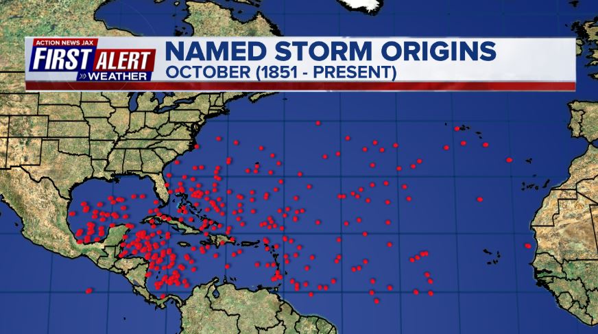
October tropical cyclone origin points are clustered over the Caribbean, Gulf of Mexico & SW Atlantic:
Atlantic Basin wave forecast for 24, 48 & 72 hours respectively:


