
Jacksonville, Fl. — The “Buresh Bottom Line”: Always be prepared!.....First Alert Hurricane Preparation Guide... City of Jacksonville Preparedness Guide... Georgia Hurricane Guide.
STAY INFORMED: Get the * FREE * First Alert Weather app
FREE NEWS UPDATES, ALERTS: Action News Jax app for Apple | For Android
WATCH “Preparing for the Storm”
WATCH “The Ins & Outs of Hurricane Season”
READ the First Alert Hurricane Center “Survival Guide”
LISTEN & WATCH “Surviving the Storm” - WOKV Radio & Action News Jax
***** ALWAYS CHECK & RE-CHECK THE LATEST FORECAST & UPDATES! *****
REMEMBER WHEN A TROPICAL STORM OR HURRICANE IS APPROACHING: Taping windows is *NOT* helpful & will not keep glass from breaking.
Realize the forecast cone (”cone of uncertainty”) is the average forecast error over a given time - out to 5 days - & *does not* indicate the width of the storm &/or damage that might occur.

I continue to track an unseasonably strong & organized tropical wave over the far Eastern Atlantic that emerged off the coast of Africa early Fri. Often times in June, such waves don’t have much of a chance to develop let alone make it across the Atlantic given typical early season wind shear & ocean temps. that are usually far off their peak. *But* this wave may be very different....
The set-up makes sense given: (1) an early season uptick in tropical waves that have already been marching westward... (2) above avg. & warm ocean temps. over most of the lower Atlantic Basin (has cooled to the north)... & (3) the El Nino has just kicked in & is still strengthening (which may help to slow the season near its climatological peak in Sept./early Oct.).
It looks like this wave will develop fairly quickly while moving west & may become a tropical cyclone (tropical storm ‘Bret’) within the next few days. From there it appears conditions are favorable for intensification into a hurricane. Through the middle of next week, the system will remain far from any land areas but at least will be approaching the E/NE Caribbean by about Thu./Fri. From there the wave should turn more northwest, possibly more northward moving into or near the SW Atlantic next weekend or shortly thereafter or in about 7-10 days in other words. It’s still too early to determine the movement much beyond late next week/ next weekend. At the moment - & into a good part of next week - at least some troughing will remain over or near the Eastern U.S. The location of this trough could prove critical on the ultimate path in the long range.
So this is a “stay tuned” situation for right now with lots of time to track the wave & its likely subsequent development.
The rest of the Atlantic Basin is quiet now. Weak troughing over/near the Gulf of Mexico will need to continue to be monitored for possible persistent t’storm clusters that may try to develop low pressure. The GFS model has been trying to develop a system moving northward from the Caribbean which may be related to (a) the upper trough or (b) persistent convection couched over the SW Caribbean. But not much to hang one’s hat on for the moment with little support from other global models.


Water vapor loop (dark blue/yellow is dry mid & upper level air):


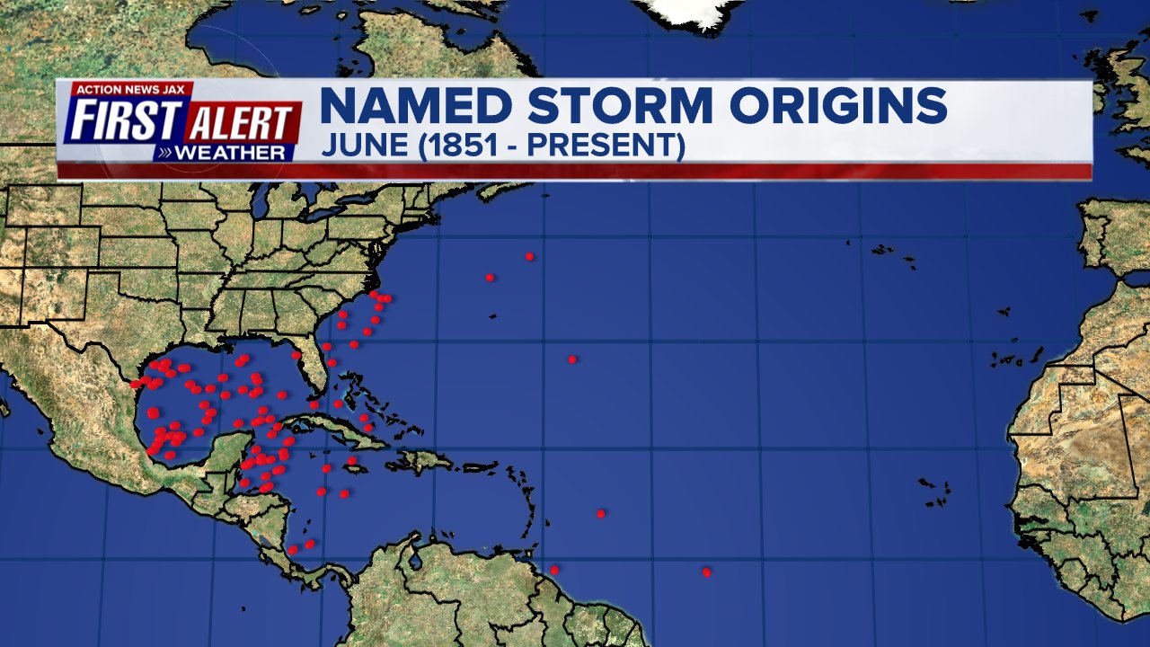
June tropical cyclone origins:
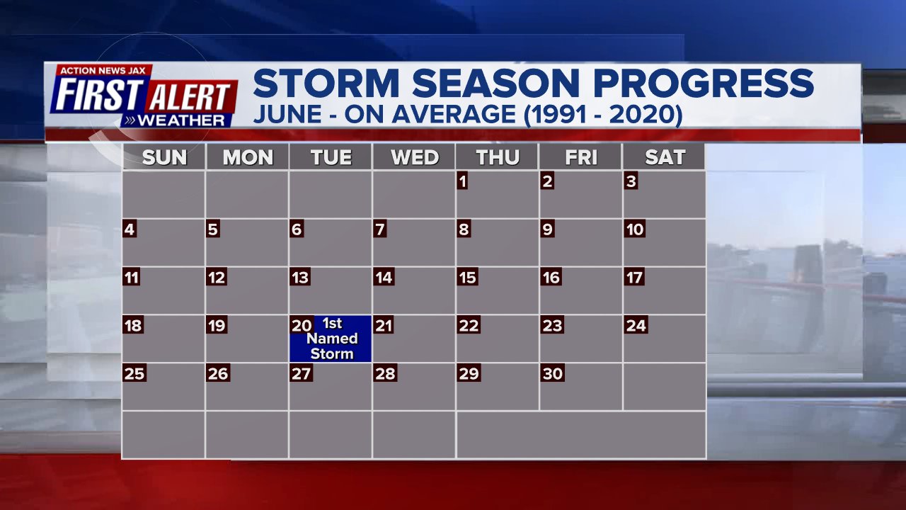
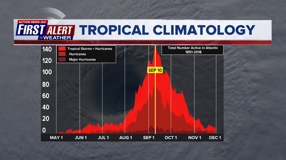
Averages below based on climatology for the Atlantic Basin for June:
Wind shear:


Saharan dust spreads west each year from Africa by the prevailing winds (from east to west over the Atlantic). Dry air - yellow/orange/red/pink. Widespread dust is indicative of dry air that can impede the development of tropical cyclones. However, sometimes “wanna’ be” waves will just wait until they get to the other side of - or away from - the plume then try to develop if other conditions are favorable. In my personal opinion, way too much is made about the presence of Saharan dust & how it relates to tropical cyclones. In any case, the peak of Saharan dust typically is in June & July.

2023 names..... “Bret” is the next name on the Atlantic list (names are picked at random by the World Meteorological Organization... repeat every 6 years). Historic storms are retired [Florence & Michael in ’18... Dorian in ’19 & Laura, Eta & Iota in ‘20, Ida in ‘21 & Fiona & Ian in ‘22]). In fact, this year’s list of names is rather infamous with “Katrina”, “Rita” & “Wilma” retired from the ‘05 list & “Harvey”, “Irma”,“Maria” & “Nate” from the ‘17 list. The WMO decided - beginning in 2021 - that the Greek alphabet will be no longer used & instead there will be a supplemental list of names if the first list is exhausted (has only happened three times - 2005, 2020 & 2021). The naming of tropical cyclones began on a consistent basis in 1953. More on the history of naming tropical cyclones * here *.


East Atlantic:


Mid & upper level wind shear (enemy of tropical cyclones) analysis (CIMMS). The red lines indicate strong shear:

Water vapor imagery (dark blue indicates dry air):

Deep oceanic heat content over the Gulf, Caribbean & deep tropical Atlantic. The brighter colors will expand rather dramatically by Aug./Sept./Oct.:

Sea surface temp. anomalies:


SE U.S. surface map:

Surface analysis centered on the tropical Atlantic:

Surface analysis of the Gulf:

Caribbean:

GFS wave forecast at 48 & 72 hours (2 & 3 days):


Atlantic Basin wave period forecast for 24, 48 & 72 hours respectively:


The East Pacific (may see development by the weekend south of Mexico):


West Pacific:

Global tropical activity:


“Biparjoy” has come ashore near the Pakistan/India border & is weakening while moving inland:


Cox Media Group


