:quality(70)/cloudfront-us-east-1.images.arcpublishing.com/cmg/WW5AJL3ARQUGDQMAQUNSFX4CLE.jpg)
Jacksonville, Fl. — The “Buresh Bottom Line”: Always be prepared!.....First Alert Hurricane Survival Guide... City of Jacksonville Preparedness Guide... Georgia Hurricane Guide.
STAY INFORMED: Get the * FREE * First Alert Weather app
FREE NEWS UPDATES, ALERTS: Action News Jax app for Apple | For Android
WATCH “Talking & Tracking the Tropics: The Science Behind the Season”
WATCH “Preparing for the Storm”
READ the First Alert Hurricane Center “Survival Guide”
***** ALWAYS CHECK & RE-CHECK THE LATEST FORECAST & UPDATES! *****
*** T.D. 19 WILL NOT HAVE DIRECT IMPACTS ON JACKSONVILLE/NE FL./SE GA. ***
TROPICS:
(1) an area of ‘disturbed’ weather (showers & storms) that developed over the Bahamas during the last couple days was upgraded to tropical depression #19 Fri. afternoon. It’s possible that t.d. #19 will become a tropical storm upon approach to SE Florida but the most likely scenario is tropical storm strength once back over water - the warm water of the Eastern Gulf. There will be heavy rain & some gusty winds for South & parts of Central Florida. Of greater concern is the potential for intensification once over the Gulf of Mexico & then a possible landfall on the Gulf Coast. Models have been having a difficult time “finding” the depression but recent model runs seem to doing better. Right now the forecast is for west/northwest movement to the Northern Gulf by Mon./Tue. possibly as a hurricane. Lots of uncertainty right now on the track & intensity but there should be better resolution through the day Saturday as models start to play catch-up. Special 4-times-a-day weather balloon launches are scheduled across the Gulf & Southeast U.S. over the weekend into next week with the hope that the extra realtime data analysis will result in better/more accurate model forecasts. In any case, everyone along the Gulf Coast needs to stay up to date on the latest forecasts.


(2) Tropical depression #17 formed over the Eastern Atlantic Sunday & was upgraded to tropical storm “Paulette” Mon. The fastest ever to ’P’ easily beating the old record of Philippe Sept. 17, 2005. The large system will move steadily - but rather slowly - to the west/northwest over the open Atlantic this week into the weekend. Paulette has struggled against strong shear & some dry air but the environment improves rather dramatically over the weekend into next week at which time Paulette should strengthen. In anticipation of a deepening tropical cyclone, the forecast is for Paulette to turn more northward then northeast in the long range. So as menacing for the U.S. east coast as the track might look through the weekend (if one were to extrapolate from its W/NW heading the next few days), Paulette continues to look like an “ocean storm” staying well east of the U.S. but will be in the vicinity of Bermuda Tue.-Wed. Easterly swells will reach the coast over the weekend into next week as Paulette intensifies increasing the rip current risk from Florida up the east coast to New England.
(3) Tropical depression #18 was upgraded just off the coast of Africa early Mon. then to tropical storm “Rene” Mon. afternoon before a weakening trend Tue. night followed by another strengthening trend Thu. Rene will turn more northward this weekend/early next week over the Eastern then Central Atlantic & should go through a strengthening phase for a time. There may eventually be some interaction with tropical storm Paulette, but it seems clear that Rene will stay far to the east over the open Atlantic. Rene is forecast to turn more west again in the long run as the storm weakens & becomes more shallow.


(4) Another in a series of active tropical waves is rolling off Africa. This one looks to move west at a lower latitude riding a narrow ridge on the underside of the the two tropical cyclones (Paulette/Rene) to the north. This wave may be something to keep a close eye on next week as it could be nearing parts of the Caribbean mid to late week.... while strengthening. Long range models have been variable but are generally indicating - at this point - an alley way through the Western Atlantic that may allow for an “escape” (vs. something farther west that could impact land). But still early.
Yet another tropical wave with the potential for development will fairly quickly follow.
(5) A lowering of pressures has been indicated by forecast models over the Western Gulf of Mexico over the weekend into early next week. Low pressure may eventually develop... or there could be some interaction with other waves/disturbances. If so, it’s an area to keep an eye on for possible tropical development.


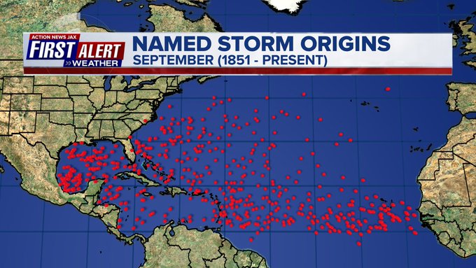
September is usually the most active month of the hurricane season:


:quality(70)/cloudfront-us-east-1.images.arcpublishing.com/cmg/MNQUC6FHZVHBBIX54VK7ZYMRIQ.jpg)
:quality(70)/cloudfront-us-east-1.images.arcpublishing.com/cmg/AQ734LEZ45AENE53JO7NVSH5HA.jpg)
:quality(70)/cloudfront-us-east-1.images.arcpublishing.com/cmg/SPL6W4EORNAJDGIBFCNGGKDLLU.png)
:quality(70)/d1hfln2sfez66z.cloudfront.net/04-29-2024/t_fb63cd75fea74cbc85371a1f93ea88fc_name_file_960x540_1200_v3_1_.jpg)
:quality(70)/cloudfront-us-east-1.images.arcpublishing.com/cmg/VAM4IBO2KVGI7GDIPZEILKRCM4.jpg)