Tropical Storm Fred made landfall in the Florida Panhandle on Monday afternoon.
Chief Meteorologist Mike Buresh said heavy rain and strong winds are expected for the Panhandle, with a storm surge as high as 5 feet.
Northeast Florida and Southeast Georgia can expect a few distant occasional heavy rain bands with embedded thunderstorms, producing periods of very heavy rain and wind gusts up to 45 mph moving quickly north/northwest.
Fred will continue inland through Tuesday while weakening, but still producing heavy rain and flooding through parts of Georgia, Alabama, Tennessee and the Carolinas.
Tropical moisture trailing behind will help trigger a few more bands of heavy rain and storms Tuesday locally. Total rainfall will average 1-2,” a few spots more than 3″.
See live updates from our coverage of Tropical Storm Fred below:
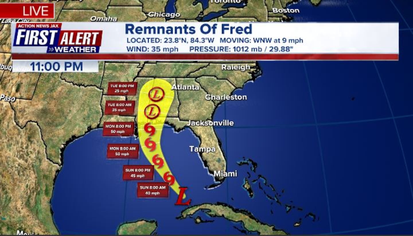
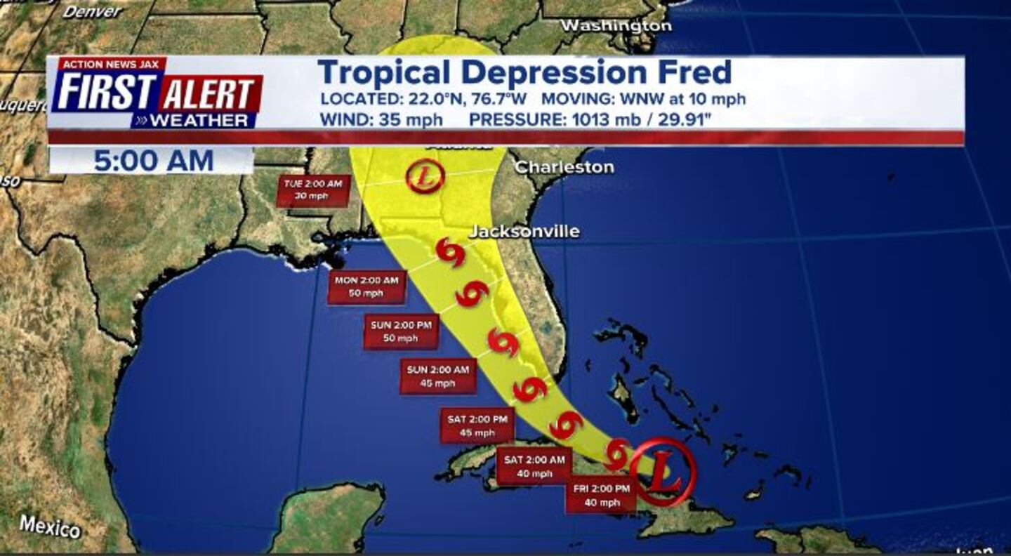
UPDATE 8/17 5 a.m.
#Fred is now a tropical depression. #FirstAlertWX pic.twitter.com/Mmj6zpREyz
— Garrett Bedenbaugh (@wxgarrett) August 17, 2021
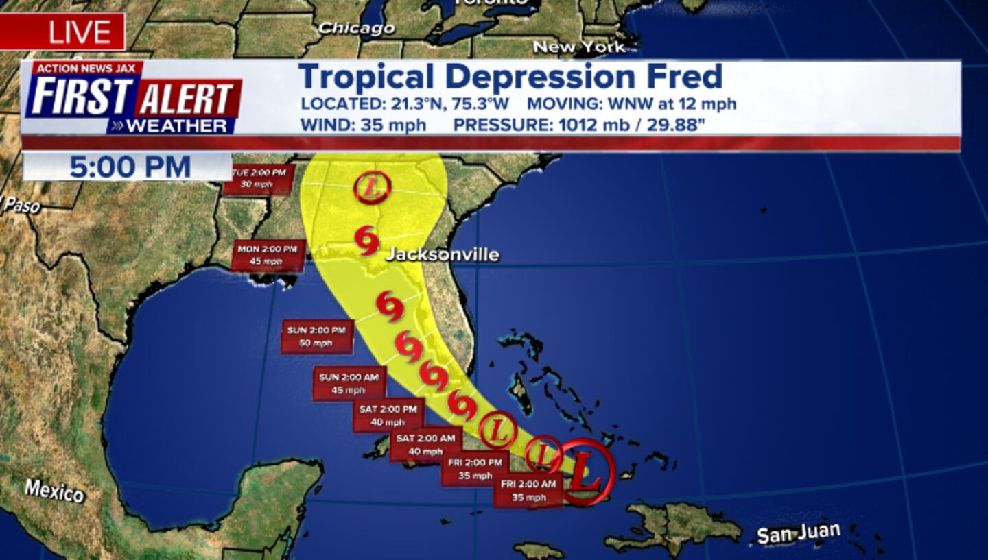
UPDATE 8/16, 3:30 p.m.
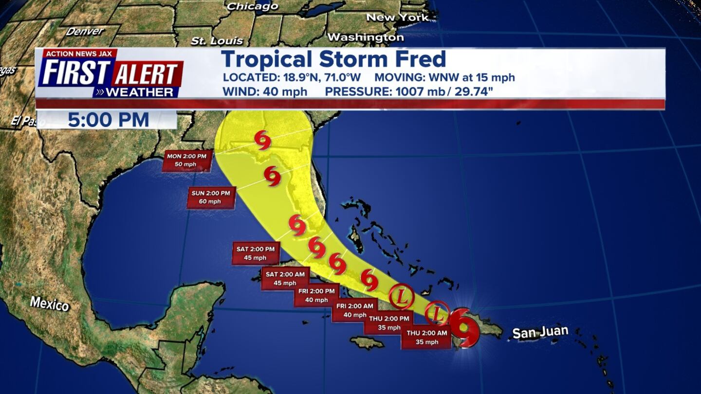
Tropical Storm Fred has made landfall near Cape San Blas, Fla. in the Panhandle. It’s about 80 miles SW of Tallahassee, a little more than 200 miles from Jacksonville with estimated winds near 65 mph.
#Fred makes landfall near Cape San Blas, Fl. in the Panhandle about 80 miles SW of Tallahassee, a little more than 200 miles from Jacksonville with estimated winds near 65 mph @woknvews #FirstAlertWx pic.twitter.com/qevvmjDZZO
— Mike Buresh (@MikeFirstAlert) August 16, 2021
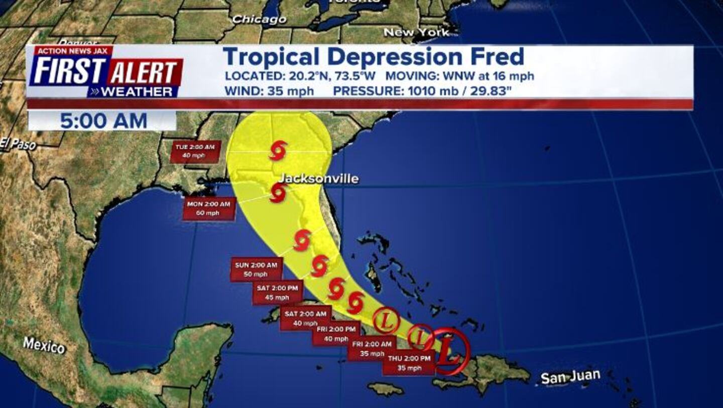
UPDATE 8/16, 5 a.m.
Fred is moving towards the Florida Panhandle Monday afternoon. Heavy rainfall and a dangerous storm surge are expected on the coast of the Florida Panhandle.
5 am advisory for tropical storm #Fred. No big changes. #FirstAlertWX pic.twitter.com/Q7VQsoXx46
— Garrett Bedenbaugh (@wxgarrett) August 16, 2021
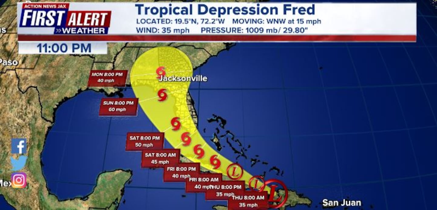
UPDATE 8/15, 11 p.m.
Tropical Storm Fred continues to get stronger. Heavy rainfall and a dangerous storm surge is expected along the coast of the Florida Panhandle and Big Bend beginning Monday.
UPDATE 8/15, 5 p.m.
Tropical Storm Fred has strengthened a little as it moves NNW. Fred is expected to make landfall along the Panhandle around Monday evening.

UPDATE 8/15, 11 a.m.
Fred is a tropical storm again. Tropical Storm Warnings issued for the Florida Panhandle.
UPDATE 8/14, 11 p.m.
The remnants of Fred are expected to re-develop into a tropical storm over the Gulf of Mexico Sunday.
UPDATE 8/14, 5 p.m.
What’s left of Fred is moving WNW across Southeast Gulf of Mexico. Fred has shifted west again and is likely to slowly organize back to a tropical storm Sunday before making landfall on Monday.
UPDATE 8/14, 11:45 a.m.
Tropical depression Fred is approaching the eastern Gulf as Mexico as a disorganized storm early afternoon Saturday.
Action News Jax Chief Meteorologist Mike Buresh is tracking Fred and Grace in his weather blog Talking the Tropics with Mike
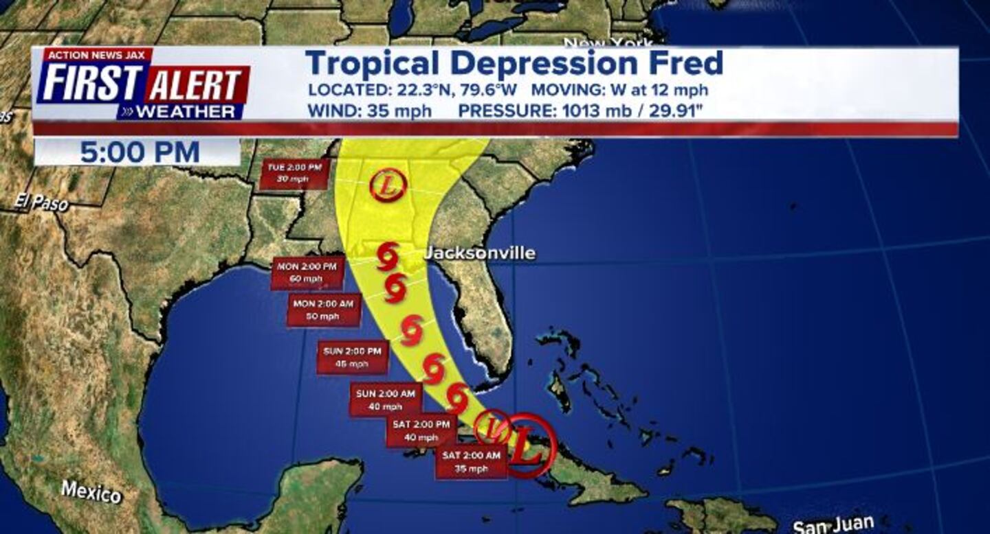
Friday 8/12, 5 p.m.
Fred formed late Tuesday night as a tropical storm just south of Puerto Rico and weakened to a tropical depression by Wednesday night. It’s the sixth named storm of the 2021 Atlantic season.
Action News Jax Chief Meteorologist Mike Buresh said that based on Fred’s current forecast, northeast Florida can expect several heavy bands of showers and thunderstorms Sunday through Tuesday.
Tracking Fred: How to stay informed about the storm with Action News Jax
You can learn more and stay updated with the most accurate information with Talking the Tropics With Mike.
As new updates about the storm are made available, we will provide them below:
UPDATED 8/13, 11 a.m.
The latest forecast track for Fred shows it has nudged left a bit for the landfall point in the Central Panhandle. It remains a tropical depression but is forecast to strengthen to a tropical storm by Saturday morning.
UPDATED 8/13, 8 a.m.
Tropical Depression Fred’s center is near the northern coast of Cuba. it remains poorly organized.
UPDATED 8/13, 5 a.m.
Tropical Depression Fred is forecast to become a tropical storm once again. A tropical storm warning has been issued for the Florida Keys and Florida Bay area. A tropical storm watch has been extended toward Bonita Beach to Englewood, Florida.
Fred will bring heavy rain to parts of Cuba as it passes near the island.
The Tropical Storm Watch for the Florida Keys and Florida Bay has
— Garrett Bedenbaugh (@wxgarrett) August 13, 2021
been upgraded to a Tropical Storm Warning.
The Tropical Storm Watch has been extended northward from Bonita
Beach to Englewood, Florida. pic.twitter.com/py4DYy6yF8
UPDATE 8/12, 11 p.m.
Tropical Depression Fred is spreading south to north. Heavy rain, gusty winds and isolated tornadoes can still be expected for much of Florida.

UPDATE 8/12, 5 p.m.:
A Tropical Storm Watch has been issued for the Florida Keys and the Southwest Coast of the Florida Peninsula, including Florida Bay.
Tropical Depression Fred shifted a little to the west, with a slower forward motion at WNW 12 mph.
UPDATE, 8/12, 1:20 p.m.:
First Alert Meteorologist Alyssa Pejic said Fred remains poorly organized and is still a tropical depression as of the 11 a.m. National Hurricane Center update. Intensity forecast is similar to previous forecast & new track has changed very little but it did shift slightly west.
11 AM TRACK UPDATE || Fred remains poorly organized & remains a tropical depression. Intensity forecast is similar to previous forecast & new track has changed very little but did shift slightly west!#FirstAlertWx pic.twitter.com/nuTNOFVnKx
— Alyssa Pejic (@AlyssaPejicWx) August 12, 2021
UPDATE, 8/12 8 a.m.:
The 8 a.m. advisory showed no major changes to Tropical Depression Fred.
8 am advisory is in for TD #Fred.
— Garrett Bedenbaugh (@wxgarrett) August 12, 2021
No big changes. #FirstAlertWX pic.twitter.com/4PRBi03LmI
UPDATE, 8/12 5 a.m.:
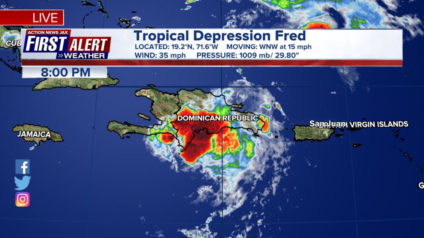
Tropical Depression Fred moves back over water between Cuba, Haiti, and the southern Bahamas. Fred remains poorly organized bringing heavy rain over portions of Hispaniola.
Tropical depression #Fred is now back over the water after exiting Haiti. It remains poorly organized as of now. #FirstAlertWX @ActionNewsJax @WOKVNews pic.twitter.com/aLUkuQ8Jmi
— Garrett Bedenbaugh (@wxgarrett) August 12, 2021
UPDATE, 8/11 11 p.m.:
Fred remains a Tropical Depression with little change from the 8 p.m. update. Chief Meteorologist Mike Buresh says there will be a lot of land interaction throughout the weekend, with local impacts expected between Sunday and Monday.
#firstalertwx #Fred 11pm Advisory Wed., 08/11 - lots of land interaction through the weekend - heavy rain/flooding the primary hazard along with isolated tornadoes @ActionNewsJax @WOKVNews pic.twitter.com/YFcGcvfN8k
— Mike Buresh (@MikeFirstAlert) August 12, 2021
UPDATE, 8/11 8 p.m.:
Due to land interaction, Fred has weakened to a Tropical Depression over Hispaniola.
UPDATE, 8/11 5:00 p.m.:
Tropical Storm Fred’s winds have decreased to 40 mph. It is moving ashore over Hispaniola on Wednesday and over Haiti during the evening hours. Based on the projected track, the system is expected to bring fringe impacts to Northeast Florida and Southeast Georgia.
Update, 8/11 2:00 p.m.:
Tropical Storm Fred’s winds remain at 45 mph.
Update, 8/11 11:00 a.m.:
Tropical Storm Fred is nearing the Dominican Republic and eyeing the eastern Gulf of Mexico. Wind speeds are now up to 45 mph. Given the current forecast, Meteorologist Corey Simma said the local area will see some bands of heavy rain Sunday/Monday.
11 AM Update: #Fred nearing the Dominican Republic, eyeing the Eastern Gulf of Mexico #FirstAlertWX pic.twitter.com/XKoi5Gdfq6
— Corey Simma (@CSimmaWX) August 11, 2021
Update, 8/11 8:00 a.m.:
There were no significant changes in the 8 a.m. advisory for Tropical Storm Fred.
The storm’s center is just south of the eastern Dominican Republic.
Wind speeds are at 40 mph.
8 am advisory for #Fred: no big changes. #FirstAlertWX pic.twitter.com/F5K2T4YCUW
— Garrett Bedenbaugh (@wxgarrett) August 11, 2021
Update, 8/11 5:00 a.m.:
5 am advisory is in for tropical storm #Fred. #FirstAlertWX @ActionNewsJax @WOKVNews #FLwx pic.twitter.com/TePsDGig0b
— Garrett Bedenbaugh (@wxgarrett) August 11, 2021
RELATED STORIES:
Talking the Tropics With Mike: Fred forms near Puerto Rico
Original Story 8/11 4 a.m.:
The Action News Jax First Alert Weather team is tracking Tropical Storm Fred which formed just south of Puerto Rico.
Fred will hit portions of Hispaniola today and is expected to weaken.
Fred’s current forecast track has the cone hitting Florida this weekend.
All morning long -- I am tracking tropical storm #Fred in the Caribbean. Fred will move over Hispaniola today and head back into the Atlantic. With the latest track... we could see some local fringe impacts over the weekend. See you on TV. @ActionNewsJax #FirstAlertWX pic.twitter.com/q0obs3yJRs
— Garrett Bedenbaugh (@wxgarrett) August 11, 2021
©2021 Cox Media Group


