
Jacksonville, Fl. — The “Buresh Bottom Line”: Always be prepared!.....First Alert Hurricane Survival Guide... City of Jacksonville Preparedness Guide... Georgia Hurricane Guide.
STAY INFORMED: Get the * FREE * First Alert Weather app
FREE NEWS UPDATES, ALERTS: Action News Jax app for Apple | For Android
WATCH “The Ins & Outs of Hurricane Season”
WATCH “Preparing for the Storm”
READ the First Alert Hurricane Center “Survival Guide”
***** ALWAYS CHECK & RE-CHECK THE LATEST FORECAST & UPDATES! *****
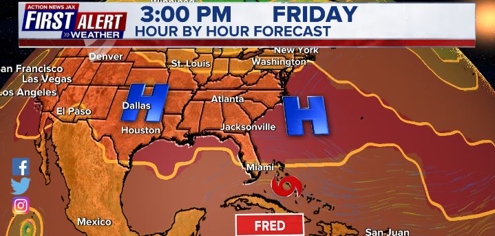
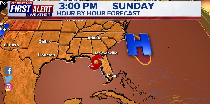
Potential local - Jax/NE Fl./SE Ga. impacts from“Fred” BASED ON CURRENT FORECAST:
* increase in tropical moisture late in the weekend into early next week
* several heavy bands of showers & t’storms Sunday/Mon./Tue.
* isolated waterspouts & tornadoes
* a little breezy
* little or no storm surge
* CHECK BACK FOR UPDATES!!
The strong tropical wave entered the NE Caribbean Tue. & was upgraded south of Puerto Rico to tropical storm “Fred” Tue. evening - the 6th named storm of the Atlantic season & about 2 1/2 weeks ahead of the avg. date of Aug. 28th. The avg. date for the first hurricane, by the way, is Aug. 10th. Elsa briefly became a hurricane in early July. Back to Fred - forecast models have come into pretty decent agreement on development as well as on the track & speed.
Fred will move steadily west/northwest with a center that might have a tendency to “jump around” a bit until & unless a decent inner core is established. Fred will slow by late in the week into the weekend as the storm rounds the western edge of the expansive Bermuda High. One of the greater complicating factors is land interaction including Puerto Rico & Hispaniola & possibly Cuba. There is also a fair amount of dry air to overcome though overall conditions to become more favorable later in the week. It would appear that the poorly organized center will largely avoid Puerto Rico & likely not spend a lot of time over the Dominican Republic, so Fred may emerge over the far SW Atlantic in relatively “decent” shape. Both the GFS & European have initialized well & bring the system through the Florida Straits over the weekend & to the Eastern Gulf of Mexico but the European model remains slower & a little more west while the GFS is a little faster & a little more north & east. The GFS has had a right/east bias the last couple of weeks with tropical cyclones over the E. Pacific, but the model was a clear “winner” during Elsa 4-5 weeks ago. A stronger ridge seems to be the most logical forecast right now given how stout the ridge has been since essentially May. As such, at least a somewhat more westward track - before turning more north - seems to be the way to go right now.
So.... tropical storm conditions will occur over some of the Greater Antilles the next few days but with improving conditions for Puerto Rico by late Wed. while squalls & strong winds affect Hispaniola & the north & east coasts of Cuba. A tropical system/cyclone of “some sort” will be near Fl. & the Eastern Gulf over the weekend into early next week.
I cannot emphasize this enough: stay tuned & stay up to date on the latest forecasts.


Spaghetti plots including ensemble forecasts for Fred:


Some dry air in the vicinity of the disturbance but more moisture with time to the northwest:


A “zone” of strong shear - 30-40 mph - extends from the Caribbean to the Central Atlantic which ‘94-L’ will have to traverse Wed.-Thu.:

500 mb (~30,000 feet) GFS forecast - the Bermuda High will be critical!:
Elsewhere - another strong tropical wave has come off the coast of Africa & bears watching.


We’re now just 5 weeks from the peak of the hurricane season (Sept. 10), so just from a climatological point, we should see an uptick in Atlantic activity. But there are also other indications of a more active period or “burst” with the MJO, seasonally warm sea surface temps. & rather impressive deep oceanic heat content.
Sea surface temps. across the Atlantic are now near to above avg. across much of the basin (2nd image below) & - even more importantly - deep oceanic heat content is becoming impressive & the “equivalent oceanic heat content” - namely depth averaged temperature in the upper 300 m (~984 feet) - is even more impressive all the way from Africa to the Gulf of Mexico. Such an ocean water temp. pattern is conducive to long track deep tropical Atlantic tropical cyclones & can lead to a more favored regime for rapid intensification cycles. From an AMS research paper in ‘08 Mainelli, DeMaria, Shay, Goni: “Results show that for a large sample of Atlantic storms, the OHC variations have a small but positive impact on the intensity forecasts. However, for intense storms, the effect of the OHC is much more significant, suggestive of its importance on rapid intensification. The OHC input improved the average intensity errors of the SHIPS forecasts by up to 5% for all cases from the category 5 storms, and up to 20% for individual storms, with the maximum improvement for the 72–96-h forecasts. The statistical results obtained indicate that the OHC only becomes important when it has values much larger than that required to support a tropical cyclone.” More recent research continues to indicate similar correlations.


Saharan dust. Dry air - yellow/orange/red/pink. Widespread dust is most common earlier in the hurricane season & is indicative of dry air that can impede the development of tropical cyclones. However, sometimes “wanna’ be” waves will just wait until they get to the other side of the plume then try to develop if everything else happens to be favorable.

2021 names..... “Grace” is the next name on the Atlantic list (names are picked at random by the World Meteorological Organization... repeat every 6 years... historic storms are retired (Florence & Michael in ’18... Dorian in ’19 & Laura, Eta & Iota in ‘20). Last year - 2020 - had a record 30 named storms. The WMO decided beginning in 2021 that the Greek alphabet will be no longer used & instead there will be a supplemental list of names if the first list is exhausted (has only happened twice - 2005 & 2020). More on the history of naming tropical cyclones * here *.


East Atlantic:


Mid & upper level wind shear (enemy of tropical cyclones) analysis (CIMMS). The red lines indicate strong shear:
Water vapor imagery (dark blue indicates dry air):

Deep oceanic heat content continues to increase across the Gulf, Caribbean & deep tropical Atlantic & has become pretty impressive from the Central/NW Caribbean into the Gulf of Mexico:

Sea surface temp. anomalies:

SE U.S. surface map:

Surface analysis centered on the tropical Atlantic:

Surface analysis of the Gulf:

Caribbean:

Atlantic Basin wave forecast for 24, 48 & 72 hours respectively:


The East Pacific - Kevin & Linda:


West Pacific IR satellite:

Global tropical activity:


Cox Media Group


