
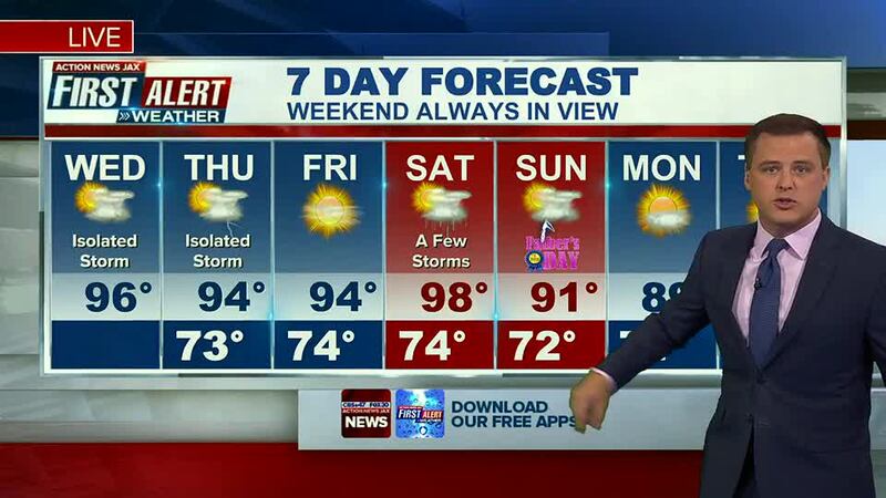
Jacksonville, Fl — Today will be partly sunny and hot. Highs will reach the mid to upper 90s. It will “feel like” 105-110 this afternoon with the humidity in Jacksonville.
Tuesday was the hottest afternoon in more than a year - we hit 96 at JAX Airport. These are still below record lows, which are 100+. But it’s hotter than the average of 90 degrees.
LISTEN: Mike Buresh ‘All the Weather, All the Time’ Podcast
A few isolated showers or storms will try to develop inland between 1 and 4 pm. Locally heavy rain, lightning and a few gusty winds are possible.
We will reach the lower to mid 90s again in Jacksonville tomorrow as a ridge of high pressure dominates the weather across the Southeast this week. A few afternoon storms are still possible to cool some neighborhoods down, temporarily.
We hang onto the summer like heat into the weekend. But there may be more widespread rain and storms.
TROPICS: The First Alert Weather Team is tracking a small area of low pressure with disorganized showers and storms over the Southwestern Caribbean. Some gradual development is possible as it moves northwestward through this week. Hurricane Hunters are scheduled to investigate later today. This feature should stay well to our south and west.
Hot. #FirstAlertWX pic.twitter.com/6XCMdB01bE
— Garrett Bedenbaugh (@wxgarrett) June 15, 2022
The heat is on. #FirstAlertWX pic.twitter.com/10UCHGfLLL
— Garrett Bedenbaugh (@wxgarrett) June 15, 2022
Good morning! I'm tracking feels like temperatures above 110 degrees this afternoon. Get the updated First Alert Forecast on FOX30 and CBS47 Action News JAX This Morning from 4:30 - 9 am! #FirstAlertWX pic.twitter.com/0OH4FHpzsf
— Garrett Bedenbaugh (@wxgarrett) June 15, 2022
Another hot one today. #FirstAlertWX pic.twitter.com/4uGqf9immm
— Garrett Bedenbaugh (@wxgarrett) June 15, 2022
©2022 Cox Media Group


