:quality(70)/cloudfront-us-east-1.images.arcpublishing.com/cmg/4BY52YP3URHB3CBG6342FEUNGQ.jpg)
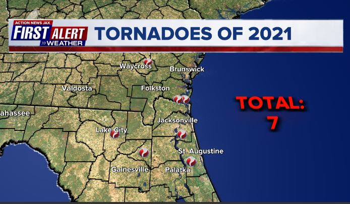
Jacksonville, FL — For Jacksonville... 2021 was slightly cooler (-0.04 degrees) than avg. - but did include 6 straight months with below avg. temps. [heavily offset by a very warm Dec.] - & a bit wetter (+4.1″). There were 13 record temps. throughout the year - 5 record highs, 3 record lows, 3 record high lows & 2 record low highs. There were 3 days with daily rainfall records. There were “only” 65 90-degree days for the year - well below the average of 82 90-degree days.
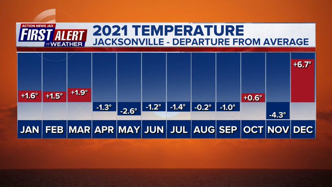
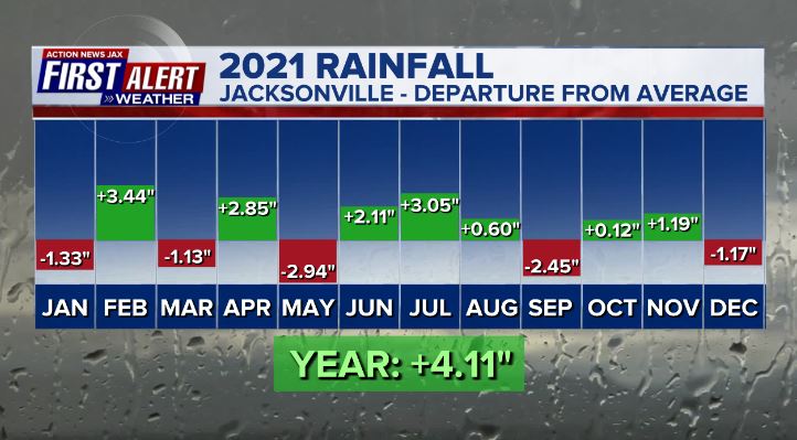
Month by month weather highlights (first # after each month is the avg. temp./deviation from avg... 2nd number is the rainfall/deviation from avg.):
JANUARY... 54.7 degrees/+1.6 degrees... 1.97″/-1.33″
1st: tie record high low at 66 degrees
FEBRUARY... 57.9 degrees/+1.5 degrees... 6.63″/+3.44″ - 10th wettest Feb. on record
6th: 2-4″ of rain across Southern Duval/St. Johns/Clay & Bradford Co.
5th - 12th: Nocatee - 6.51″ of rain
14th: Daytona 500 delayed by rain for 6 hours ending after midnight
15th: Scattered severe storms produced pockets of heavy rain, gusty winds
16th: Record arctic blast from Iowa to Texas
18th: Jacksonville ties record high of 86 degrees (2019)
MARCH... 63.6 degrees/+1.9 degrees... 2.82″/-1.13″
26th: Jax record high of 90 (88/1965)
31st: Tie record high of 89 (2020)
APRIL... 65.7 degrees/-1.3 degrees... 5.49″/+2.85″
2nd: 56 degrees - ties record low high for the date (1915) - 6th lowest April high on record for Jax
3rd: 36 degrees - record low (39/1962)
10th: 60 mph t’storm wind gust at JIA
22nd: 64 degrees ties record low high (2013)
24th: 1.58″ of rain at JIA... severe storms across SE Ga.
MAY... 72.3 degrees/-2.6 degrees... 0.48″/-2.94″ - 11th coolest May on record... 4th driest May... coolest spring (March/April/May) since 2013... 30th coolest spring overall
4th: 93 degrees ties daily record high (2006)
13th: 69 degrees - record low high for the day (70/1903)
15th: 49 degrees - record low (52/2013)
16th: 50 degrees - record low (52/2011)
22nd: Rip current death - Huguenot Park... Subtropical storm “Ana” forms northeast of Bermuda & dissipates the next day.
24th: Rip current death - Fernandina Beach
JUNE... 79.1 degrees/-1.2 degrees... 9.71″/+2.11″
12th - 30th: At least a trace of rain each day at JIA
30th: Middle of brutal & record setting 2 week heatwave in the Pacific Northwest (June 23 - July 7)
Christopher Harley/University of British Columbia - hundreds of thousands of dead mussels after heat wave:

JULY... 81.1 degrees/-1.4 degrees... 8.87″/+2.10″
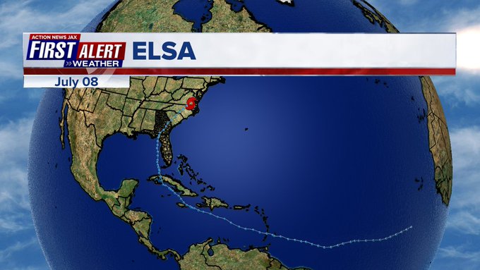
1st: Tropical storm “Elsa” forms over the Central Atlantic east of the Windward Islands of the Caribbean
5th: T.S. Elsa hits Cuba
7th: T.S. Elsa landfall at the Big Bend of Florida while moving NE. Produces EF-1 tornado in Jacksonville... EF-1 tornado in SE Ga. at Kings Bay Base... Daily record rainfall at JIA of 2.66″ (2.07″/1963).... see “Buresh Blog” for a summary of Elsa & its impacts.
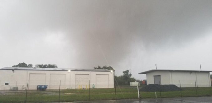
Security footage of Jacksonville tornado:
:quality(70)/d1hfln2sfez66z.cloudfront.net/07-08-2021/t_d2125a7d4bbb40d08d38163eda0231d0_name_file_960x540_1200_v3_1_.jpg)
19th: 3.01″ of rain at JIA - daily record rainfall (2.17″/1936)
26th: 1-5″ of rain across Eastern Duval, St. Johns Co. due to tropical disturbance (’90-L’)
AUGUST... 81.9 degrees/-0.2 degrees... 7.48″/+0.60″... June/July/Aug. (summer) - “only” 49 90-degree days vs. avg. of 60 days - “coolest” since 2012... 63 t’storm days vs. avg. of 49 t’storm days.
21st: Waverly, Tennessee flash flood kills 20+
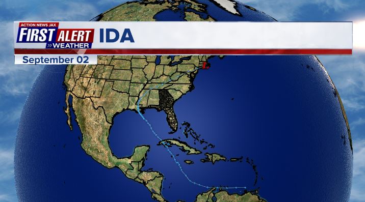
26th: Tropical storm Ida forms over the NW Caribbean
29th: Rapidly intensifying Cat. 4 Ida landfall over Southeast Louisiana
30th: Lake Tahoe evacuated due to nearby wildfire
SEPTEMBER... 77.9 degrees/-0.9 degrees... 5.11″/-2.45″
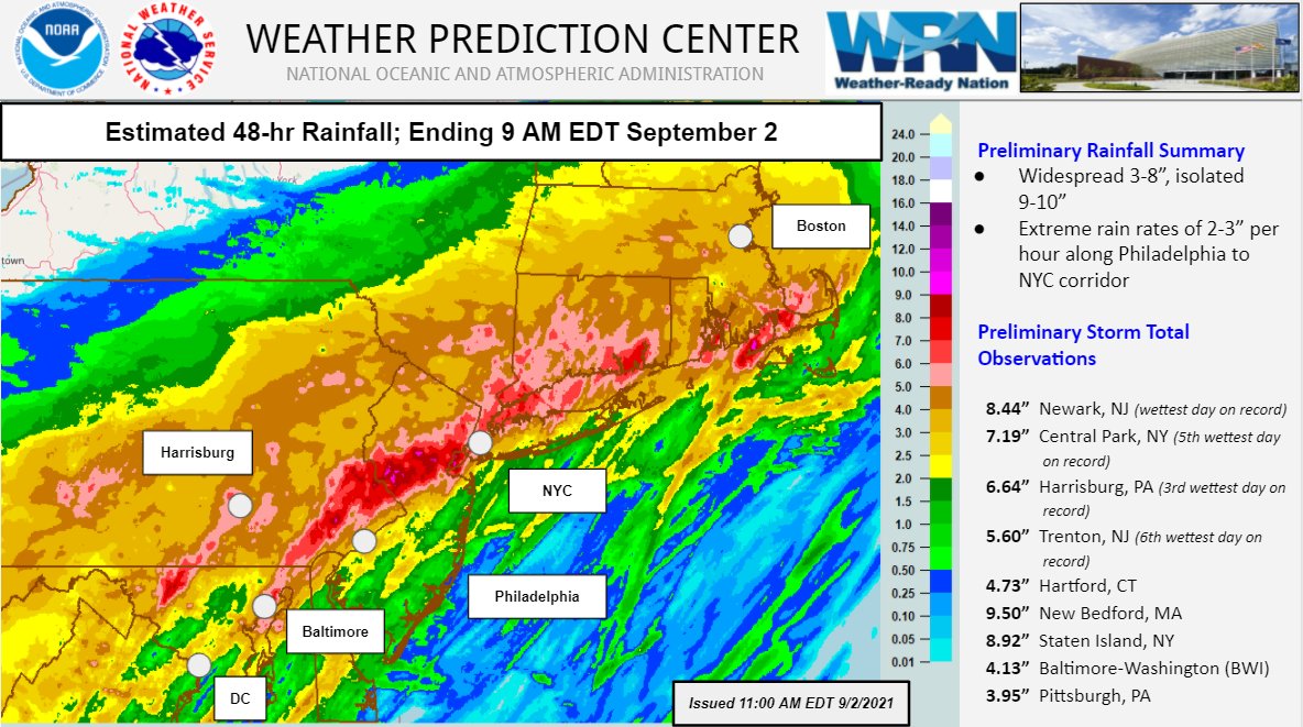
2nd: Ida remnants produce severe flash flooding across the Northeast U.S. including New York City killing 40+
8th: Tropical storm “Mindy” landfall in the Central Fl. Panhandle causing little damage... weak system passed north of Jacksonville through the day
16th: 3-5″ of rain - Northern Duval Co. closes I-295N/I-95N for a time due to mudslide.
OCTOBER... 71.8 degees/+0.6 degrees.. 4.15″/+0.12″
NOVEMBER... 58.0 degrees/-4.3 degrees... 3.19″/+1.19″ - 7th coolest Nov. on record
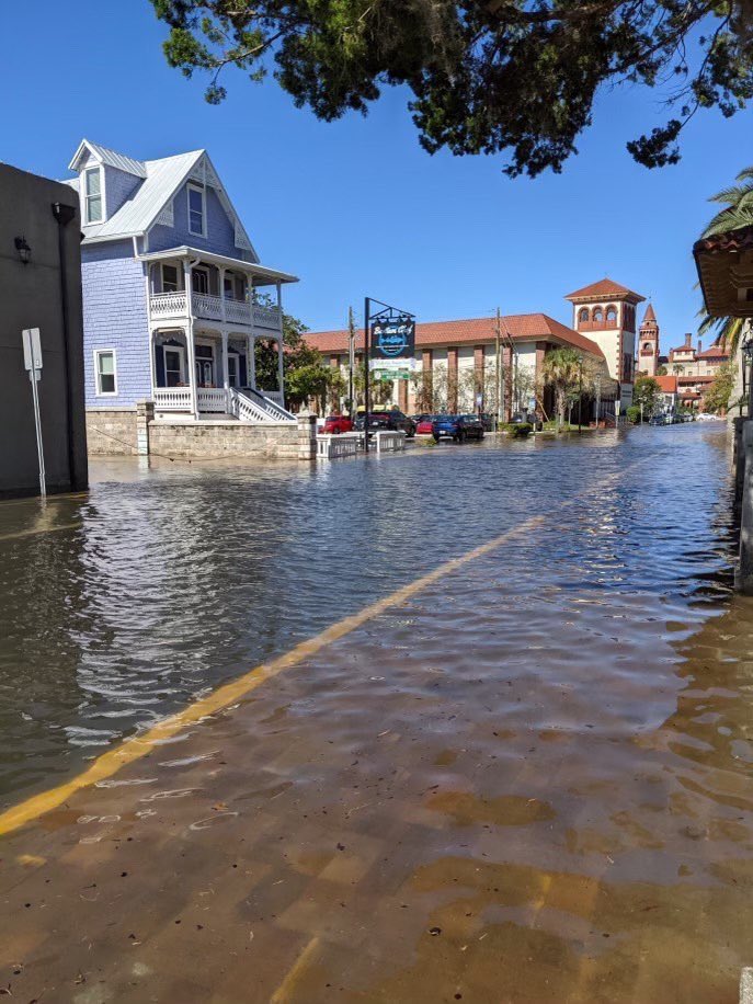
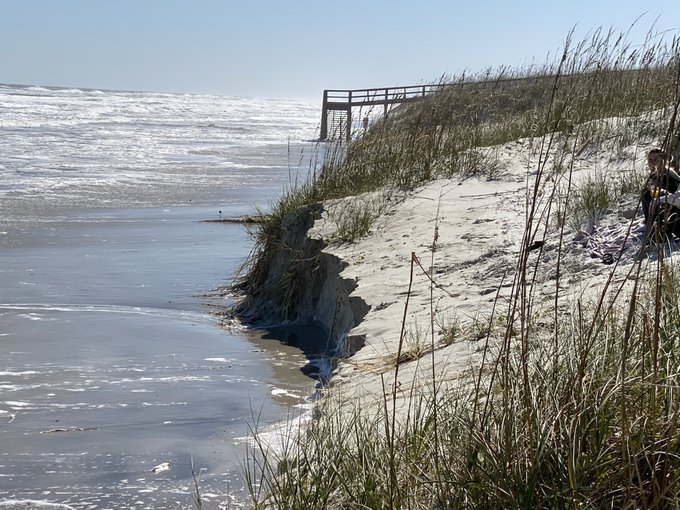
5th-6th: Major nor’easter (see “Buresh Blog”) causes local flooding, strong winds & severe beach erosion

6th: 2.49″ of rain at JIA - daily record (1.92″/1880)... record low high of 51 degrees (53 degrees/1953)
10th: No global Cat. 3 or stronger tropical cyclone since Sept. 26th - 1st time since at least 1950... recap of the ‘21 Atlantic hurricane season - “Talking the Tropics With Mike”.
30th: End of the ‘21 Atlantic hurricane season. From Dr. Phil Klotzbach: “The globe has had no major (Category 3+, max winds >=111 mph) hurricane/typhoon/cyclone formations since September 25. All other hurricane seasons in the satellite era (since 1966) have had at least two global major hurricane formations between September 26 - November 30.”
DECEMBER... 63.4 degees/+6.7 degrees... 1.61″/-1.17″
6th: 80 degrees at JIA - 71st straight month with at least one 80-degree day
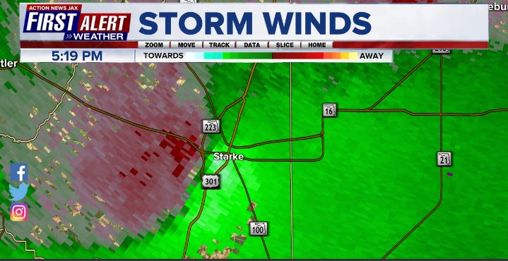
8th: EF-1 tornado hits Starke, Fl.
:quality(70)/cloudfront-us-east-1.images.arcpublishing.com/cmg/JCKAG6BWKBHODCJNYVDR6DDANA.jpg)
First Alert Doppler radar velocity showing Starke tornado:
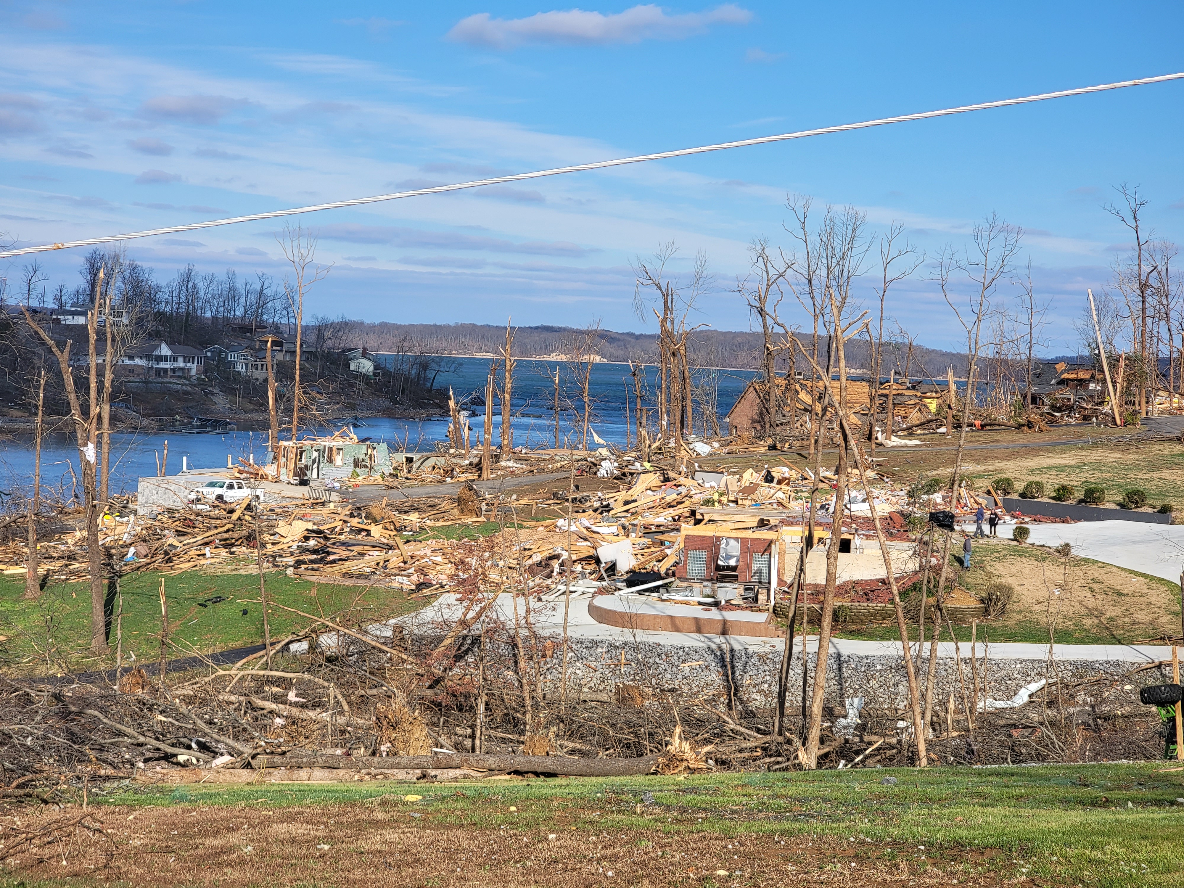
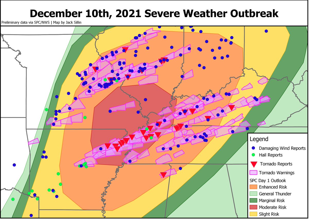
10th: Violent tornado outbreak from Louisiana to Missouri & Illinois centered on Tennessee & especially Kentucky - 80+ dead.
11th: 83 degrees - ties record high (1971)
15th: “Serial” derecho - with numerous tornadoes & wind gusts of 70+ mph - races across the Midwest from Nebraska & Kansas to Minnesota & Wisconsin - first Dec. derecho in the Lower 48
#Derecho timelapse of NEXRAD, SVR+TOR warnings, and thunderstorm wind reports (LSR: TSTM WND GST). Bottom axes is an attempt to show the time coverage of the reports with each bar being 5 minutes wide, so no gaps until ~11 PM. Can iterate if folks have ideas. pic.twitter.com/Ex2EQsZNzW
— daryl herzmann (@akrherz) December 20, 2021
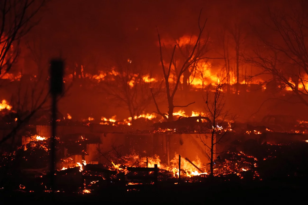
30th: Massive & historical wildfires near Boulder, Co. - called the “worst & costliest” wildfire in state history. Associated Press pic below:
31st: Jacksonville record of 83 degrees (82/1988) & tied record high low of 67 degrees (2015)
©2021 Cox Media Group
:quality(70)/d1hfln2sfez66z.cloudfront.net/04-19-2024/t_744a0fe392b04fa194c322a11f1cea0c_name_file_960x540_1200_v3_1_.jpg)
:quality(70)/cloudfront-us-east-1.images.arcpublishing.com/cmg/YZRADLE76ZHWFLUIEFUTQ4EVR4.jpg)
:quality(70)/cloudfront-us-east-1.images.arcpublishing.com/cmg/SKFDOR2IYNE4NDKFR6PGKELN3E.png)
:quality(70)/cloudfront-us-east-1.images.arcpublishing.com/cmg/N7YMXJTJYJEFBCXSUI6KPLO7OM.png)
:quality(70)/d1hfln2sfez66z.cloudfront.net/04-19-2024/t_fc72695bddad400cbcdf60101dc0389b_name_file_960x540_1200_v3_1_.jpg)