JACKSONVILLE, Fla. — Action News Jax’s First Alert Weather Team is tracking a warming trend that will last through the rest of the week.
According to First Alert Meteorologist Garrett Bedenbaugh, it will be mainly dry on Wednesday with highs in the mid to upper 80s inland and the lower 80s at the coast.
WATCH THE FORECAST | DOWNLOAD THE APPS
The lower 90s will return on Thursday and will linger through the holiday weekend.
An isolated shower is possible on Saturday, and Memorial Day will be hot with highs in the lower to mid-90s.
Action News Jax’s First Alert Weather Team will continue to monitor the forecast and will bring you updates throughout the day.
Follow Action News Jax Meteorologists on Twitter for updates:
Mike Buresh | Garrett Bedenbaugh | Corey Simma | Trevor Gibbs
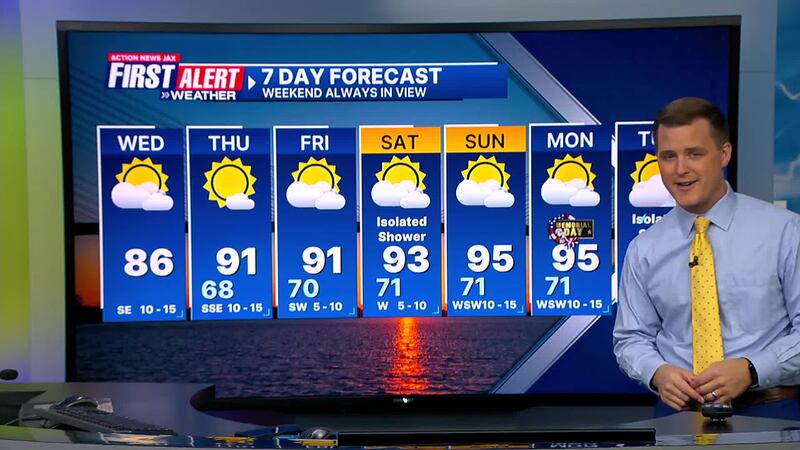
Here’s a look at your First Alert 7-Day Forecast:
TODAY: Partly sunny and warm. HIGH: 86
TONIGHT: Mostly clear. LOW: 68
LISTEN: Mike Buresh ‘All the Weather, All the Time’ Podcast
THURSDAY: Partly sunny. High 91/Low 68
FRIDAY: Partly sunny and hot. High 91/Low 70
SATURDAY: Partly sunny. Isolated afternoon shower. High 93/Low 71
SUNDAY: Partly sunny. High 95/Low 71
MEMORIAL DAY: Partly sunny and hot. High 95/Low 71
TUESDAY: Partly sunny with and isolated afternoon storm. High 94/Low 72
INTERACTIVE RADAR: Keep track of the rain as it moves through your neighborhood
SHARE WITH US: Send us photos of the weather you’re seeing in your area


