JACKSONVILLE, Fla. — Action News Jax’s First Alert Weather Team is tracking cooler temperatures coming in as we near the weekend.
Wednesday morning started in the 50s and 60s behind an expected cold front that the First Alert Weather Team has been tracking all week.
Winds are expected to pick up out of the northeast at 15-20 mph with higher gusts, especially at the coast.
WATCH THE FORECAST | DOWNLOAD THE APPS
Afternoon temperatures today will only be in the lower to mid-60s, which is 20+ degrees cooler than yesterday afternoon.
A few coastal showers are possible Thursday in St. Johns County with onshore winds. More showers will move into the overarching area by Friday and into the weekend, and an evening storm is possible.
Action News Jax’s First Alert Weather Team will continue to monitor the forecast and give you updates throughout the day.
Follow Action News Jax Meteorologists on Twitter for updates:
Mike Buresh | Garrett Bedenbaugh | Corey Simma | Trevor Gibbs
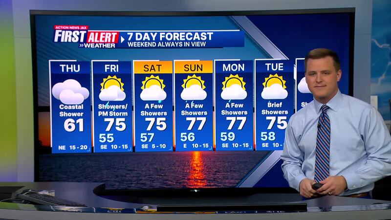
Here’s a look at your First Alert 7-Day Forecast:
TODAY: Cloudy and breezy. Brief St. Johns County shower at the coast. THIS AFTERNOON: 61 (Official high likely has been overnight before cold frontal passage: 68)
TONIGHT: Mostly cloudy. Isolated coastal sprinkle/shower. LOW: 55
LISTEN: Mike Buresh ‘All the Weather, All the Time’ Podcast
FRIDAY: Mostly cloudy with a few showers. PM Storm. High 75/Low 55
SATURDAY: Partly cloudy with a few showers. High 75/Low 57
SUNDAY: Partly cloudy. A few brief showers. High 77/Low 56
MONDAY: Mostly cloudy with a few showers. High 77/Low 59
TUESDAY: Mostly cloudy with a brief shower. High 75/Low 58
WEDNESDAY: Partly cloudy. Scattered showers/storm. High 74/Low 59
INTERACTIVE RADAR: Keep track of the rain as it moves through your neighborhood
SHARE WITH US: Send us photos of the weather you’re seeing in your area


