:quality(70)/cloudfront-us-east-1.images.arcpublishing.com/cmg/WW5AJL3ARQUGDQMAQUNSFX4CLE.jpg)
Jacksonville, Fl. — The “Buresh Bottom Line”: Always be prepared!.....First Alert Hurricane Survival Guide... City of Jacksonville Preparedness Guide... Georgia Hurricane Guide.
STAY INFORMED: Get the * FREE * First Alert Weather app
FREE NEWS UPDATES, ALERTS: Action News Jax app for Apple | For Android
WATCH “Talking & Tracking the Tropics: The Science Behind the Season”
WATCH “Preparing for the Storm”
READ the First Alert Hurricane Center “Survival Guide”
***** ALWAYS CHECK & RE-CHECK THE LATEST FORECAST & UPDATES! *****
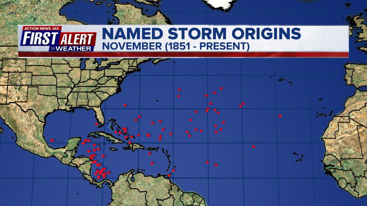
The Caribbean & SW Atlantic will remain areas to keep an eye on for tropical development into November (climatologically favored too).
Tropical depression #29 was upgraded Sat. afternoon & to tropical storm Eta Sat. evening then to a hurricane (12th of the Atlantic season) early Mon. & so Eta becomes the record-tying storm for most in a single season. Squalls of heavy rain & gusty winds will continue across Jamaica into Mon. night but Eta’s main target is Nicaragua & Honduras as a hurricane - possibly a Cat. 3 - by Tue. where there is the potential for extreme rainfall on the order of 3 feet! thanks to very slow movement & mountainous terrain. Conditions (shear, water temps., moisture) all appear favorable for steady if not rapid strengthening right up to landfall which has been a hallmark of this season. On this track, there would be no impact to Jacksonville/NE Fl./SE Ga. or any of the U.S. (for a change!) BUT......
The ultimate outcome of where Eta goes & how it gets there is becoming more & more muddled by the day. The GFS has been rather emphatic that Eta would only make it to the Central American coast or slightly inland before turning some semblance of north & east & back over the Caribbean. The European model & UKMET were not indicating such as these models have been taking Eta solidly inland over Central America.... even into the E. Pacific eventually. Then developing a second & separate system to the east. The UKMET continues with this solution developing the 2nd system over the far Northwest Caribbean by the weekend. But recent trends by the European in particular are trending toward the GFS solution. The Euro has Eta still moving inland over Nicaragua & Honduras but then turns the system north/northeast moving back over the Caribbean by late week/the weekend.
So.... we have a conundrum when it comes to the ultimate outcome with Eta. I suspect - either way - whether it’s Eta or a separate 2nd tropical cyclone - we will have a tropical threat to parts of the Caribbean &/or Southeast U.S., possibly including Florida - between Nov. 8 & Nov. 18th
Forecast models seem to be struggling with “all the low pressure” at low latitudes including the tropics. So we’ll see a good deal of changes & fluctuations in the forecast models in the coming days with - at times - some fairly wild “end games” / solutions with where tropical systems might go & strong they might be. No need to panic & certainly no time to jump on individual model runs though I suspect we will see such on social media & within some media/weather “circles”.
A tropical system moving north out of the Caribbean becomes a very viable concern by next weekend & beyond as the upper level flow goes back to what we’ve seen most of the hurricane season. A trough over/near the Central U.S. with increased ridging near Fl. or perhaps a little to the east. How this all evolves will be critical in steering whatever tropical systems are lurking. Stay tuned!
So... stay up to date on the latest forecasts & don’t fall asleep on the tropics as we start the last month of the official Atlantic hurricane season.


More spaghetti:


The upper level ridge - at least for now & through the middle of the week - is shifted south which steers Eta westward - to near Central America. However, the ridge will likely pop back north &/or northeast to some degree after this week which *could* open the door again for anything else that might develop over or near the Caribbean *or* even allow Eta to turn north & northeast in the long run.
The charts below are the upper levels (500mb) for Tue., Nov. 3rd & Sat., Nov. 7th respectively. The evolution of the degradation of the ridge of high pressure + how the upper level trough evolves to the north & west will be critical in where potential Caribbean tropical disturbances/systems (Eta or otherwise) go during the next 1-2 weeks.


Atlantic Basin wave forecast for 24, 48 & 72 hours respectively:


The next area to watch for possible additional tropical development will again be the Caribbean through the first 10 days or so of Nov.


:quality(70)/cloudfront-us-east-1.images.arcpublishing.com/cmg/SBDZ7P7DFJENRBFEBLGFQALTMY.jpeg)
:quality(70)/d1hfln2sfez66z.cloudfront.net/04-27-2024/t_a52b4340b0444d7ea55162aca9ac4b17_name_file_960x540_1200_v3_1_.jpg)
:quality(70)/cloudfront-us-east-1.images.arcpublishing.com/cmg/KTB7BBM3OBCU3CXXGQ2IZQMEKA.jpg)
:quality(70)/cloudfront-us-east-1.images.arcpublishing.com/cmg/QFUPI422BJG37L6ZX45RFE5MLU.png)
:quality(70)/cloudfront-us-east-1.images.arcpublishing.com/cmg/NELK3AEZLJHYBISNHYIBS26SNY.jpg)