:quality(70)/cloudfront-us-east-1.images.arcpublishing.com/cmg/JIFG55NSN5HKZK6LKEZ4C7UU5I.jpg)
Jacksonville, Fl. — The “Buresh Bottom Line”: Always be prepared!.....First Alert Hurricane Preparation Guide... City of Jacksonville Preparedness Guide... Georgia Hurricane Guide.
STAY INFORMED: Get the * FREE * First Alert Weather app
FREE NEWS UPDATES, ALERTS: Action News Jax app for Apple | For Android
WATCH “Preparing for the Storm”
WATCH “The Ins & Outs of Hurricane Season”
READ the First Alert Hurricane Center “Survival Guide”
LISTEN & WATCH “Surviving the Storm” - WOKV Radio & Action News Jax
***** ALWAYS CHECK & RE-CHECK THE LATEST FORECAST & UPDATES! *****
REMEMBER WHEN A TROPICAL STORM OR HURRICANE IS APPROACHING: Taping windows is *not* recommended & will not keep glass from breaking. Instead close curtains & blinds.
Realize the forecast cone (”cone of uncertainty”) is the average forecast error over a given time - out to 5 days - & *does not* indicate the width of the storm &/or where damage that might occur.

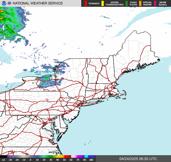
*** LOCAL (Jacksonville/NE Fl./SE Ga.) IMPACTS FROM THE TROPICS: Rough seas & surf through this week with a high rip current risk. Breakers at the beaches 5-7′, locally briefly higher through Fri. even as Lee moves away.
The Atlantic Basin Overview:
** “Lee” was upgraded to a tropical storm last Tue. afternoon & to a hurricane Wed. afternoon & intensified to a Cat. 4 Thu. afternoon & to a Cat. 5 late Thu. evening! before weakening the last several days... will be “on the field” through the upcoming weekend but will transition to post-tropical Fri./Fri. night.
** The strong tropical wave - ‘96-L’ was upgraded to tropical depression #14 Thu. morning & “Margot” Thu. afternoon then to a hurricane Mon. afternoon - stays far out to sea over the E. & Central Atlantic.
** A strong tropical wave moving into the Central Atlantic has a good chance to develop while northwest.
** A trailing strong tropical wave at a lower latitude closer to Africa has the potential for eventual development...

(1) The strong tropical wave - ‘95-L’ - that moved off the coast of Africa this past weekend and was upgraded to tropical depression #13 Tue. morning then to tropical storm “Lee” Tue. afternoon & then to a hurricane Wed. afternoon. The hurricane rapidly intensified Thu. becoming a Cat. 4 last Thu. afternoon then a Cat. 5 later Thu. night creating great hoopla & unwarranted scary headlines. Lee steadily weakened thereafter until strengthening again late Sun. into Monday & is now slowly weakening.
A Hurricane WATCH: Stonington, Maine to the U.S./Canada border ... New Brunswick from the U.S./Canada border to Point Lepreau, including Grand Manan Island ... Nova Scotia from Digby to Medway Harbour. A Tropical Storm WARNING: Bermuda ... Westport Massachusetts northward to the U.S./Canada border ... Martha’s Vineyard ... Nantucket ... New Brunswick from the U.S./Canada border to Fort Lawrence, including Grand Manan Island ... Nova Scotia from Fort Lawrence to Point Tupper.
Lee’s turn to the north has been completed, & the hurricane will now speed up on its journey to landfall by Fri. night/Saturday. The hurricane goes far - 800-1,000 miles - to the east of Fl. through Thu. night.
Lee was the third major (Franklin & Idalia so far) hurricane of the Atlantic season ... the third hurricane of the Atlantic season develops - on average - Sept. 7 (4 so far this year) while the 2nd “major” hurricane average date is Sept. 19.
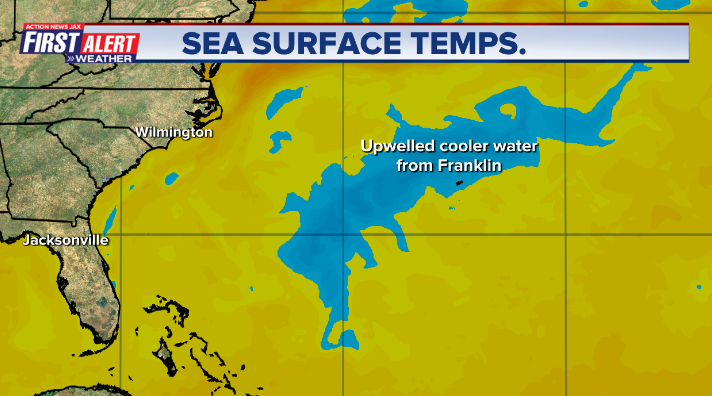
The transition from an intense, compact hurricane to a sprawling, not as powerful hurricane has been completed. Lee is moving over some of the cooled wake from Franklin & even Idalia. Nearby dry air has also been eating away at some of the circulation & mid & upper level wind shear is steadily increasing. Lee will remain a Cat. 1 followed by extra-tropical transition by at least Fri. night upon approach to the Gulf of Maine & Atlantic Canada.
Lee is gaining speed (forward movement) as it fully rounds the west side of the Bermuda high & starts to feel the “pulling” effects of an approaching upper level trough. This is still where the forecast track becomes more problematic & - ultimately - the exact location for a landfall.
The core of Lee will stay west of Bermuda but there will still be strong winds, a few rain bands & very rough seas & surf for the island into Fri. given the large “wing span” of Lee.
Lee should track near or just east of Cape Cod to just east of Maine than into New Brunswick & Nova Scotia. Heavy rain, strong winds + very rough seas & surf will batter parts of Rhode Island, Massachusetts, Maine & nearby parts of Eastern New England as well as Nova Scotia & Newfoundland. Lee is now a much wider storm with tropical storm force winds extending for hundreds of miles from the center of the storm & gales more than 500 miles from the center. Though on the west side of the cyclone, Boston will see some rain & strong winds later Fri. into Saturday with gusts above 60 mph & the potential for an inch or two of rain but with a sharp gradient to little rain just near & just west of Boston. It looks like New York City will have some wind but will be spared the worst of Lee.
An upper level trough moving into the Eastern U.S. Lee is helping turn Lee more north & even north/northwest & will accelerate while moving east of New England & into Canada as the upper level trough moves eastward toward the NW Atlantic drawing Lee a little more north/northwest for a time as the cyclone interacts with the trough.
(2) The very strong tropical wave - ‘96-L’ - was upgraded to t.d. # 14 Thu. morning over the far Eastern Atlantic & to tropical storm “Margot” late Thu. then to the 5th hurricane of the Atlantic season late Mon. This tropical cyclone will stay far to the east over the Eastern & Central Atlantic.
(3) A pair of strong tropical waves have emerged off the coast of Africa & will combine forces - ‘97-L’ - with the potential to develop this week while moving westward on roughly the same path as Lee & farther south than Margot. Earlier development/strengthening should translate into an earlier turn to the north (which is what we’ll root for!).
(4) We’ll also need to watch for possible development over or near the SW Atlantic or Gulf of Mexico in the long range - approximately 10-15 days.


“Margot”:


Tropical wave ‘97-L’:
This wave should become “Nigel” over the weekend & looks destined to turn more northward fairly early given the expectation of fairly fast intensification.

Check out the upper oceanic heat content (UOHC) [tropical cyclone heat potential/TCHP] across the SW Atlantic, Gulf & Caribbean. The warmth is very deep. But keep in mind warm ocean temps. alone doesn’t necessarily equate to a “big” hurricane season (need other ingredients & factors to be favorable too) but it’s obvious there is a lot of very warm water at great depths over the Caribbean & Gulf of Mexico stretching eastward all the way into the Central Atlantic:


Water vapor loop (dark blue/yellow is dry mid & upper level air):


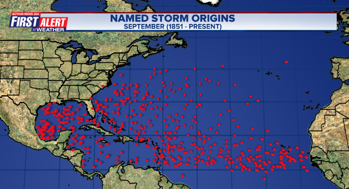
July tropical cyclone origins:
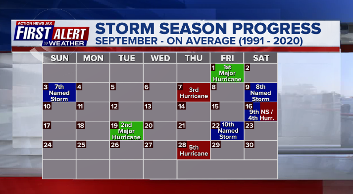
Averages below based on climatology for the Atlantic Basin for August:
Wind shear:


Saharan dust spreads west each year from Africa by the prevailing winds (from east to west over the Atlantic). Dry air - yellow/orange/red/pink. Widespread dust is indicative of dry air that can impede the development of tropical cyclones. However, sometimes “wanna’ be” waves will just wait until they get to the other side of - or away from - the plume then try to develop if other conditions are favorable. In my personal opinion, way too much is made about the presence of Saharan dust & how it relates to tropical cyclones. In any case, the peak of Saharan dust typically is in June & July.

2023 names..... “Nigel” is the next name on the Atlantic list (names are picked at random by the World Meteorological Organization... repeat every 6 years). Historic storms are retired [Florence & Michael in ’18... Dorian in ’19 & Laura, Eta & Iota in ‘20, Ida in ‘21 & Fiona & Ian in ‘22]). In fact, this year’s list of names is rather infamous with “Katrina”, “Rita” & “Wilma” retired from the ‘05 list & “Harvey”, “Irma”,“Maria” & “Nate” from the ‘17 list. The WMO decided - beginning in 2021 - that the Greek alphabet will be no longer used & instead there will be a supplemental list of names if the first list is exhausted (has only happened three times - 2005, 2020 & 2021). The naming of tropical cyclones began on a consistent basis in 1953. More on the history of naming tropical cyclones * here *.

East Atlantic:


Mid & upper level wind shear (enemy of tropical cyclones) analysis (CIMMS). The red lines indicate strong shear:

Water vapor imagery (dark blue indicates dry air):

Deep oceanic heat content over the Gulf, Caribbean & deep tropical Atlantic. The brighter colors are expanding dramatically as we near the peak of the hurricane season.:

Sea surface temp. anomalies:


SE U.S. surface map:

Surface analysis centered on the tropical Atlantic:

Surface analysis of the Gulf:

Caribbean:

Atlantic Basin wave period forecast for 24, 48, 72 & 96 hours respectively:


East/Central Pacific:


West Pacific:

Global tropical activity:


Cox Media Group
:quality(70)/cloudfront-us-east-1.images.arcpublishing.com/cmg/YFVQFPSEYFGUJNN5FIL45PWXNM.jpg)
:quality(70)/cloudfront-us-east-1.images.arcpublishing.com/cmg/OP4L4IUHEIWRTTX257DKOM4IMU.jpg)
:quality(70)/cloudfront-us-east-1.images.arcpublishing.com/cmg/GUKNEPXKO4TU3TGUXRFOFQBQLY.jpg)
:quality(70)/cloudfront-us-east-1.images.arcpublishing.com/cmg/M7DQOP5FJNTRMVP5QYWYEBACAI.jpg)
:quality(70)/d1hfln2sfez66z.cloudfront.net/07-24-2024/t_438ef8fe0328479ab8ba5ce2c553b6b6_name_file_960x540_1200_v3_1_.jpg)