:quality(70)/cloudfront-us-east-1.images.arcpublishing.com/cmg/WW5AJL3ARQUGDQMAQUNSFX4CLE.jpg)
Jacksonville, Fl. — The “Buresh Bottom Line”: Always be prepared!.....First Alert Hurricane Survival Guide... City of Jacksonville Preparedness Guide... Georgia Hurricane Guide.
STAY INFORMED: Get the * FREE * First Alert Weather app
FREE NEWS UPDATES, ALERTS: Action News Jax app for Apple | For Android
WATCH “Talking & Tracking the Tropics: The Science Behind the Season”
WATCH “Preparing for the Storm”
READ the First Alert Hurricane Center “Survival Guide”
***** ALWAYS CHECK & RE-CHECK THE LATEST FORECAST & UPDATES! *****
TROPICS:
(1) Tropical depression #17 formed over the Eastern Atlantic Sunday & was upgraded to tropical storm “Paulette” Mon. The fastest ever to ’P’ easily beating the old record of Philippe Sept. 17, 2005. The large system will move steadily - but rather slowly - to the west/northwest over the open Atlantic this week into the weekend. Paulette should gain enough latitude - by the weekend/early next week to end up being a recurve to the north & northeast. The exact timing of the northward move is still up in the air & will be highly dependent on how strong the tropical cyclone is in the longer term. Paulette will battle some dry air & occasional shear for a good part of the rest of this week.
(2) Tropical depression #18 was upgraded just off the coast of Africa early Mon. then to tropical storm “Rene” Mon. afternoon before a weakening trend Tue. night. Rene will turn more northward late this week over the Eastern then Central Atlantic & should go through a re-strengthening phase. There may eventually be some interaction with tropical storm Paulette to Rene’s west, but it seems clear that Rene will stay far to the east.
(3) A long track tropical wave well southwest of Bermuda & several hundred miles east/northeast of Jacksonville is over the Western Atlantic and has developed a small, disorganized surface low pressure system. Showers & t’storms have increased over the eastern portion of the circulation & some slight development is possible - perhaps even a tropical depression - but there’s no indication - thanks to increasing shear to the west - this will become a significant storm while moving west/northwest well northeast of Jacksonville Wed. & into the Carolina’s Thu./Fri. There will be an increase in rain for the coastal Carolina’s but major impacts are not expected at this time.

(4) Another in a series of active tropical waves will roll off Africa in the coming days. This one looks to move west at a lower latitude riding a narrow ridge on the underside of the the two tropical cyclones (Paulette/Rene) to the north. This wave may be something to keep a close eye on next week as it could be nearing parts of the Caribbean mid to late week.
(5) A lowering of pressures has been indicated by forecast models over the Western Gulf of Mexico by the weekend into next week. Low pressure may eventually develop. If so, it’s an area to keep an eye on for possible tropical development.


Positioning of the upper level ridge this week is quite far to the north over the Atlantic so the movement of tropical “activity” is slower than past weeks. There should be enough of a weakness for the first two systems to turn more northward in time but the ridge is expected to strengthen thereafter which could push system #3 more to the south & west implying a higher risk of land interaction..... eventually.


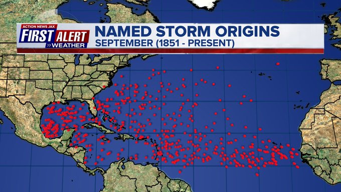
September is usually the most active month of the hurricane season:


:quality(70)/cloudfront-us-east-1.images.arcpublishing.com/cmg/DV6J4GIEWRE2ARNHRJWBBTSFMU.jpg)
:quality(70)/cloudfront-us-east-1.images.arcpublishing.com/cmg/SPL6W4EORNAJDGIBFCNGGKDLLU.png)
:quality(70)/d1hfln2sfez66z.cloudfront.net/04-28-2024/t_c7204efb6774424b8fc4cd0b9d066d68_name_file_960x540_1200_v3_1_.jpg)
:quality(70)/cloudfront-us-east-1.images.arcpublishing.com/cmg/IU3KKPPAS5HBVKUDNMVXJPK2MM.jpg)
:quality(70)/d1hfln2sfez66z.cloudfront.net/04-28-2024/t_de6cc1c2423f4e3c983161d8ecf28547_name_file_960x540_1200_v3_1_.jpg)