:quality(70)/cloudfront-us-east-1.images.arcpublishing.com/cmg/WW5AJL3ARQUGDQMAQUNSFX4CLE.jpg)
Jacksonville, Fl. — The “Buresh Bottom Line”: Always be prepared!.....First Alert Hurricane Survival Guide... City of Jacksonville Preparedness Guide... Georgia Hurricane Guide.
STAY INFORMED: Get the * FREE * First Alert Weather app
FREE NEWS UPDATES, ALERTS: Action News Jax app for Apple | For Android
WATCH “Talking & Tracking the Tropics: The Science Behind the Season”
WATCH “Preparing for the Storm”
READ the First Alert Hurricane Center “Survival Guide”
***** ALWAYS CHECK & RE-CHECK THE LATEST FORECAST & UPDATES! *****
LOCAL - JAX/NE FL./SE GA. impacts from current tropical activity: ** None of consequence ** ... but folks traveling or who live anywhere along the Gulf Coast from Florida’s Panhandle to Texas - need to stay up to date on future forecasts regarding the tropics as fast changes/development will be possible into next week.
Any local impacts from tropical storm Laura look to be relegated to a slight bump in waves & surf through early next week & a bit of a surge of tropical moisture from the east increasing rain slightly. No significant direct local impacts are anticipated while current tropical cyclones take the “low road” - Marco far to the west & Laura well to the south then well to the west.
According to Phil Klotzbach, “hurricane guru” @ CSU, this will be only the 3rd time since 1851 that there have been simultaneous Gulf of Mexico storms with winds 39+ mph (tropical storm strength): Sept. 5, 1933 & June 18, 1959 (especially impressive - early season!).
LAURA:
Laura will likely be the true “problem child” as the storm will have plenty of warm water to cross under favorable (atmospheric) conditions to strengthen in the coming days before reaching the Gulf Coast mid to late week. Models have been trending west recently & Texas may end being landfall though it’s still early on how steering currents will exactly play out.
Strong tropical wave ’98-L’ was upgraded to tropical depression #13 Wed. then to tropical storm “Laura” Fri. while steadily moving west & across or near Puerto Rico, Hispaniola & Cuba. This is the fastest to the 12th storm breaking the record of “Luis” on Aug. 29, 1995. As the Bermuda High to the north expands & strengthens, Laura should continue a steady track west before a slow bend to the northwest & forecast models are in excellent agreement on such. This pushes the cyclone away from Puerto Rico to near Hispaniola Sunday... & near or over Cuba late Sunday into Monday. There remains a reasonable chance - as has been the case in recent days - for a track farther south & west as the Bermuda High flexes its muscles. There has been - & will be - a good deal of land interaction which will limit much strengthening through Monday & probably cause some weakening or at least disorganization. Satellite & radar data, however, still a relatively impressive cyclone with an increase in the upper level outflow, especially considering all the land interaction over the last several days. The center may very well jump around some until the cyclone is away from land. Given the appearance on satellite & the presence of good upper level outflow, Laura may fairly quickly strengthen once over the Gulf of Mexico.
As has been the case since its inception, I’m still concerned about a “late bloomer” on this one. A tropical cyclone that’s relatively weak until making it into or near the Gulf of Mexico by Tuesday. Once in the Gulf & away from any land areas, there should be a gradual turn more northward. There will be heavy squalls into Monday for Cuba with a distinct threat for flash flooding & landslides. As Marco approaches the Gulf Coast Monday & quickly weakens, it looks like the alleyway to the Gulf opened up by a departing/weakening upper level trough will pretty quickly close as an extension of the sprawling Atlantic Bermuda High builds to the west. This turn of events may be why forecast models have recently trended west in what could be a major hurricane threatening Texas &/or Louisiana by late week.
MARCO:
Tropical wave ’97-L’ has turned rather sharply to the north after entering the Caribbean Mon. night & has been upgraded - as of Thu. morning - to tropical depression #14 & then to tropical storm “Marco” Fri. evening & briefly to a hurricane Sunday afternoon before being downgraded again. Marco - compact tropical cyclone - has been slowing some & turning more northward as it gets to the western edge of the now sprawling Bermuda High over the Atlantic & is following a weakness in the flow helped out by an upper level trough. Marco missed most of the potential land interaction with the Yucatan Peninsula which allowed for short term strengthening though shear out of the SW is strong (25+ mph) & should keep Marco “in check” overall. While looking rather “healthy” Thu., Marco became pretty disheveled Thu. night only to see bursts of convection Fri./Fri. evening that have continued since. There has been - & will continue to be - a tendency for most of the heavy rain & wind to be over the north & east quadrant due to the persistent shear. As the Bermuda High builds to the west & Marco weakens, the storm should turn more to the west with time.
In any case.... at least a tropical storm will threaten the Central Gulf of Mexico by Monday into Tue. centered on Louisiana. The heavy rain may set the table for more extensive flooding later in the week with the approach of Laura.
There has been quite a bit of scuttlebutt regarding a possible “Fujiwhara effect” between Marco & Laura. Right now I see the two systems as remaining their own separate entities, so I’m not going there. Eventually there could be some outflow interaction depending on where the systems are & how strong they are (tropical cyclone Fujiwhara effects have happened in the past, by the way). But no need for a lot of hype(!) or concern on this possibility.
Overall conditions across the Atlantic Basin appear “ready to go” as we head into late Aug. & early Sept. (see velocity potential anomalies map below). I’m also tracking a long track tropical disturbance soon to move westward across the Atlantic that could threaten some part of the U.S. between ~Sept. 1 & Sept. 9th.


Lots of spaghetti(!):


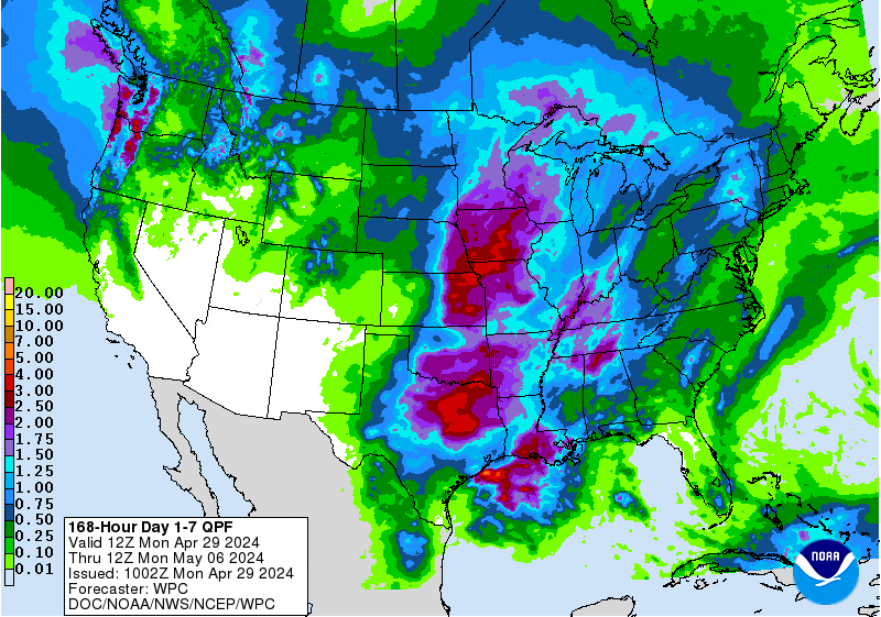
Lots of rain along & near the Gulf Coast into next week due to a combination of tropical activity & an upper level trough with extreme rainfall possible from the upper Texas coast to the far Western Fl. Panhandle:
A change of phase of the MJO (Madden-Julian oscillation) should help lead to an uptick in Atlantic tropical cyclones late this month into September. The upper level “velocity potential anomalies” map below shows “upward motion” - green lines - spreading east from the already active E. Pacific. Such a pattern often correlates to an increase in tropical systems that would eventually include the Atlantic Basin.


A strong tropical wave over the Eastern Atlantic is marching west. Forecast models are not jumping on this one yet but something to keep an eye on....


:quality(70)/cloudfront-us-east-1.images.arcpublishing.com/cmg/YNYHQR4LBVFI3OJGCFF32OEDVM.png)
:quality(70)/cloudfront-us-east-1.images.arcpublishing.com/cmg/WTTCCYMCX5CHJL3NG4LVJGHE4Q.jpg)
:quality(70)/cloudfront-us-east-1.images.arcpublishing.com/cmg/HX2U3Y45JBCXXA7M6YH3A3B6AQ.jpg)
:quality(70)/cloudfront-us-east-1.images.arcpublishing.com/cmg/VAM4IBO2KVGI7GDIPZEILKRCM4.jpg)
:quality(70)/cloudfront-us-east-1.images.arcpublishing.com/cmg/WO6FUFMDKC7TQHGZ6HTHMKKGSY.jpg)