
Jacksonville, Fl. — The “Buresh Bottom Line”: Always be prepared!.....First Alert Hurricane Survival Guide... City of Jacksonville Preparedness Guide... Georgia Hurricane Guide.
STAY INFORMED: Get the * FREE * First Alert Weather app
FREE NEWS UPDATES, ALERTS: Action News Jax app for Apple | For Android
WATCH “Preparing for the Storm”
WATCH “The Ins & Outs of Hurricane Season”
READ the First Alert Hurricane Center “Survival Guide”
LISTEN & WATCH “Surviving the Storm” - WOKV Radio & Action News Jax
***** ALWAYS CHECK & RE-CHECK THE LATEST FORECAST & UPDATES! *****
REMEMBER WHEN A TROPICAL STORM OR HURRICANE IS APPROACHING: Taping windows is *NOT* helpful & will not keep glass from breaking.
Realize the forecast cone (”cone of uncertainty”) is the average forecast error over a given time - out to 5 days - & *does not* indicate the width of the storm &/or damage that might occur.

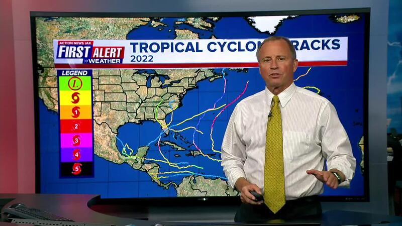
The 2022 Atlantic hurricane season is history. And in the end - it was “average” - at least on the surface & purely by the numbers. But, of course, the devil is in the details & those details will insure the ‘22 hurricane season is long remembered.
A video recap:
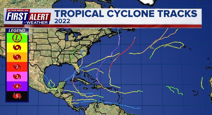
Florida will remember mighty & powerful hurricane Ian in late Sept... & late season Cat. 1 Nicole in early to mid Nov. And South Florida endured flooding from a disturbance that eventually became Alex to the east of Florida the first week of the hurricane season in early June.

So we add another “major” hurricane landfall to the list of Florida tropical cyclones. Cat. 4 Ian, Ft. Myers:

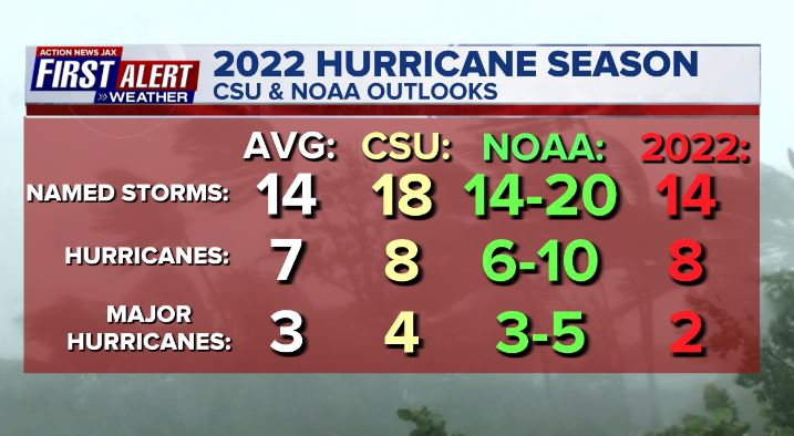
Avg. Atlantic hurricane season vs. the CSU (Dr. Klotzbach) & NOAA seasonal forecasts vs. the ‘22 reality:


Month by Month:
JUNE - After dumping heavy rain on South Florida, a disturbance was upgraded to tropical storm “Alex” once to the east of Florida & was declared dissipated one day later.
JULY - 1st: Tropical storm “Bonnie” formed over the Western Caribbean & hit Nicaragua & Costa Rica before crossing into the far Eastern Pacific until finally dissipating July 9th.
2nd: Tropical storm “Colin” was christened as the storm exited North Carolina & moved over the Western Atlantic dissipating just one day later.
AUGUST - No named storms which has occurred - in the satellite era - only one other August - 1997.
SEPTEMBER - 1st: “Danielle” forms over the N. Atlantic & becomes the first hurricane of the season the next day.
2nd: Tropical storm “Earl” forms over the N. Atlantic
14th: Tropical storm “Fiona” forms over the Central Atlantic then hits Puerto Rico as a Cat. 1 hurricane. Fiona went on to become one of two “major” hurricanes for the season while over the Western Atlantic.
20th: Tropical storm “Gaston” forms over the Central Atlantic
23rd: Tropical storm Ian - which would become the “poster child” for the ‘22 season - forms over the Central Caribbean... tropical depression #10 forms over the E. Atlantic & become tropical storm “Hermine” a few hours later.
27th: Cat. 3 hurricane Ian hits Western Cuba & reaches the Dry Tortugas early the next morning
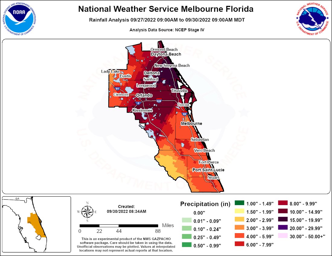
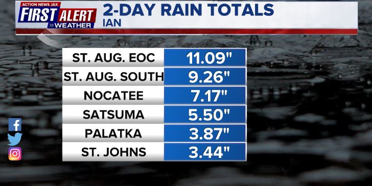
28th: Cat. 4 Ian late afternoon landfall near Fort Myers with the most significant impacts for NE Fl./SE Ga. - mainly east of I-95 to the beaches - the next day on Sept. 29th including heavy rain & storm surge. See the “Buresh Blog” & “Infamous Ian - a Blow by Blow”.... Also on the 28th - and tropical depression #11 forms over the East Atlantic
30th: Ian 3rd & final landfall at Georgetown, SC as a Cat. 1.

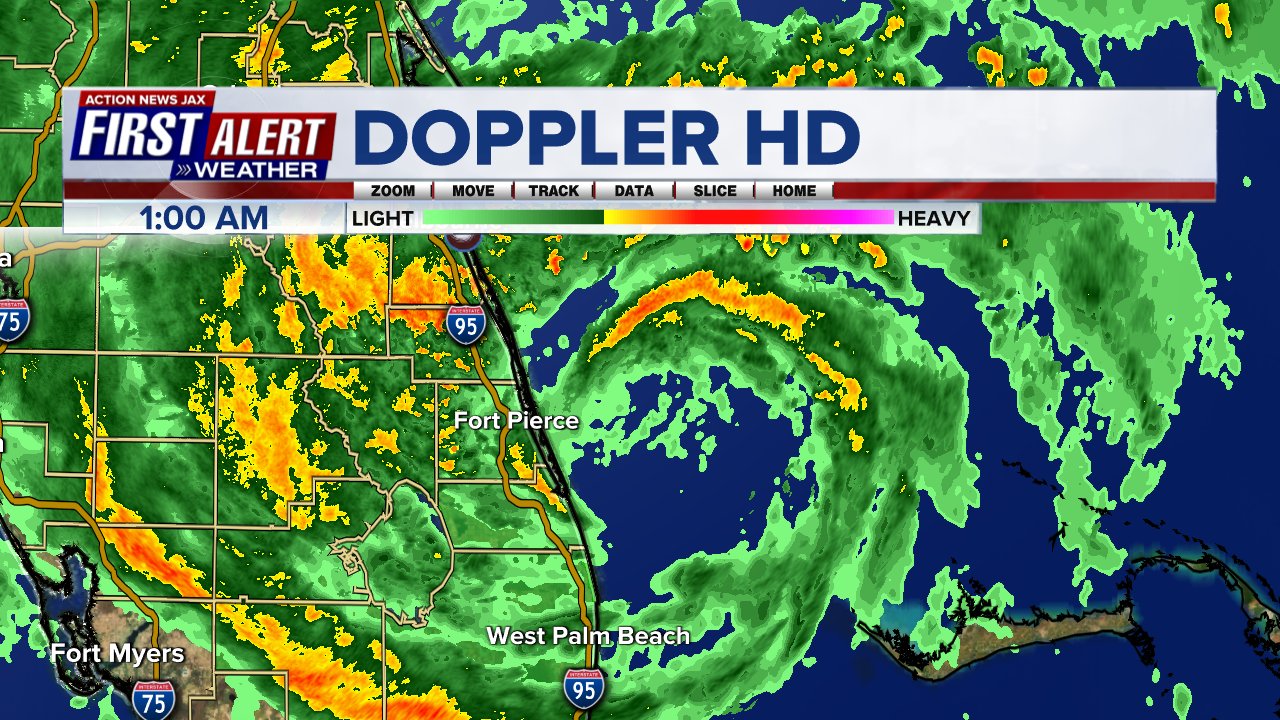
Ian’s eye directly over the Dry Tortugas late in the evening, Sept. 27th:

Extreme rainfall accompanied Ian across Central to East Central Fl. helping to cause days & weeks of flooding:

#firstalertwx check out the storm surge flooding time lapse in St. Augustine Thu., 09/29 from #Ian @ActionNewsJax @WOKVNews @wmvisionks pic.twitter.com/o3OoAhmArL
— Mike Buresh (@MikeFirstAlert) September 30, 2022

OCTOBER - 4th: tropical depression #12 forms over the E. Atlantic
6th: Tropical depression #13 forms over the Southern Caribbean... becomes tropical storm “Julia” on the 7th... & hits the coast of Nicaragua on the 9th as a Cat. 1 hurricane.
11th: Tropical storm “Karl” forms over the Bay of Campeche
31st: Tropical storm “Lisa” forms over the Central Caribbean
NOVEMBER - 1st: Tropical storm Martin forms over the N. Atlantic
2nd: Cat. 1 hurricane Lisa hits Central America at Belize City (only the 3rd time in modern history with 2 hurricanes [Lisa & Martin] over the Atlantic Basin at the same time in Nov.)
7th: Subtropical storm “Nicole” develops over the Central Atlantic
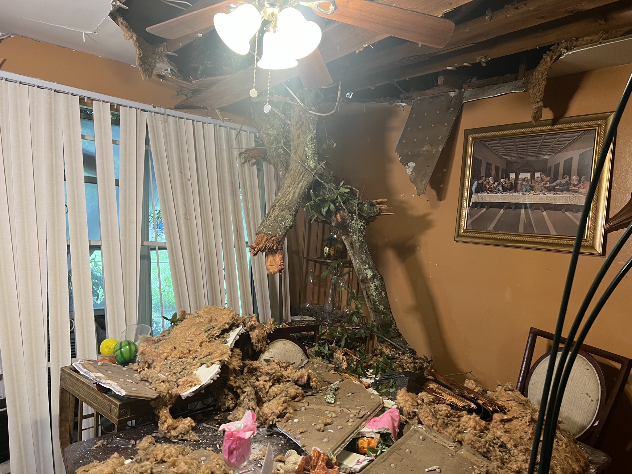
10th: Cat. 1 hurricane Nicole landfall near Vero Beach, FL about 3am EDT. It’s the latest landfalling hurricane on record for the U.S. east coast & the 2nd latest U.S. hurricane landfall on record (Cat. 2 Kate Nov. 22, 1985) Heavy rain, flooding & severe beach erosion occurred across NE Fl. & SE Ga. See the “Buresh Blog” - “The Late Season Nemesis that was Nicole”.

Nicole just before Florida’s landfall on First Alert Doppler HD:
Oceanway (Northside, Jacksonville) wind damage:
Vilano Beach erosion:

NE Fl./SE Ga. Nicole rainfall:


NOAA satellite review of the ‘22 season:
The ACE (Accumulated Cyclone Energy) - is a metric to express the energy released by a tropical cyclone during its lifetime. It is calculated by summing the square of a tropical cyclone’s maximum sustained winds, measured every six hours. *Every* global basin was below avg. through Nov. 29:

Cox Media Group


