:quality(70)/cloudfront-us-east-1.images.arcpublishing.com/cmg/WW5AJL3ARQUGDQMAQUNSFX4CLE.jpg)
Jacksonville, Fl. — The “Buresh Bottom Line”: Always be prepared!.....First Alert Hurricane Survival Guide... City of Jacksonville Preparedness Guide... Georgia Hurricane Guide.
STAY INFORMED: Get the * FREE * First Alert Weather app
FREE NEWS UPDATES, ALERTS: Action News Jax app for Apple | For Android
WATCH “Talking & Tracking the Tropics: The Science Behind the Season”
WATCH “Preparing for the Storm”
READ the First Alert Hurricane Center “Survival Guide”
***** ALWAYS CHECK & RE-CHECK THE LATEST FORECAST & UPDATES! *****
Tropical wave - ‘95-L’ was upgraded to tropical depression #11 Tue. while moving from the East into the Central Atlantic. The short term environment appears conducive enough for strengthening into a tropical storm (Josephine) before reaching a more hostile environment over/near the SW Atlantic. A stronger/deeper system would favor a quicker turn northwest then north & likely well to the east of the U.S. thanks to a break in the Bermuda high that will exist through the weekend. However, the Bermuda high will begin to expand some next week, so we do need to be vigilant of its alleyway out over the open Atlantic becoming blocked.
A weaker system, on the other hand, would likely end up farther west steered more by the low level trade winds. More west is not necessarily a problem since we would have a weak system if not just a tropical wave. Compact t.d. #11 is within a dry mid & upper level air mass & moderate shear. This combination should generally limit how strong the tropical cyclone becomes.
Subsequent tropical waves may end up being the most problematic as the waves continue to roll off of Africa into a more favorable set-up for tropical development later in the month.
It will also be worth keeping an eye on the Gulf of Mexico next week as an upper level trough develops/evolves near the Gulf Coast then nudges/builds southward into the Gulf of Mexico. While not yet indicated by forecast models, this trough could induce surface low pressure over/near the Gulf that could then gradually become tropical.
And there will be a series of surface low pressure systems that move east/northeast from the U.S. east coast across the NW Atlantic. There might be occasional attempts at tropical development but the systems will be moving away from the U.S. deeper into the Atlantic.
Overall conditions across the Atlantic Basin appear “ready to go” as we head into mid to late Aug. - particularly the 20th-31st then on into Sept.


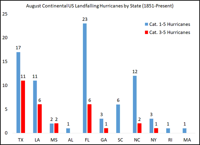
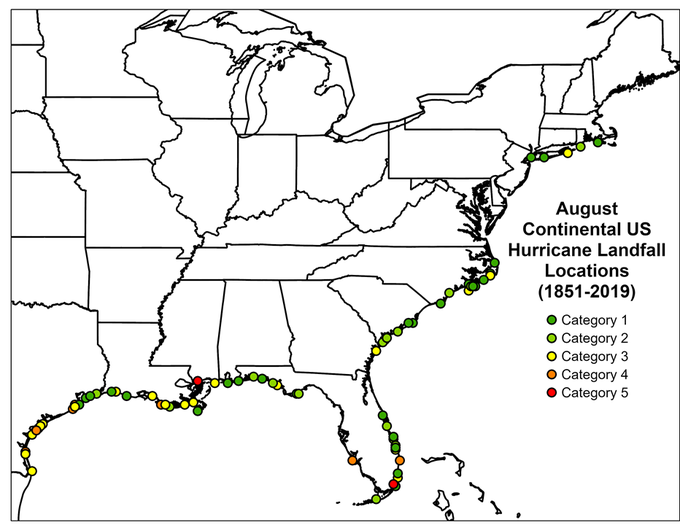
The graph & map below - the next 2 images - courtesy Dr. Phil Klotzbach showing Aug. landfalling hurricanes:
A change of phase of the MJO (Madden-Julian oscillation) should help lead to an uptick in Atlantic tropical cyclones late this month into September. The upper level “velocity potential anomalies” map below shows “upward motion” - green lines - spreading east from the already active E. Pacific. Such a pattern often correlates to an increase in tropical systems.


:quality(70)/cloudfront-us-east-1.images.arcpublishing.com/cmg/AMZKHO2QTJBXFGQZBMJU3BNBCE.jpg)
:quality(70)/cloudfront-us-east-1.images.arcpublishing.com/cmg/N5HQUG7UUZC5NO7LV2U6JCNF7E.jpg)
:quality(70)/cloudfront-us-east-1.images.arcpublishing.com/cmg/2J5VPZFH4VCVRCZYREA76XCB7M.jpg)
:quality(70)/d1hfln2sfez66z.cloudfront.net/05-15-2024/t_f9f71711bba4468ea3e2aa50436466b4_name_file_960x540_1200_v3_1_.jpg)
:quality(70)/cloudfront-us-east-1.images.arcpublishing.com/cmg/2CP356OBSBFRLNGWQCSM5QBVDA.jpeg)