
Jacksonville, Fl. — The “Buresh Bottom Line”: Always be prepared!.....First Alert Hurricane Preparation Guide... City of Jacksonville Preparedness Guide... Georgia Hurricane Guide.
STAY INFORMED: Get the * FREE * First Alert Weather app
FREE NEWS UPDATES, ALERTS: Action News Jax app for Apple | For Android
WATCH “Preparing for the Storm”
WATCH “The Ins & Outs of Hurricane Season”
READ the First Alert Hurricane Center “Survival Guide”
LISTEN & WATCH “Surviving the Storm” - WOKV Radio & Action News Jax
***** ALWAYS CHECK & RE-CHECK THE LATEST FORECAST & UPDATES! *****
REMEMBER WHEN A TROPICAL STORM OR HURRICANE IS APPROACHING: Taping windows is *not* recommended & will not keep glass from breaking. Instead close curtains & blinds.
Realize the forecast cone (”cone of uncertainty”) is the average forecast error over a given time - out to 5 days - & *does not* indicate the width of the storm &/or where damage that might occur.

*** LOCAL (Jacksonville/NE Fl./SE Ga.) IMPACTS FROM THE TROPICS: None.
The Atlantic Basin Overview:
** Tammy is near the Lesser Antilles...
** A couple of tropical waves are over the Central & Eastern Atlantic & moving west/northwest.
** Weak low pressure may develop over the Southwest Caribbean then move inland over Central America

A tropical wave/low pressure area - ‘94-L’ - was upgraded to tropical storm “Tammy” late Wed. & to a hurricane Fri. morning. Forecast models continue to come into better agreement on Tammy turning sharply northward but not before impacting the Northern Lesser Antilles through Saturday with heavy rain & strong winds. It still looks like the core of Tammy stays east of Puerto Rico resulting in mostly minor impacts for the island.
The path beyond the Caribbean remains complicated with various solutions amongst the forecast models including a good deal of run to run variability within themselves. There is an increasing probability that Tammy may be left behind by the upper level trough that will move across the N. Atlantic. If so, then Tammy could languish over the Southwest Atlantic north of the Caribbean for a number of days.
A Hurricane WARNING: Guadeloupe ... Antigua, Barbuda, Montserrat, St. Kitts, Nevis, and Anguilla ... St. Maarten ... St. Martin and St. Barthelemy. A Hurricane WATCH: Dominica ... Saba and St. Eustatius. A Tropical Storm WARNING: Dominica ... Saba and St. Eustatius. A Tropical Storm WATCH: Martinique ... British Virgin Islands.


Additional spaghetti plots for Tammy:


The upper oceanic heat content (UOHC) [tropical cyclone heat potential/TCHP] across the SW Atlantic, Gulf & Caribbean:


Water vapor loop (dark blue/yellow is dry mid & upper level air):


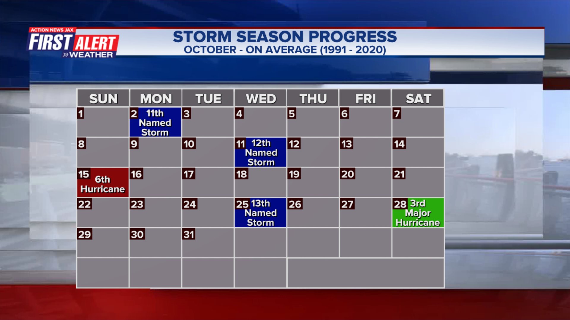
October tropical cyclone origins:

Averages below based on climatology for the Atlantic Basin for October:
Wind shear:


Saharan dust spreads west each year from Africa by the prevailing winds (from east to west over the Atlantic). Dry air - yellow/orange/red/pink. Widespread dust is indicative of dry air that can impede the development of tropical cyclones. However, sometimes “wanna’ be” waves will just wait until they get to the other side of - or away from - the plume then try to develop if other conditions are favorable. In my personal opinion, way too much is made about the presence of Saharan dust & how it relates to tropical cyclones. In any case, the peak of Saharan dust typically is in June & July.

2023 names..... “Vince” is the next name on the Atlantic list (names are picked at random by the World Meteorological Organization... repeat every 6 years). Historic storms are retired [Florence & Michael in ’18... Dorian in ’19 & Laura, Eta & Iota in ‘20, Ida in ‘21 & Fiona & Ian in ‘22]). In fact, this year’s list of names is rather infamous with “Katrina”, “Rita” & “Wilma” retired from the ‘05 list & “Harvey”, “Irma”,“Maria” & “Nate” from the ‘17 list. The WMO decided - beginning in 2021 - that the Greek alphabet will be no longer used & instead there will be a supplemental list of names if the first list is exhausted (has only happened three times - 2005, 2020 & 2021). The naming of tropical cyclones began on a consistent basis in 1953. More on the history of naming tropical cyclones * here *.


East Atlantic:


Mid & upper level wind shear (enemy of tropical cyclones) analysis (CIMMS). The red lines indicate strong shear:

Water vapor imagery (dark blue indicates dry air):

Deep oceanic heat content over the Gulf, Caribbean & deep tropical Atlantic. The brighter colors are expanding dramatically as we near the peak of the hurricane season.:

Sea surface temp. anomalies:


SE U.S. surface map:

Surface analysis centered on the tropical Atlantic:

Surface analysis of the Gulf:

Caribbean:

Atlantic Basin wave period forecast for 24, 48, 72 & 96 hours respectively:


East/Central Pacific:
Hurricane “Norma” will impact parts of the Baja of California through the weekend then the upper west coast of Mexico while weakening early in the week.
A Hurricane WARNING: Baja California Sur from Todos Santos to Los Barriles. A Tropical Storm WARNING: North of Los Barriles to San Evaristo ... North of Todos Santos to Santa Fe ... Topolobampo to Mazatlan. A Tropical Storm WATCH: Las Islas Marias.


West Pacific:
Tropical cyclone “Jej” headed for the upper east coast of Yemen early in the week:


Global tropical activity:


Cox Media Group


