:quality(70)/cloudfront-us-east-1.images.arcpublishing.com/cmg/WW5AJL3ARQUGDQMAQUNSFX4CLE.jpg)
Jacksonville, Fl. — The “Buresh Bottom Line”: Always be prepared!.....First Alert Hurricane Survival Guide... City of Jacksonville Preparedness Guide... Georgia Hurricane Guide.
STAY INFORMED: Get the * FREE * First Alert Weather app
FREE NEWS UPDATES, ALERTS: Action News Jax app for Apple | For Android
WATCH “Talking & Tracking the Tropics: The Science Behind the Season”
WATCH “Preparing for the Storm”
READ the First Alert Hurricane Center “Survival Guide”
***** ALWAYS CHECK & RE-CHECK THE LATEST FORECAST & UPDATES! *****
LOCAL - JAX/NE FL./SE GA. impacts through this weekend: ** None ** ... we - anywhere along the Gulf Coast &/or Fl. - need to stay up to date on future forecasts regarding the tropics as fast changes/development will be possible into next week.
Any local impacts from tropical storm Laura look to be relegated to a slight bump in waves & surf early next week & a bit of a surge of tropical moisture from the east increasing rain slightly. No significant local impacts are anticipated while t.d. #14 stays far to the west with no impacts at all.
Strong tropical wave ’98-L’ was upgraded to tropical depression #13 Wed. then to tropical storm “Laura” Fri. while steadily moving west & approaching the NE Caribbean. This is the fastest to the 12th storm breaking the record of “Luis” on Aug. 29, 1995. As the Bermuda High to the north expands & strengthens, Laura should continue a steady track west before a slow bend to the northwest & forecast models are in excellent agreement on such. This puts the system near Puerto Rico Sat. ... near Hispaniola Sat. night... & near or even over Cuba Sunday into Monday. There remains a reasonable chance - as has been the case in recent days - for a track farther south as the Bermuda High flexes its muscles. There is also an argument for a more southern route (more westward movement) if the tropical cyclone remains weak. Land interaction looks to be more of a factor leading to likely disruptions in its organization resulting in complications with the overall forecast - both track & especially intensity.
Intensity continues to be a difficult forecast which is not unusual but even more so in the case of Laura. Several of the typically more reliable models - the European & GFS, for example - show little strengthening... & even weakening in some forecast cycles. The UKMET is generally stronger but not as intense as past model runs & has trended south & west. I’m still concerned about a “late bloomer” on this one. A tropical cyclone that’s quite weak possibly until making it into or near the Gulf of Mexico next week. Once in the Gulf (or far Northern Caribbean) & away from any land areas, there should be a gradual turn more northward. It looks like there will be some heavy squalls this weekend for parts of the Northern Lesser Antilles as well as Puerto Rico, Hispaniola & eventually Cuba through the weekend. In addition to land interaction, there is some dry air & a fair amount of shear in the path of Laura which could serve to limit intensification, especially in the shorter term.
The low & mid level centers of Laura have not been in sync with the mid level center generally far removed from the low level circulation which actually has been multiple swirls. Until & unless those centers become aligned, strengthening will be limited.
Tropical wave ’97-L’ has continued west after entering the Caribbean Mon. night & has been upgraded - as of Thu. morning - to tropical depression #14. TD #14 has been slowing some as it gets to the western edge of the now sprawling Bermuda High over the Atlantic & this is where we’ll have to pay close attention. While looking rather “healthy” Thu., the depression became rather disheveled overnight. It does look like there will be a landfall near/over Central America/Yucatan this weekend which will cause at least some weakening or a pause in any strengthening. From there, td #14 should turn more northward re-emerging over the Western Gulf of Mexico late in the weekend/ early next week. Depending on how fast the system can reorganize, at least a tropical storm may then threaten Mexico or Texas - possibly even as far east as Louisiana - by the middle or end of next week.
An upper level trough of low pressure has built southward over the Gulf coast states & Gulf of Mexico & will be lifting northward over the weekend. Once this feature leaves the area, it appears there will be some room for the Bermuda High - or an extension of the upper high - to build into the area. How exactly this plays out will probably have at least some role in how tropical systems are steered - & where they eventually go - next week. Forecast models remain relatively tame with the intensity of both systems throughout most model runs though there will be windows of “opportunity” ahead for significant intensification if all things come together.
There has been quite a bit of scuttlebutt regarding a possible “Fujiwhara effect” between t.d. #14 & Laura. Right now I see the two systems as remaining their own separate entities, so I’m not going there. Eventually there could be some outflow interaction next week depending on where the systems are & how strong they are. (Tropical cyclone Fujiwhara effects have happened in the past, by the way)
Overall conditions across the Atlantic Basin appear “ready to go” as we head into late Aug. & early Sept. (see velocity potential anomalies map below).


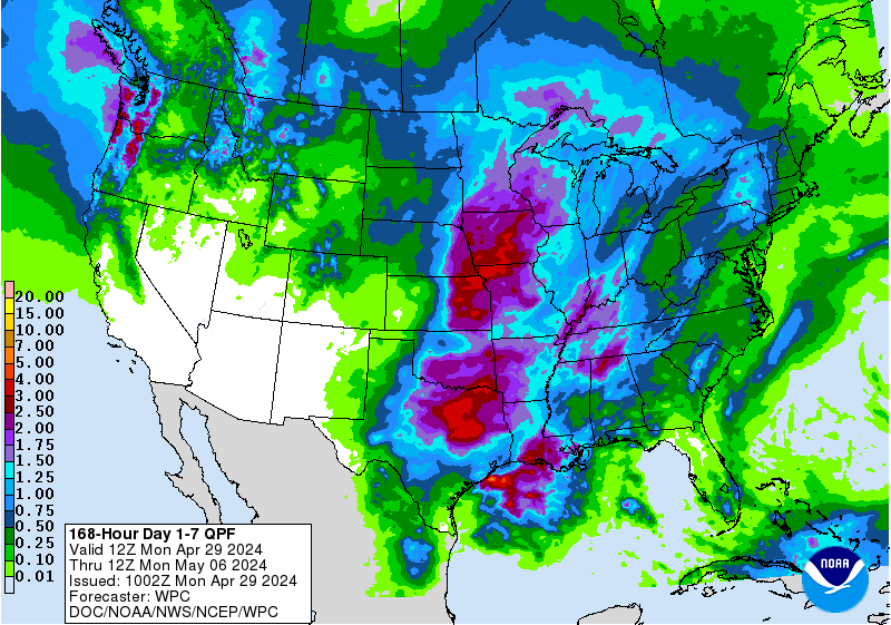
Lots of rain along & near the Gulf Coast into next week due to a combination of tropical activity & an upper level trough:

A change of phase of the MJO (Madden-Julian oscillation) should help lead to an uptick in Atlantic tropical cyclones late this month into September. The upper level “velocity potential anomalies” map below shows “upward motion” - green lines - spreading east from the already active E. Pacific. Such a pattern often correlates to an increase in tropical systems that would eventually include the Atlantic Basin.


:quality(70)/cloudfront-us-east-1.images.arcpublishing.com/cmg/2A2742EUVFCDRJBTDWWG5EQ36E.jpeg)
:quality(70)/cloudfront-us-east-1.images.arcpublishing.com/cmg/YNYHQR4LBVFI3OJGCFF32OEDVM.png)
:quality(70)/cloudfront-us-east-1.images.arcpublishing.com/cmg/OOUFYBT7MBHC5C2CK7SMG6D35I.jpg)
:quality(70)/cloudfront-us-east-1.images.arcpublishing.com/cmg/F2HDNUPNINBJVMOJF6EVE2VRMI.png)
:quality(70)/cloudfront-us-east-1.images.arcpublishing.com/cmg/HX2U3Y45JBCXXA7M6YH3A3B6AQ.jpg)