:quality(70)/cloudfront-us-east-1.images.arcpublishing.com/cmg/WW5AJL3ARQUGDQMAQUNSFX4CLE.jpg)
Jacksonville, Fl. — The “Buresh Bottom Line”: Always be prepared!.....First Alert Hurricane Survival Guide... City of Jacksonville Preparedness Guide... Georgia Hurricane Guide.
STAY INFORMED: Get the * FREE * First Alert Weather app
FREE NEWS UPDATES, ALERTS: Action News Jax app for Apple | For Android
WATCH “Preparing for the Storm”
WATCH “The Ins & Outs of Hurricane Season”
READ the First Alert Hurricane Center “Survival Guide”
LISTEN & WATCH “Surviving the Storm” - WOKV Radio & Action News Jax
***** ALWAYS CHECK & RE-CHECK THE LATEST FORECAST & UPDATES! *****
REMEMBER WHEN A TROPICAL STORM OR HURRICANE IS APPROACHING: Taping windows is *NOT* helpful & will not keep glass from breaking.
Realize the forecast cone (”cone of uncertainty”) is the average forecast error over a given time - out to 5 days - & *does not* indicate the width of the storm &/or damage that might occur.

Tropical storm WARNING for parts of Central & South Florida, Bahamas & parts of Cuba .....
*For Jacksonville/NE Fl./SE Ga.* based on the *current* forecast:
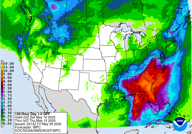
* a few scattered showers & t’storms Sat. & Sunday - rainfall amounts averaging less than an inch .... in most areas west of I-95 less than a half inch - some places no rain at all.
* some uptick in rip currents at area beaches, especially by Sat. afternoon into Sunday - always surf & swim with a buddy & as close to a lifeguard as possible... the best advice is to stay out of the ocean over the weekend.
* a bit breezy... 10-20 mph by Sat. afternoon out of the E/SE with higher gusts, especially at the beaches... 15-20 mph with gusts 20+ mph Sunday out of the northeast... so rough seas & surf too.
The area of “disturbed” weather - ‘91-L’ - disorganized clusters of showers & heavy thunderstorms - continue over parts of the Caribbean & far Southern Gulf of Mexico. In fact, satellite & radar data shows a large cluster of thunderstorms that more resembles a mesoscale convective complex vs. a tropical cyclone. Weak low pressure formed near the northeast coast of the Yucatan Peninsula Thursday (Agatha dissipated over Mexico early this week) & is moving slowly northeast. While the system “festers” & thunderstorms “burst”, the low pressure may very well have a tendency to “jump around” a bit until & unless a center can become better established. While sea surface temps. are seasonally warm - 80+ degrees F - over the Gulf & Caribbean & would support a tropical system... & mid & upper level moisture is plentiful... shear out of the west remains strong - 30+ mph [in some instances 50+ mph!] - & will likely keep what could become Alex heavily weighted with its heavy rain & some wind on the east side of any circulation. Such shear *should* limit the overall strength of this system.
The GFS model & European model have had pretty wide differences - especially in location & intensity - the past week but have been coming into better agreement. The GFS was a stud last hurricane season, & I’ve seen no reason to ride this wave into this season... at least so far (GFS did well w/ Agatha over the E. Pacific last week). The general trend & track will be to the northeast with increasing forward speed nearing & crossing Fl. by Saturday then continuing northeast gradually veering a little more east over the open Western & Central Atlantic through early next week well east of the U.S. east coast. On this track - of what looks to be a weaker system heavily weighted on the east side - heavy rain & isolated tornadoes will be the main concern for Central & South Florida late through Sat. with rapidly improving conditions Sunday while NE Fl./SE Ga. remains on the northern fringe - at most - of any possible impacts.


Water vapor imagery over the Gulf (blue & gray=dry mid & upper level air):

Wind shear analysis shows winds out of the west at more than 50 mph! over parts of the Southern Gulf & N. Caribbean:

Key West N.W.S. radar:

South Florida Water Management District:


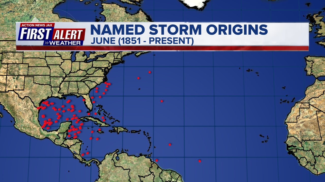
The location of development of tropical systems in June since 1851 generally favors the NW Caribbean, Gulf of Mexico & far Western Atlantic:


Saharan dust is spread west each year from Africa by the prevailing winds (from east to west over the Atlantic). Dry air - yellow/orange/red/pink. Widespread dust is indicative of dry air that can impede the development of tropical cyclones. However, sometimes “wanna’ be” waves will just wait until they get to the other side of - or away from - the plume then try to develop if other conditions are favorable. In my personal opinion, way too much is made about the presence of Saharan dust & how it relates to tropical cyclones. In any case, we’ve already has a couple of dust plumes spread west to the Caribbean & Gulf with the peak of Saharan dust typically in June & July.

2022 names..... “Alex” is the first name on the Atlantic list (names are picked at random by the World Meteorological Organization... repeat every 6 years... historic storms are retired [Florence & Michael in ’18... Dorian in ’19 & Laura, Eta & Iota in ‘20 & Ida in ‘21]). The WMO decided - beginning last year - that the Greek alphabet will be no longer used & instead there will be a supplemental list of names if the first list is exhausted (has only happened three times - 2005, 2020 & 2021). The naming of tropical cyclones began on a consistent basis in 1953. More on the history of naming tropical cyclones * here *.


East Atlantic:


Mid & upper level wind shear (enemy of tropical cyclones) analysis (CIMMS). The red lines indicate strong shear:

Water vapor imagery (dark blue indicates dry air):

Deep oceanic heat content over the Gulf, Caribbean & deep tropical Atlantic:

Sea surface temp. anomalies:


SE U.S. surface map:

Surface analysis centered on the tropical Atlantic:

Surface analysis of the Gulf:

Caribbean:

GFS wave forecast at 48 & 72 hours (2 & 3 days):


Atlantic Basin wave period forecast for 24, 48 & 72 hours respectively:


The East Pacific:


West Pacific IR satellite:

Global tropical activity:


Cox Media Group
:quality(70)/cloudfront-us-east-1.images.arcpublishing.com/cmg/OP4L4IUHEIWRTTX257DKOM4IMU.jpg)
:quality(70)/cloudfront-us-east-1.images.arcpublishing.com/cmg/GUKNEPXKO4TU3TGUXRFOFQBQLY.jpg)
:quality(70)/cloudfront-us-east-1.images.arcpublishing.com/cmg/SATRLH535RE6HIJIPS5ZLZB4XI.jpg)
:quality(70)/cloudfront-us-east-1.images.arcpublishing.com/cmg/M7DQOP5FJNTRMVP5QYWYEBACAI.jpg)
:quality(70)/cloudfront-us-east-1.images.arcpublishing.com/cmg/YFVQFPSEYFGUJNN5FIL45PWXNM.jpg)