:quality(70)/cloudfront-us-east-1.images.arcpublishing.com/cmg/JIFG55NSN5HKZK6LKEZ4C7UU5I.jpg)
Jacksonville, Fl. — The “Buresh Bottom Line”: Always be prepared!.....First Alert Hurricane Preparation Guide... City of Jacksonville Preparedness Guide... Georgia Hurricane Guide.
STAY INFORMED: Get the * FREE * First Alert Weather app
FREE NEWS UPDATES, ALERTS: Action News Jax app for Apple | For Android
WATCH “Preparing for the Storm”
WATCH “The Ins & Outs of Hurricane Season”
READ the First Alert Hurricane Center “Survival Guide”
LISTEN & WATCH “Surviving the Storm” - WOKV Radio & Action News Jax
***** ALWAYS CHECK & RE-CHECK THE LATEST FORECAST & UPDATES! *****
REMEMBER WHEN A TROPICAL STORM OR HURRICANE IS APPROACHING: Taping windows is *not* recommended & will not keep glass from breaking. Instead close curtains & blinds.
Realize the forecast cone (”cone of uncertainty”) is the average forecast error over a given time - out to 5 days - & *does not* indicate the width of the storm &/or where damage that might occur.

Impacts for Jacksonville/NE Fl./SE Ga. from “Bret” or “Cindy”: None.
A Tropical Storm WARNING is in effect for: * Dominica * St. Lucia * Martinique * Barbados * St. Vincent and the Grenadines....
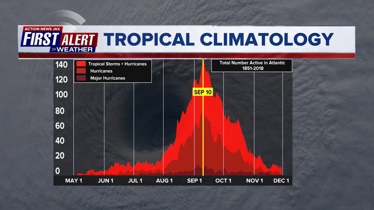
The strong & well organized tropical wave - ‘92-L’ was upgraded to tropical depression #3 over the Eastern Atlantic Mon. morning then to tropical storm Bret Mon. afternoon & has been slowly strengthening since reaching near hurricane strength early Thu. This (a named storm developing so far to the east in the deep tropical Atlantic) is an unusual development for so early in the season. In fact, it’s the 7th earliest occurrence for the 3rd named Atlantic storm (avg. for the first one is June 20th) & is the farthest east in the tropical Atlantic for a storm to be named so early in the season.
Bret took advantage of: (1) an early season uptick in tropical waves that have already been marching westward... (2) above avg. & warm ocean temps. over most of the lower Atlantic Basin (has cooled to the north)... & (3) the El Nino is in its infancy & is still strengthening (which may help to slow the season near its climatological peak in Sept./early Oct.).
The favorable conditions for intensification for Bret have come to an end after peaking near hurricane strength early Thu. The strong shear is already showing signs of impacting the western portion of Bret’s circulation & hurricane hunter aircraft have verified a tilted system from southwest to northeast with stronger but increasingly disorganized convection over the eastern & northern half of the circulation removed from the center. Bret will encounter even stronger wind shear - on the order of 25-40 mph out of the west increasing to 50-60 mph over the Western Caribbean - + some pockets of dry air through Fri. into the weekend. Strong shear over the Caribbean is typical of early season conditions & often times a hallmark through a good part of the hurricane season when there is an El Nino (such is the case this year). This increasingly hostile environment should quickly dishevel Bret & rapid weakening is expected Fri. into the weekend. Little more than a tropical wave or trough should be left over the Central or Southern Caribbean by Sunday if not sooner.
Given the weaker system, Bret will continue westward & will have few serious consequences for any of the Caribbean island nations (beyond the Windward [Lesser Antilles] Islands) staying well south of Puerto Rico & Hispaniola. The stronger GFS has been better on intensity, the more south & west European has been better on track. For the Central Lesser Antilles, the bands of heavy rain & strong winds will be followed by rapid improvement Fri. Note that hurricane hunter aircraft & buoys indicate virtually all of the stronger winds north & east of the center with relatively light winds south & west of the center.
(2) The second tropical wave - ‘93-L’ behind - to the east of - Bret was upgraded early Thu. to tropical depression #4 & tropical storm “Cindy” Thu. night & continues to move west/northwest. Cindy will turn more sharply to the northwest the next few days thanks to a trough of low pressure over the SW Atlantic. All indications are that Cindy will turn northwest then northward well east/northeast of the Lesser Antilles AND Puerto Rico & far to the east of Florida. By early next week, wind shear increases & what should be Cindy will likely start to weaken.
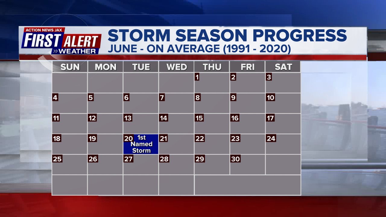
The 3rd named storm of the Atlantic season does not - on average - occur until Aug. 3. According to Dr. Phil Klotzbach/CSU: “Cindy is the 2nd June tropical cyclone to form in tropical Atlantic (south of 23.5N, east of 60W) this month. No other June on record has had >1 storm formation in tropical Atlantic.”
(3) Yet a 3rd wave has come off the coast of Africa & has at least some potential for short term development over the Eastern Atlantics before conditions become less favorable.


(4) Forecast models - for the most part - show little in the way of organized low pressure developing over or near the Gulf of Mexico through Fri. into the weekend....
The combination of a weak wave over the Southwest Caribbean + a weakening upper level trough extending southward to the Gulf still *could* lead to a surface reflection (low pressure system) forming over or near the Eastern Gulf &/or near Florida over the next few days. The low is a “conditional” potential development & any possible surface low would likely be quite weak The pattern is already wet over Fl. thanks to the nearby upper trough, so any tropical input would only add to the potential for significant flooding.
We’ll monitor the Gulf & areas near Fl. for any persistent convection that might be the hint of a low pressure area trying to form.


Water vapor loop (dark blue/yellow is dry mid & upper level air):


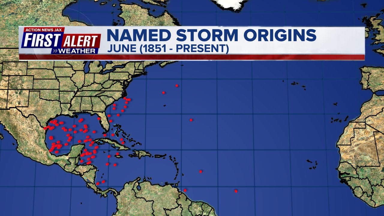
June tropical cyclone origins:
Averages below based on climatology for the Atlantic Basin for June:

Wind shear:


Saharan dust spreads west each year from Africa by the prevailing winds (from east to west over the Atlantic). Dry air - yellow/orange/red/pink. Widespread dust is indicative of dry air that can impede the development of tropical cyclones. However, sometimes “wanna’ be” waves will just wait until they get to the other side of - or away from - the plume then try to develop if other conditions are favorable. In my personal opinion, way too much is made about the presence of Saharan dust & how it relates to tropical cyclones. In any case, the peak of Saharan dust typically is in June & July.

2023 names..... “Cindy” is the next name on the Atlantic list (names are picked at random by the World Meteorological Organization... repeat every 6 years). Historic storms are retired [Florence & Michael in ’18... Dorian in ’19 & Laura, Eta & Iota in ‘20, Ida in ‘21 & Fiona & Ian in ‘22]). In fact, this year’s list of names is rather infamous with “Katrina”, “Rita” & “Wilma” retired from the ‘05 list & “Harvey”, “Irma”,“Maria” & “Nate” from the ‘17 list. The WMO decided - beginning in 2021 - that the Greek alphabet will be no longer used & instead there will be a supplemental list of names if the first list is exhausted (has only happened three times - 2005, 2020 & 2021). The naming of tropical cyclones began on a consistent basis in 1953. More on the history of naming tropical cyclones * here *.


East Atlantic:


Mid & upper level wind shear (enemy of tropical cyclones) analysis (CIMMS). The red lines indicate strong shear:

Water vapor imagery (dark blue indicates dry air):

Deep oceanic heat content over the Gulf, Caribbean & deep tropical Atlantic. The brighter colors will expand rather dramatically by Aug./Sept./Oct.:

Sea surface temp. anomalies:


SE U.S. surface map:

Surface analysis centered on the tropical Atlantic:

Surface analysis of the Gulf:

Caribbean:

GFS wave forecast at 48 & 72 hours (2 & 3 days):


Atlantic Basin wave period forecast for 24, 48 & 72 hours respectively:


The East Pacific (may see development by the weekend south of Mexico):


West Pacific:

Global tropical activity:


Cox Media Group
:quality(70)/d1hfln2sfez66z.cloudfront.net/05-17-2024/t_6fd7c9d9afc044f790ee3229f046adfb_name_file_960x540_1200_v3_1_.jpg)
:quality(70)/d1hfln2sfez66z.cloudfront.net/05-15-2024/t_adc93bdd40804d3b869c26f7dd7501cb_name_file_960x540_1200_v3_1_.jpg)
:quality(70)/d1hfln2sfez66z.cloudfront.net/05-16-2024/t_1885e49a6e644a28aab951486230b343_name_mon_jax_BAM3_Controversial_Cop_Training_mon_jax_BAM3_Controversial_Cop_Training_02.png)
:quality(70)/d1hfln2sfez66z.cloudfront.net/05-18-2024/t_83b786ced78542ac882e86d652822769_name_file_960x540_1200_v3_1_.jpg)
:quality(70)/cloudfront-us-east-1.images.arcpublishing.com/cmg/TQQE4ODSDFDXZIS3SA3M4C4UFQ.jpg)