
Jacksonville, Fl. — THE TROPICS:
***** ALWAYS CHECK & RE-CHECK THE LATEST FORECAST & UPDATES! ****
Tropics threats/impacts for Jacksonville/NE Florida/SE Georgia: None
The Atlantic Basin Overview:
The Atlantic hurricane season is June 1st through Nov. 30th.
The forecast for the Atlantic season ahead from NOAA & Colorado St. University (Dr. Klotzbach) is for a below average season in terms of the number of named storms due to a developing El Nino - a warming of the equatorial Pacific. Of course, it take just one storm in the wrong place at the wrong time to become a memorable season.
The first named storm of the season doesn’t develop until June 20th on average.

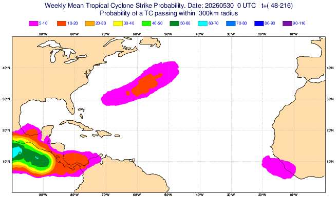
During this first week of the hurricane season, no areas of immediate concern across the Atlantic, Gulf & Caribean.
There has been a lot of “scuttle butt” regarding possible early season development over especially the Gulf &/or W/SW Atlantic, but I don’t see much at this point. Low pressure does seem destined to develop over the Western Atlantic this week due to an upper level trough of low pressure but significant tropical development is unlikely at this time.
A cold front will settle across Fl. this week & become stationary by late week extending west/east from the Gulf to the Western Atlantic. Stalled fronts can become a “playground” for tropical development, so it’ll be an area to watch.


‘Velocity potential anomalies’ below. shows “Rising” air (green lines) equates with an uptick in overall convection. With rising air, conditions are generally more favorable for tropical development. Where there are brown lines, the air is generally sinking & is often less conducive to tropical cyclones (though not impossible to have development).
The first couple of weeks of June will be dominated by rising air, so we might see attempts at some tropical development despite the typical early season strong wind shear. The Eastern Pacific is particularly favorable (more on the Pacific near the bottom).

The “Buresh Bottom Line”: Always be prepared!.....First Alert Hurricane Preparation Guide... City of Jacksonville Preparedness Guide... Georgia Hurricane Guide.
STAY INFORMED: Get the * FREE * First Alert Weather app
FREE NEWS UPDATES, ALERTS: Action News Jax app for Apple | For Android
WATCH “Preparing for the Storm”
READ the First Alert Hurricane Center “Preparation Guide”
LISTEN “First Alert Weather: Preparing for the Storm”
Federal Alliance for Safe Homes (FLASH) * here *.
REMEMBER WHEN A TROPICAL STORM OR HURRICANE IS APPROACHING: Taping windows is *not* recommended & will not keep glass from breaking. Instead close curtains & blinds.
Realize the forecast cone (”cone of uncertainty”) is the average forecast error over a given time - out to 6 days - & *does not* indicate the width of the storm &/or where damage might occur.

The map below shows the *average* time for a tropical wave coming off Africa to travel west & northwest. Only about 1 in 5 tropical waves - on average - become a tropical cyclone of some sort (depression/storm/hurricane):


Water vapor loop (dark blue/yellow is dry mid & upper level air):


June Atlantic tropical cyclone origins:

Averages below based on climatology for the Atlantic Basin for June:

Wind shear (red - strong shear; green - low shear). Shear is typically strong to start the hurricane season:


Saharan dust spreads west each year from Africa driven by the prevailing winds (from east to west over the Atlantic). Dry air = yellow/orange/red/pink. Widespread dust is indicative of dry air that *can* interfere with the development of tropical cyclones. However, sometimes “wanna’ be” waves will just wait until they get to the other side of - or away from - the dust plume then try to develop if other conditions are favorable (we saw this with Beryl & Debby last year). It’s my personal opinion that there is way too much “hoopla” about the presence of Saharan dust & how it relates to tropical cyclones. In any case, the peak of Saharan dust typically is in June & July, & we are indeed seeing a large “blobs” of Saharan dust over the Central & Eastern Atlantic that’s thinning with westward extent but enough of it to make for hazy skies across the Caribbean & - at times - across parts of Florida.

2026 names..... “Arthur” is the first name on the Atlantic list (names are picked at random by the World Meteorological Organization... repeat every 6 years). Historic storms are retired [Florence & Michael in ’18... Dorian in ’19 (the last time this year’s list was used) ... Laura, Eta & Iota in ‘20 ... Ida in ‘21 ... Fiona & Ian in ‘22... no names were retired in ‘23 for the first time since 2014... Beryl, Helene & Milton in 2024 & Melissa in 2025). The WMO decided - beginning in 2021 - that the Greek alphabet will be no longer used & instead there will be a supplemental list of names if the first list is exhausted (has only happened three times - 2005, 2020 & 2021). The naming of tropical cyclones began on a consistent basis in 1953. More on the history of naming tropical cyclones * here *.

Hurricane season climatology:


East Atlantic:


Mid & upper level wind shear (enemy of tropical cyclones) analysis (CIMMS). The red lines indicate strong shear - typically the “enemy” of tropical systems:

Water vapor imagery (dark blue indicates dry air):

Deep oceanic heat content over the Gulf, Caribbean & tropical Atlantic. Brighter colors = warmer temps.:

Sea surface temps.:

Sea surface temp. anomalies:

SE U.S. surface map:

Surface analysis centered on the tropical Atlantic:

Surface analysis of the Gulf:

Caribbean:

Atlantic Basin wave period forecast for 24, 48, 72 & 96 hours respectively:


East & Central Pacific:
This basin will most likely be the generally more active area in ‘26 due to the anticipated El Nino.


Central Pacific:

Hawaii satellite imagery:


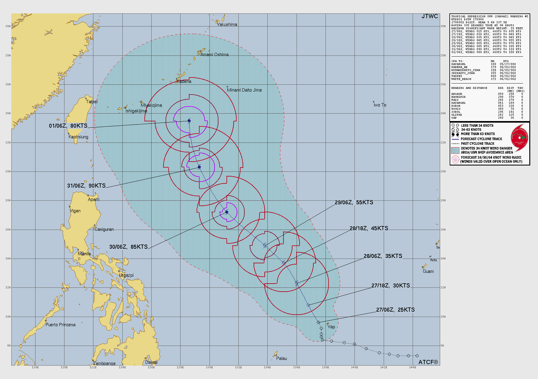
West Pacific:
“Jangmi” will impact Japan as a strong tropical storm or low end typhoon:
Global tropical activity:


Cox Media Group


