JACKSONVILLE, Fla. — Action News Jax’s First Alert Weather Team is actively tracking Tropical Storm Idalia and its impacts on Northeast Florida and Southeast Georgia.
WATCH THE FORECAST | DOWNLOAD THE APPS
Here is the latest from the First Alert Weather Center:
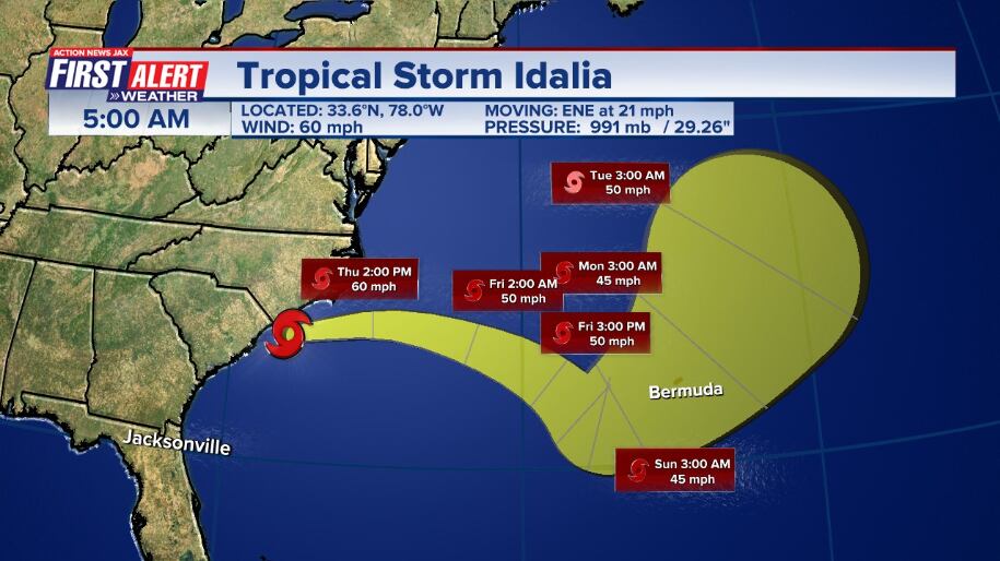
Just before the 5 p.m. advisory, Idalia was downgraded to a tropical storm.
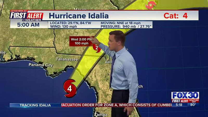
Around 11 a.m., Idalia became a Category 1.
As of 9 a.m., Idalia was downgraded to a Category 2.
As of 7:49 a.m., Idalia made landfall at Keaton Beach, Florida.
As of 7 a.m., Idalia went down to a Category 3.

As of 4:58 a.m., Hurricane Idalia reached Category 4 status.
First Alert Chief Meteorologist Mike Buresh said the biggest impacts will be from approximately the Central/Eastern Panhandle to the Big Bend to the north of Tampa on the west coast of Fl. There will be lots of folks traveling late in the week with Labor Day weekend just around the corner so stay up to date on the latest forecasts, but it does appear that Idalia will have cleared the U.S. by at least Fri. though may linger east of the Carolina’s but offshore into the weekend.
Don’t focus too much on the center of the storm as impacts will be far away from the center point of Idalia including a storm surge possibly near half a foot for Tampa Bay. Traveling west on I-10 from Lake City to the Eastern Panhandle will be difficult at best. High winds will likely down trees & power lines & cause property damage across a good part of Southeast Ga.
LISTEN: Mike Buresh ‘All the Weather, All the Time’ Podcast
Once over the W. Atlantic, a loop back to the south & then southwest will be *possible* next week, but Idalia looks to be a good deal weaker at that point & - while interesting & topical - I would expect whatever is left of Idalia will be much weaker.
Some forecast models simply slow Idalia over the Atlantic while meandering (rather than make the full turn to the southwest). Such tracks have occurred before, by the way as Ivan in 2004 powered through the Western Fl. Panhandle then looped across the Eastern U.S. to the Atlantic before turning southwest then west & moving back across South Fl. - much weaker but Ivan literally went full circle.
INTERACTIVE RADAR: Keep track of the rain as it moves through your neighborhood
For more information, read Talking the Tropics With Mike: Powerful Idalia makes landfall on the Big Bend of Florida
Follow Action News Jax Meteorologists on Twitter for updates:
Mike Buresh | Garrett Bedenbaugh | Corey Simma | Trevor Gibbs


