JACKSONVILLE, Fla. — This morning is refreshingly cool with temperatures in the 50s inland and 70s closer to the coast under partly cloudy skies.
- Record low for Jacksonville: 61 (1966, 1972)
- Today will not be as windy as yesterday, but still locally breezy with onshore winds at 10-15 mph.
- Unseasonably dry air will continue through the day and into the afternoon.
- Comfortable humidity will last for a few days into the first half of the weekend.
- We will be mainly dry now through Monday.
- Highs will be in the upper 70s along the coast and lower 80s well inland.
- Mornings will feel comfortable with temperatures in the lower 60s inland and lower 70s at the beaches.
- A few inland SE Georgia neighborhoods will likely drop to the upper 50s tomorrow morning.
- The weekend looks great, weather wise.
- A few afternoon showers/storms return early next week.
TROPICS:
- No areas of concern.
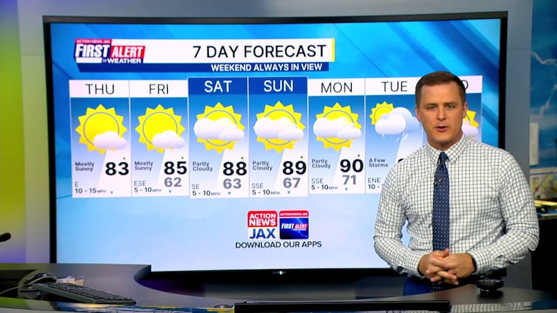
TODAY: Partly cloudy and breezy. Low humidity. HIGH: 83
TONIGHT: Mostly clear. LOW: 62
FRIDAY: Mostly sunny. 62/85
SATURDAY: Mostly sunny. 63/88
SUNDAY: Mostly sunny. Hot with more humidity. 67/89
MONDAY: Partly cloudy. 71/90
TUESDAY: Mostly cloudy with a few afternoon showers and storms. 73/88
WEDNESDAY: Partly cloudy with a few afternoon showers/storms. 73/88
WATCH THE FORECAST | DOWNLOAD THE APPS
Follow Action News Jax Meteorologists on Twitter for updates:
Mike Buresh | Garrett Bedenbaugh | Corey Simma | Trevor Gibbs
ALLERGY TRACKER: See what the pollen counts look like in our area
LISTEN: Mike Buresh ‘All the Weather, All the Time’ Podcast
INTERACTIVE RADAR: Keep track of the rain as it moves through your neighborhood
SHARE WITH US: Send us photos of the weather you’re seeing in your area ⬇️


