:quality(70)/cloudfront-us-east-1.images.arcpublishing.com/cmg/WW5AJL3ARQUGDQMAQUNSFX4CLE.jpg)
Jacksonville, Fl. — The “Buresh Bottom Line”: Always be prepared!.....First Alert Hurricane Survival Guide... City of Jacksonville Preparedness Guide... Georgia Hurricane Guide.
STAY INFORMED: Get the * FREE * First Alert Weather app
FREE NEWS UPDATES, ALERTS: Action News Jax app for Apple | For Android
WATCH “The Ins & Outs of Hurricane Season”
WATCH “Preparing for the Storm”
READ the First Alert Hurricane Center “Survival Guide”
***** ALWAYS CHECK & RE-CHECK THE LATEST FORECAST & UPDATES! *****
LOCAL IMPACTS FROM “Ida” FOR JACKSONVILLE/NE FL./SE GA.:
* virtually none
* anyone living along the Gulf Coast or with travel plans along the Gulf Coast needs to stay up to date on the daily forecasts.
REMEMBER WHEN A TROPICAL STORM OR HURRICANE IS APPROACHING: Taping windows is *NOT* helpful & will not keep glass from breaking... & realize the cone is the average forecast error over a given time - out to 5 days - & *does not* indicate the width of the storm &/or damage therefore do not become fixated on the center of a tropical system.

Ida:
Heads-up & don’t get caught off-guard anywhere from Texas to the Western Florida Panhandle with particular focus on Louisiana - for the moment. This wave originated off of Africa & has been steadily marching west waiting for a more favorable environment (less dust, more moist atmosphere & less shear). It seems the wave has found that more favorable area - upgraded to t.d. #9 Thu. morning then t.s. “Ida” late Thu. - which becomes even more conducive for strengthening over the Gulf over the weekend. In fact, a warm “eddy” is over the Gulf of Mexico - similar to 2005 [Katrina & Rita] & Ida should move over or very near this deep, warm water through the weekend.
Forecast models have continued to trend north & remain strong in their development of a tropical cyclone, probably a hurricane. The European & GFS models remain in quite remarkable agreement - for this far out - of a landfalling named storm on the Western Gulf coast Sun. night/early next week - the Euro just a little west of the GFS landfall over Central Louisiana a little west of New Orleans. The UKMET model is gradually falling into line but is still a little more west & a little slower. I should point out that there is still a good deal of uncertainty, especially since the system has yet to develop any kind of core/center. I’m not so sure the eastward adjustment is complete. Realize the “short cut” to the north (vs. earlier forecasts) will result in an earlier landfall along the Gulf Coast.
Ida has been dumping heavy rain on Jamaica & nearby areas of the Caribbean & Cuba. By the time the tropical cyclone is near the Yucatan Peninsula & Western Cuba, conditions become more favorable other than some brief land interaction. Once over the Gulf of Mexico, it appears conditions are quite ripe for strengthening with concern increasing about a *possible* landfall while the storm is at or nearing its peak intensity.
The track looks to be somewhere in-between Fred from early last week (turn toward the north with a landfall along the NE Gulf coast) & Grace late last week (due west into Mexico because of a strong ridge). A soft spot or alleyway is forming over the Northern Gulf which will allow the northern turn in the longer run - over the weekend into early next week right up to landfall.
‘I’ is rather notorious over the years & is the most retired letter of the Atlantic seasonal alphabet. Since 1955, there have been 11 ‘I’ names retired including Iris, Isidore, Isabel & Ivan in consecutive years from 2001-’04. Most recently Irma was retired in 2017 & Iota in 2020. Tied for second in retired letters is ‘C’ & ‘F’ with nine each.
Again - anyone living along the Gulf Coast &/or traveling to the area should stay up to date on the latest forecasts/development every single day through early next week.


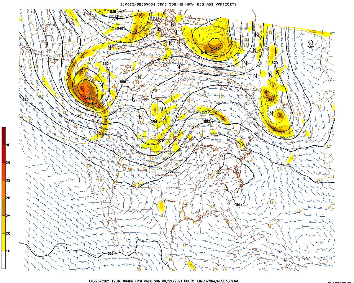
500 mb (~30,000 feet) forecast map below for Sunday, 08/29. Note the weakness along the Gulf Coast with a somewhat soft ridge/high pressure along the U.S. east coast while an trough of low pressure moves into the Midwest. Just how weak the high pressure near the east coast is will be critical on how far north & east ‘99-L’ might track.


Meanwhile.... an old but rather active tropical wave combined with a surface trough of low pressure continues to move west & is crossing the Florida Peninsula. Satellite & radar images nicely show the feature - combined with a weak upper level disturbance - producing a good amount of convection to the east of the wave axis (typical since that’s where the best lift occurs). The wave will weaken/dampen out while moving west but will help enhance showers & storms across Fl. into Friday. As long as no convective clusters become persistent, surface development is unlikely.... & is not indicated by forecast models.

South Florida Water Management District:

Elsewhere over the Atlantic ... a couple of strong tropical waves are over the Central & Eastern Atlantic. While each may eventually develop into a tropical cyclone, the good news is that it appears these systems do not make it across the Atlantic staying over open water well to the east & southeast of Bermuda. For right now, the Bermuda High across the Atlantic seems to be generally weaker into early Sept. - important for any potential long track tropical systems coming out of the deep tropics.


We’re now just a couple of weeks from the peak of the hurricane season (Sept. 10), so just from a climatological point, we should see an uptick in Atlantic activity. But there are also other indications to track including the MJO, seasonally warm sea surface temps. & rather impressive deep oceanic heat content.
Sea surface temps. across the Atlantic are now near to above avg. across much of the basin (2nd image below) & - even more importantly - deep oceanic heat content is becoming impressive & the “equivalent oceanic heat content” - namely depth averaged temperature in the upper 300 m (~984 feet) - is even more impressive all the way from Africa to the Gulf of Mexico. Such an ocean water temp. pattern is conducive to long track deep tropical Atlantic tropical cyclones & can lead to a more favored regime for rapid intensification cycles. From an AMS research paper in ‘08 Mainelli, DeMaria, Shay, Goni: “Results show that for a large sample of Atlantic storms, the OHC variations have a small but positive impact on the intensity forecasts. However, for intense storms, the effect of the OHC is much more significant, suggestive of its importance on rapid intensification. The OHC input improved the average intensity errors of the SHIPS forecasts by up to 5% for all cases from the category 5 storms, and up to 20% for individual storms, with the maximum improvement for the 72–96-h forecasts. The statistical results obtained indicate that the OHC only becomes important when it has values much larger than that required to support a tropical cyclone.” More recent research continues to indicate similar correlations.


Saharan dust. Dry air - yellow/orange/red/pink. Widespread dust is most common earlier in the hurricane season & is indicative of dry air that can impede the development of tropical cyclones. However, sometimes “wanna’ be” waves will just wait until they get to the other side of the plume then try to develop if everything else happens to be favorable.

2021 names..... “Julian” is the next name on the Atlantic list (names are picked at random by the World Meteorological Organization... repeat every 6 years... historic storms are retired (Florence & Michael in ’18... Dorian in ’19 & Laura, Eta & Iota in ‘20). Last year - 2020 - had a record 30 named storms. The WMO decided beginning in 2021 that the Greek alphabet will be no longer used & instead there will be a supplemental list of names if the first list is exhausted (has only happened twice - 2005 & 2020). More on the history of naming tropical cyclones * here *.


East Atlantic:


Mid & upper level wind shear (enemy of tropical cyclones) analysis (CIMMS). The red lines indicate strong shear:

Water vapor imagery (dark blue indicates dry air):

Deep oceanic heat content continues to increase across the Gulf, Caribbean & deep tropical Atlantic & has become pretty impressive from the Central/NW Caribbean into the Gulf of Mexico:

Sea surface temp. anomalies:

SE U.S. surface map:

Surface analysis centered on the tropical Atlantic:

Surface analysis of the Gulf:

Caribbean:

Atlantic Basin wave forecast for 24, 48 & 72 hours respectively:


The East Pacific:
Nora will have impacts on the Central Mexican coast as well as the Baja of California:


West Pacific IR satellite:

Global tropical activity:


Cox Media Group
:quality(70)/cloudfront-us-east-1.images.arcpublishing.com/cmg/ZTI23OI2UREPVASYSWEIYZBRK4.png)
:quality(70)/d1hfln2sfez66z.cloudfront.net/05-02-2024/t_bed3e904b9e54d239b693214e5b7b5bc_name_file_960x540_1200_v3_1_.jpg)
:quality(70)/d1hfln2sfez66z.cloudfront.net/05-04-2024/t_1d4d3132700146178ae703ce930392b6_name_file_960x540_1200_v3_1_.jpg)
:quality(70)/cloudfront-us-east-1.images.arcpublishing.com/cmg/DZZZEVZAAJB6RLOCFSJZMGBWZI.png)
:quality(70)/d1hfln2sfez66z.cloudfront.net/05-03-2024/t_acc6d22677e542e3a225bedc580d1753_name_file_1920x1080_1200_v3_1_.jpg)