:quality(70)/cloudfront-us-east-1.images.arcpublishing.com/cmg/JIFG55NSN5HKZK6LKEZ4C7UU5I.jpg)
Jacksonville, Fl. — The “Buresh Bottom Line”: Always be prepared!.....First Alert Hurricane Preparation Guide... City of Jacksonville Preparedness Guide... Georgia Hurricane Guide.
STAY INFORMED: Get the * FREE * First Alert Weather app
FREE NEWS UPDATES, ALERTS: Action News Jax app for Apple | For Android
WATCH “Preparing for the Storm”
WATCH “The Ins & Outs of Hurricane Season”
READ the First Alert Hurricane Center “Survival Guide”
LISTEN & WATCH “Surviving the Storm” - WOKV Radio & Action News Jax
***** ALWAYS CHECK & RE-CHECK THE LATEST FORECAST & UPDATES! *****
REMEMBER WHEN A TROPICAL STORM OR HURRICANE IS APPROACHING: Taping windows is *not* recommended & will not keep glass from breaking. Instead close curtains & blinds.
Realize the forecast cone (”cone of uncertainty”) is the average forecast error over a given time - out to 5 days - & *does not* indicate the width of the storm &/or where damage that might occur.

*** LOCAL (Jacksonville/NE Fl./SE Ga.) IMPACTS FROM THE TROPICS: None through the weekend...
The Atlantic Basin Overview:
** “Idalia” made landfall on the Florida Big Bend a little before 8am Wed.... moved across the far Southeast U.S. & is back over the Western Atlantic as a post-tropical cyclone but could become tropical again near Bermuda where a tropical storm WARNING is in effect.
** Meanwhile...“Franklin” hit Haiti & especially the Dominican Republic with very heavy rain last Wed. The hurricane rapidly intensified to a high end Cat. 4 Monday when the storm finally found the “sweet spot” of the SW Atlantic but at least is not a threat to land.
** Tropical storm Jose formed over the Central Atlantic but will be not threat to land.
** Gert has re-developed but should be short-lived again.
** T.D. #12 has formed over the far East Atlantic is likely to become “Katia” but will remain over the far E. Atlantic.
** A strong tropical wave will emerge off the coast of Africa over the weekend & has a *chance* to be a long track Atlantic hurricane.

(1) The area of disturbed weather near the Yucatan - Tropical depression #10 - strengthened into tropical storm “Idalia” late Sunday morning & the third hurricane of the ‘23 Atlantic season early Tuesday... & steadily strengthened overnight into early Wed. with a peak at Cat. 4 Tue. night before making landfall early Wed. - about 7:50am - during an eyewall replacement cycle. This cycle along with friction from land helped begin a slight & slow weakening trend while moving ashore. The weakening center of Idalia reached the coast again early Thu. morning between Myrtle Beach & Charleston & Idalia became post-tropical shortly thereafter.
Steering currents have collapsed & Idalia will meander over the Western Atlantic this weekend not far from Bermuda where a tropical storm WARNING is now in effect. It’s possible Idalia will become tropical again while turning northward by early next week. From there forecast models are in disagreement on whether or not an upper level trough will finally capture Idalia or not.


Spaghetti plots including ensemble (instead of running just a single forecast, the computer model is run a number of times from slightly different starting conditions. The complete set of forecasts is referred to as the ensemble, and individual forecasts within it as ensemble members.) “Idalia”:


(2) “Franklin” has been a long lasting tropical cyclone becoming a powerful - Cat. 4 for a time - hurricane east of the Bahamas & producing tropical storm force winds on the island of Bermuda Wed. Franklin will move steadily northeast & eventually become extra-tropical over the N. Atlantic with no direct impacts to any land areas.

#firstalertwx whoa! @ActionNewsJax @WOKVNews https://t.co/907MkzK3zy
— Mike Buresh (@MikeFirstAlert) August 25, 2023


(3) Tropical depression #11 formed over the Central Atlantic Wed. & was upgraded to tropical storm “Jose” early Thu. but is expected to be short-lived with no threat to land areas as Jose will soon be absorbed by the much larger circulation that is Franklin.

(4) And yet another tropical wave - ‘94-L’ - now t.d. #12 - is over the far Eastern Atlantic. This system will soon be “Katia” but will stay over the far Eastern Atlantic.


(5) A tropical wave will move west off of Africa over the weekend. This wave has a good chance to develop over the main development region (MDR) through next week & could become a textbook long track hurricane. There *COULD* be a threat to parts of the Caribbean &/or the U.S. in about 10-14 days but plenty of time to see how things - steering currents in particular - play out. But it (would be “Lee”) is something to keep an eye on.
Check out the upper oceanic heat content (UOHC) [tropical cyclone heat potential/TCHP] across the SW Atlantic, Gulf & Caribbean. The warmth is very deep. But keep in mind warm ocean temps. alone doesn’t necessarily equate to a “big” hurricane season (need other ingredients & factors to be favorable too) but it’s obvious there is a lot of very warm water at great depths over the Caribbean & Gulf of Mexico:


Water vapor loop (dark blue/yellow is dry mid & upper level air):


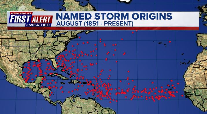
July tropical cyclone origins:
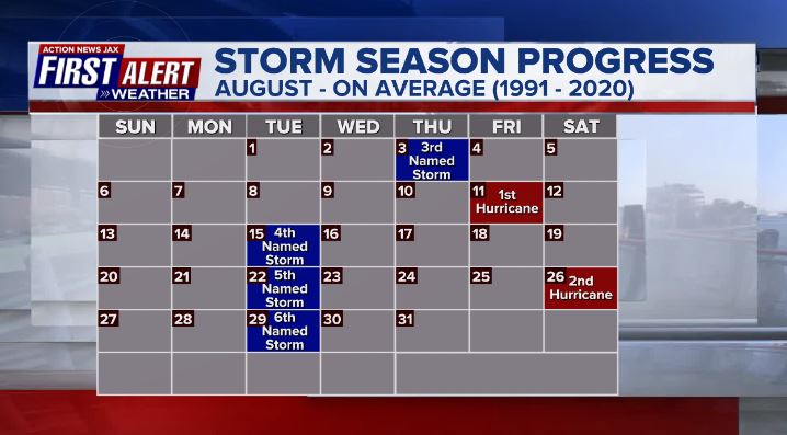
Averages below based on climatology for the Atlantic Basin for August:
Wind shear:


Saharan dust spreads west each year from Africa by the prevailing winds (from east to west over the Atlantic). Dry air - yellow/orange/red/pink. Widespread dust is indicative of dry air that can impede the development of tropical cyclones. However, sometimes “wanna’ be” waves will just wait until they get to the other side of - or away from - the plume then try to develop if other conditions are favorable. In my personal opinion, way too much is made about the presence of Saharan dust & how it relates to tropical cyclones. In any case, the peak of Saharan dust typically is in June & July.

2023 names..... “Katia” is the next name on the Atlantic list (names are picked at random by the World Meteorological Organization... repeat every 6 years). Historic storms are retired [Florence & Michael in ’18... Dorian in ’19 & Laura, Eta & Iota in ‘20, Ida in ‘21 & Fiona & Ian in ‘22]). In fact, this year’s list of names is rather infamous with “Katrina”, “Rita” & “Wilma” retired from the ‘05 list & “Harvey”, “Irma”,“Maria” & “Nate” from the ‘17 list. The WMO decided - beginning in 2021 - that the Greek alphabet will be no longer used & instead there will be a supplemental list of names if the first list is exhausted (has only happened three times - 2005, 2020 & 2021). The naming of tropical cyclones began on a consistent basis in 1953. More on the history of naming tropical cyclones * here *.

East Atlantic:


Mid & upper level wind shear (enemy of tropical cyclones) analysis (CIMMS). The red lines indicate strong shear:

Water vapor imagery (dark blue indicates dry air):

Deep oceanic heat content over the Gulf, Caribbean & deep tropical Atlantic. The brighter colors are expanding dramatically as we near the peak of the hurricane season.:

Sea surface temp. anomalies:


SE U.S. surface map:

Surface analysis centered on the tropical Atlantic:

Surface analysis of the Gulf:

Caribbean:

GFS wave forecast at 48 & 72 hours (2 & 3 days):


Atlantic Basin wave period forecast for 24, 48 & 72 hours respectively:


East/Central Pacific:
I wrote about “Hilary” near the top after the Atlantic waves. Elsewhere.....


West Pacific:

Global tropical activity:


“Saola” will skirt the east coast of China the next few days:

“Haikui” is forecast to impact Taiwan by the weekend:

“Kirogi”:


Cox Media Group
:quality(70)/cloudfront-us-east-1.images.arcpublishing.com/cmg/YFVQFPSEYFGUJNN5FIL45PWXNM.jpg)
:quality(70)/d1hfln2sfez66z.cloudfront.net/07-26-2024/t_c813fb310b044b9a937ea03a38306cf5_name_file_960x540_1200_v3_1_.jpg)
:quality(70)/cloudfront-us-east-1.images.arcpublishing.com/cmg/OP4L4IUHEIWRTTX257DKOM4IMU.jpg)
:quality(70)/cloudfront-us-east-1.images.arcpublishing.com/cmg/M7DQOP5FJNTRMVP5QYWYEBACAI.jpg)
:quality(70)/cloudfront-us-east-1.images.arcpublishing.com/cmg/GUKNEPXKO4TU3TGUXRFOFQBQLY.jpg)